Search results for #IowaWeather
Cover those plants tonight! Freeze warnings and frost advisories will be in effect as temperatures are expected to drop back into the lower 30s. #iawx #IowaWeather


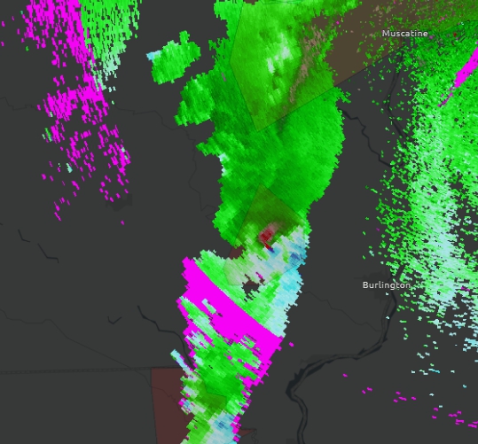
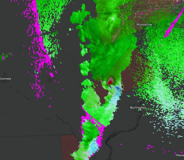
Classic shape and evolution of this storm that is producing a (confirmed) large wedge #tornado doing damage! Anyone in the path of this storm needs to be in a shelter! Mediapolis is nearest town! #iowaweather #iawx #ilwx


Temperatures will be above average as we head into the weekend. By Sunday (pictured below), highs will range from the upper 70s across northern Iowa to the mid 80s across southwest Iowa. #iawx #IowaWeather


Temperatures are going to be warming up. There is a 60% to 80% probability of above normal temperatures from Sunday through Thursday next week. Normal highs are in the 60s. Temperatures are looking to be in the 70s with some places even hitting the 80s! #iawx #IowaWeather


Colder winters in Iowa actually prove that global warming is a reality iowacapitaldispatch.com/2024/04/07/col… via @IowaCapDispatch #Iowa #IowaNews #IowaLife #IowaWinters #IowaWeather #GlobalWarming #climatechange #Okoboji #EnvironmentalScience #PolarIceCaps #Weather #ExtremeWeather #covercrops
Warmer weather at Okoboji: What it means for the lakes and those who use them iowacapitaldispatch.com/2024/04/06/war… @IowaCapDispatch #Climate #IowaWeather #Okoboji #Iowa #IowaNews #IowaLife #IDNR #IowaGreatLakes #GlobalWarming #algae #CleanWater #Parasites #Tornadoes #drought #flashfloods
Rain will move through the state Saturday night into Sunday. There will be the chance for lingering showers on Monday across northern Iowa. Total rainfall amounts will range from 0.25" to 0.5" across the state. #iawx #IowaWeather

It's going to be a bit of a roller coaster the next few days. Pleasant weather Friday, then strong winds and elevated fire danger on Saturday, then showers and storms at times from Saturday night to Sunday. Hang onto your hats folks! #iowaweather

Snow is coming down at a good clip across portions of eastern Iowa this Wednesday morning. Some roadways are being reported as partially covered. #iawx #IowaWeather #snow

A wind advisory will go into effect 1AM and will remain in effect through 10PM Wednesday. Northwest winds gusting up to 50-mph will be possible. #iawx #IowaWeather #windadvisory


There will be a risk of a few strong to severe storms capable of large hail in southern Iowa. These would occur from late afternoon through the evening hours. #iawx #IowaWeather #severeweather

A marginal risk of severe weather will exist across southern Iowa Sunday afternoon through the evening. The primary risk will be hail. #iawx #IowaWeather

There will be a marginal risk of a few thunderstorms capable of hail this evening across eastern #Iowa mainly after 9PM. #iawx #IowaWeather #severeweather


There will be a marginal risk of a few severe storms later this afternoon (Monday afternoon). Hail will be the primary threat, however, a tornado or two cannot be ruled out. Key timing would be mid to late afternoon. #iawx #IowaWeather


🚨 Heads up Iowa drivers! 🌨️❄️ Very heavy snow, low visibility, and snow-covered roads along Highway 18 east of Mason City. Winds gusting up to 40mph. Stay safe out there! #WinterWeather #RoadConditions #StaySafe #IowaWeather 🚗🌨️ Contact [email protected] for licensing.…
🚨 Stay safe, Iowa! Heavy Mixed Precipitation is causing chaos on the roads this morning. Reports of cars flipping over on icy bridges just north of Des Moines along I-35 NB. #IowaWeather #DriveSafe #IcyRoads #DesMoines #WinterWeather #StayAlert 🌨️🚗🚧 #IAwx Contact…
The Storm Prediction Center has issued a marginal risk of severe weather for Monday. "Isolated hail, strong/gusty winds, and perhaps even a tornado or two all appear possible with any sustained low-topped convection." #IAwx #IowaWeather #severewx


Clint Harms @iowaweather
64 Followers 106 Following Follower of Christ. Husband. Father of three good kids.