Search results for #OKwx

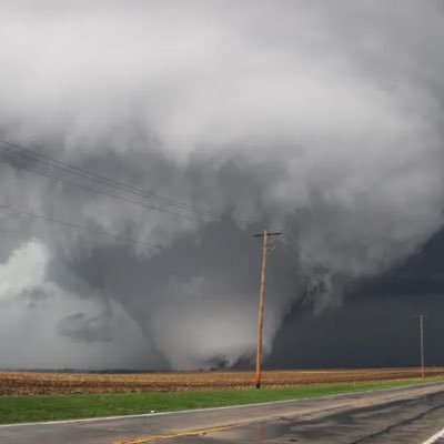
BREAKING: PDS sounding on NAM-CONUS on Saturday! It is safe to say that this looks like a moderate-high risk situation that could unfold on the 27th! Increased low-level shear coming out of due south at +50 kts with STP values maxing to a 10! #okwx #kswx #severewx #Tornado


FRIDAY SEVERE THREAT: ⛈️🌪️ 2 rounds are possible - Friday morning just before dawn and early evening. The earlier round poses a threat for strong winds and some hail. The later round may only be a few isolated storms, but tornadoes can't be ruled out then. #okwx


81° , Dew point 63° and these clouds. Edmond #OkWx 3:20 pm


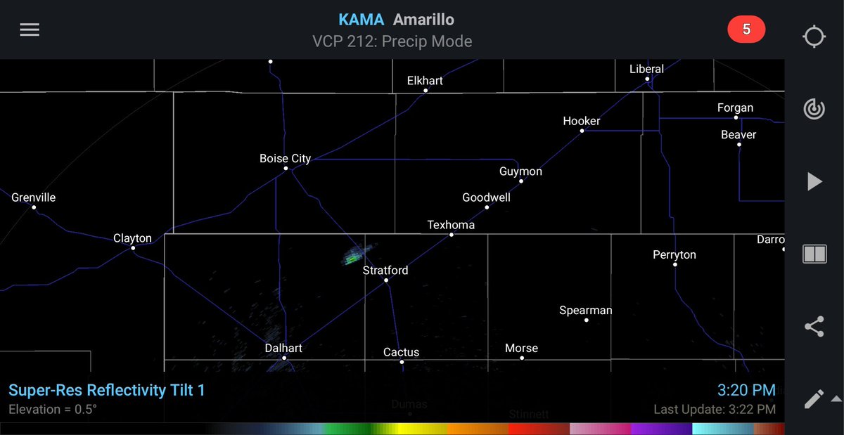


Cumulus field trying to get organized along the dryline in the northwest Texas panhandle as of 3:20 PM. View from Channing, Texas looking north towards Dalhart. #txwx #okwx #nmwx @StormSearch7 @ABC7Amarillo


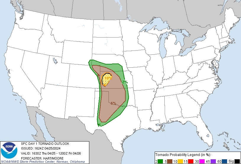
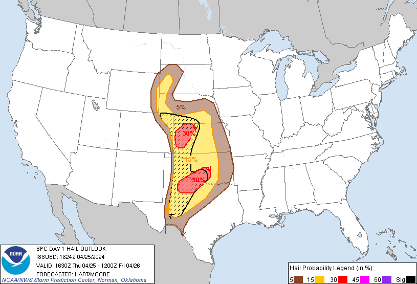
#SPC Day 1 Outlook #Enhancedrisk for #OKwx #TXwx #KSwx Main hazards are Very large hail and A few tornadoes (some STRONG). Other places in risk are #SDwx #WYwx #COwx Remain on guard for potential severe weather #Tornadoalley #tornadoseason


D1 #EnhancedRisk in S and W #TornadoAlley esp #GardenCity,#Goodland,#ColbyKS,#OklahomaCity,#Norman,#Lawton,#Moore,#Altus,#Chickasha,#DuncanOK,#WichitaFalls,#VernonTX 10SIG #Tornado/30%#Wind/SIG #Hail risks #Wxtwitter #SPC #SevereWX #TXwx #OKwx #KSwx #OKC #OKCwx #NEwx #COwx


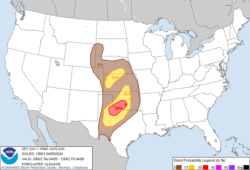

D1 #EnhancedRisk in S and W #TornadoAlley esp #GardenCity,#Goodland,#ColbyKS,#OklahomaCity,#Norman,#Lawton,#Moore,#Altus,#Chickasha,#DuncanOK,#WichitaFalls,#VernonTX 10SIG #Tornado/30%#Wind/SIG #Hail risks #Wxtwitter #SPC #SevereWX #TXwx #OKwx #KSwx #OKC #OKCwx #NEwx #COwx https://t.co/ffx9y6b3gq


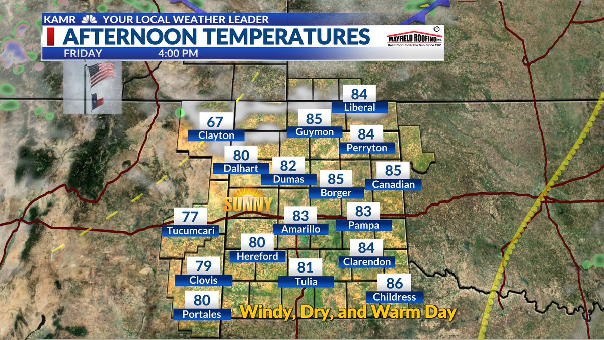
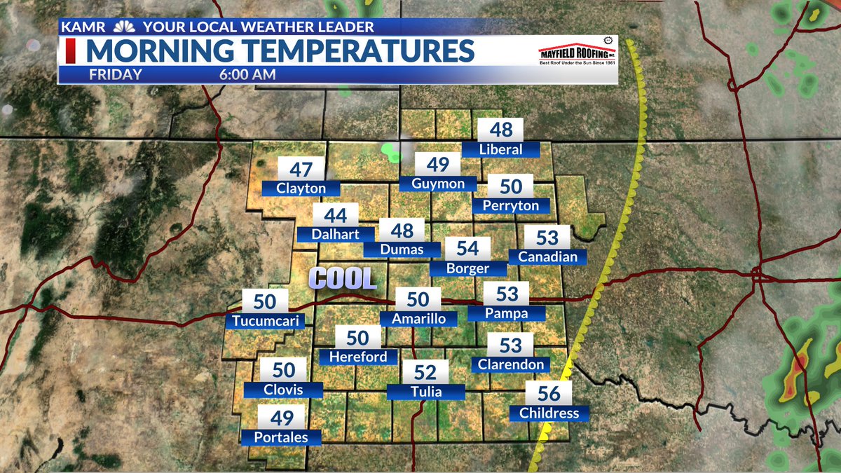
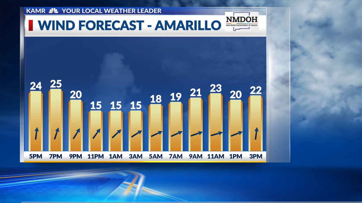
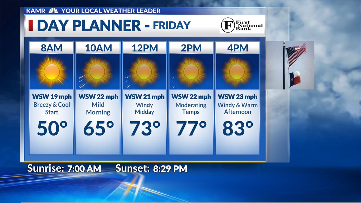
Friday's Forecast - Windy, Dry, and Warm @JohnHarrisWx @KAMRLocal4News #MYAMARILLO #phwx #kswx #nmwx #okwx #lubwx #txwx

Severe weather today for portions of central and southern plains #wxtwitter #wxX #severewx #severe #tornado #kswx #cowx #newx #txwx #okwx The SPC has issued a enhanced risk of severe weather for portions of central and southern plains


18Z HRRR Showing a decently capped atmosphere Saturday hints a EML for the most part limiting any potential strong convection keeping the atmosphere primed for tornnadic supercells.. This is not the look you wanna see Saturday could be our first big tornado day. #okwx #wxtwitter


Oklahoma friends, watch this four minute weather forecast for tonight through Sunday is worth watching, especially if you’re hosting or attending an outdoor event on Saturday, . #okwx youtu.be/M5-P8_uVsgg?si…


Okoboji Weather @okwx
715 Followers 2 Following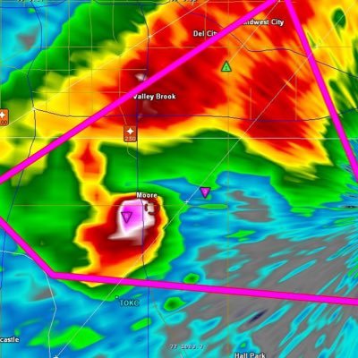
Oklahoma WeatherNet @OKwxNet
271 Followers 46 Following Gary Mann | student of meteorology | storm chaser | severe weather updates for #Oklahoma
OKWX Nerd @OkwxNerd
139 Followers 107 Following Amateur radio operator and NWS Advanced SKYWARN spotter. Keeping you updated on weather in and around Tulsa. 73~
Braxton Banks @BraxBanksOKWX
1K Followers 828 Following Interested in all things weather! Originally from Joplin, MO. Production Assistant for @FOX23. Contributor for @torarchive. Owner of @OKSVRWXOutlooks. #okwx
Oklahoma Weather Watc.. @OKWXWatch
2K Followers 1K Following This account RT's all NWS offices serving parts of Oklahoma.
Ben Smith 🌪️⛰�.. @BenSmithOKWX
290 Followers 615 Following I Chase Adventure: In the skies, in the mountains, on the trail, in the books. Dad bod, puppy love, street philosophy, hopeless poet.
#okwx Social @okwxSocial
249 Followers 50 Following User reported, user contributed. Send Oklahoma Weather reports using #okwx! Follow @okwxSocial to keep up with current OK weather! Part of @SocialWeatherUS.
Jon Morrow @Mes0M0rr0w_OKWX
1K Followers 2K Following Skywarn NWS OUN Advanced Trained Spotter/Photographer/Stormchaser #BoomerSooner
Vortechs Storm Chasin.. @vortechs_okwx
123 Followers 39 Following Oklahoma Storm Chasers Streaming Live Video! @vortechs_okwx on Periscope

Amber Davis❤️🌪.. @OKWXGirl
518 Followers 2K Following 🌪#StormChaser @skywarn #StormSpotter #Photographer #WeatherNerd 🎵 #RedDirtGypsySoul👱🏻♀️#CountryGirl #Mom 👩🏼💻#Scientist 🌎#GIS #Analyst #OKWX⛈

فحل يمني ال�.. @WHXPi6okwx3vT5O
44 Followers 1 Following أحب الجديه وكره الكذب ماهوه مزاجي طبعي كذا
OKWX Alert okwxTV @okwxALERT
17 Followers 1 Following Oklahoma Weather Alerts from Oklahoma Weather Tracker TV. Be sure to download our free app for more Live Oklahoma Weather Coverage.
ひろみ @Q6FjDMdBnOKwxFV
13 Followers 0 Following
Oklahoma Tiempo Lab @OKwxLabEspanol
10 Followers 2 Following Somos una organización de predicción dirigida por estudiantes, en @UofOklahoma en Norman, OK.
Damon Lee Blair @Rush92OKWX
280 Followers 886 Following I'm a skywarn spotter been spotting since 2014

ま な り @ODYPU5qk8okwx2X
10 Followers 6 Following (🏫)jc1 (🎂)0630 (🎾)ソフトテニス部 (🔥)前衛 (💓)Fischer's んだほ ︎☺︎/かずゆい🚗🐧/ クレヨンしんちゃん💞/ tennis関係⚡️ (🌈)フォロバ100!!好きなものが一緒の方是非!❤
Adam @okwxAdam
35 Followers 45 Following
okwx678 @okwx678
24 Followers 39 Following

Shawn Mitchell @SMitchellOKWX
25 Followers 32 Following 🎣Crappie Fishing🎣 Shank Em' and Yank Em' Pro Series Jigs 🇺🇸 Tying Jigs 🇺🇸 🎣Shootin' Docks🎣 🌪 Storm Chasin' 🌪 🏁Dirt Track Racin🏁

عطاءات العل.. @Tq1UYIr08pdOKWX
22 Followers 0 Following
すずきのけんた.. @EwqlBuMmrBrOKWX
25 Followers 38 Following
OKWXUpdates @OKWX_Updates
23 Followers 25 Following Frequent weather updates will be posted here when severe weather is possible and/or occurring. http://t.co/vDZB9TR7jh
Colby Ward @ColbyEffect
6K Followers 3K Following Storm chasing for KNWA/KFTA NBC/Fox (NW Arkansas) @Velocity_wx and @LiveStormsMedia. Oklahoma Alumnus. Real Estate Broker. #ARWX #OKWX #Colbyeffect #AFOL #Lego

Brandon Wholey KJRH @BrandonWholey
3K Followers 3K Following AMS Certified Meteorologist #699 | 2 News Oklahoma. Cert. Drone Pilot. @lyndonweather alum. 16 years forecasting on live TV. 9 years in Tulsa. #OkWx #2NewsOk
OKWXAuthority @okwx_authority
25 Followers 35 Following Your source for the most accurate forecasts in Oklahoma. Whether it's rain or shine, we'll keep you updated on Oklahoma's changing weather!

William Cole @WilliamColeOKWX
45 Followers 292 Following Christian, 4th Generation Oklahoman, Weather Guesser, Alt-Rock & EDM Fan, US Navy Veteran.
Sammy Brence @skywarngeek
344 Followers 233 Following #Marvel Fan. #Cigar Enthusiast. and #freemason also a Storm Tracker with @news9 #okwx @sammyboy405 for IG. Opinions posted are my own and not of my employer(s)
حسن @cJ6bOkwxSaIq4fV
77 Followers 215 Following بی اعتنایی به سیاستهای زورگویانه شرمی به بار می آورد که اثرات آن در کتابهای تاریخ آیندگان ثبت خواهد شد پس درس عبرت نشو بلکه الگوی آیندگان واجداد خود شو....
わさび @ayGF8zhtkdnOkwx
1 Followers 51 Following
OKwx.today @OKwx_today
27 Followers 72 Following Curated #Oklahoma #weather newsfeed. Mention @OKwx_today in your tweet to get featured


沢田直人 @pc486OKWxFnxwXn
21 Followers 71 Following 趣味はゲームです。龍が如くシリーズやバイオハザードシリーズ系のアクションが好きです。後、AKB48が好きです。気軽にフォローしてください。よろしくお願いします。

เอกพล814017 @r1vqOKwxGbM3PO1
4 Followers 12 Following 😊มีแค่ตัวจะกลัวอะไร..แพ้ก้อแค่ขาดทุน..ชนะก้อกำไร..


Lance Maxwell @lmaxwell11
682 Followers 638 Following Finance MBA grad / Modern utilities enthusiast @originutility / #OKwx nerd / #AvGeek / Golf Nut / #ThunderUP #BoomerSooner / Tweets and opinions are my own


. @OKwx5
1 Followers 1 Following
金泰亨 @wOKWxOw1kMAHTE1
2 Followers 10 Following
ポンコツ @4iJejQkI7bOKWX9
32 Followers 114 Following
豬. @7OKWxQJvisOQkO1
0 Followers 0 Following

psnwk @OkwxH1yiTisaIb3
2 Followers 10 Following
Каролина @2bUgYYuOKWx1kbO
1 Followers 4 Following
コオロギ @wOkwx2hw8z42069
33 Followers 17 Following
@02ubOKwx5tp7NhH
13 Followers 64 Following

AS @N9OKwxGUYVagB4Z
0 Followers 0 Following
2 @Okwx8xycMvYNRQ9
0 Followers 3 Following
ธนโชติ �.. @tmkltVvridyOKwx
8 Followers 24 Following
就活ちゃん @zF4OKwx70bAZXQP
0 Followers 0 Following
아뭐어쩔 @YOCrCQsQuf8OKwx
1 Followers 0 Following
อารักษ์.. @SwSkzgzKG4OKWX5
0 Followers 0 Following
okwx @okwx2
12 Followers 130 Following
بنت الدوله�.. @Td3OKwxVQ4ilLHp
2 Followers 0 Following • نبذههـۃ ⊱ ؏ــٓندما تصـل مس̲ٓستـواى ، سོسنتحدث עحقـاً ، 🙂🍕 ٰء !
山田唯人 @YzFgZ6VzkdOKwxL
12 Followers 21 Following
اا اا @LSD0MT0O6Okwx9R
0 Followers 0 Following
唔唔 @rRgG6shJd33OKwx
0 Followers 5 Following
Darryl Santa @Darryl8okwx
3 Followers 0 Following
銀 @hVUs5p0utJ6okwx
7 Followers 81 Following 趣味垢/テラリア/スプラトゥーン/スマブラ/荒野行動やってます!フォロバ100% 漫画も好きです!無言フォローごめんなさい🙇♀️🙇♀️
Deirdre Vosquez @7okwxDeirdre9
2 Followers 0 Following
JDubz @OKWxJDubz
2 Followers 0 Following
りんたろう @56lqzljOkwxK7oL
0 Followers 0 Following
裏垢 @okwxLfw6ZQb9Q14
0 Followers 0 Following
クローバー @egApOkwxXqiyGuw
0 Followers 7 Following

むーんむーん @Y0R9qOKwx2KJgBu
0 Followers 0 Following
わくわく @okwxAki22VAlOrm
0 Followers 0 Following
Todd Rasmuson @ToddOKWX
5 Followers 21 Following
लसमण सि�.. @gOKWxIpprz5Kowp
3 Followers 0 Following
حسي @tsRBw6okwxNPkIx
7 Followers 55 Following
巅峰狗轩2016版 @Wim5zOKwxC29621
0 Followers 1 Following
لٰــوُلٰــ�.. @qOkwxASK0MD1Z35
0 Followers 1 Following
Mike Brown @C2nqBEjdMtOKwxT
3 Followers 0 Following

。 @OKWx9OWNFejC5vn
6 Followers 17 Following
Roxie Boxx @roxie1okwx
1 Followers 0 Following
김나현 @2OkwxSKF3rc5Lo5
0 Followers 0 Following

محمود @rXeN8OKwxOdX7aD
0 Followers 0 Following
さか @xJ9hEcOKwxXZPge
0 Followers 0 Following
نور نور @OKWxL9vONY3nGcn
0 Followers 0 Following
橋本由美子 @lgVmOkwxFujyNsA
2 Followers 7 Following