Search results for #arwx

Gorgeous full moon tonight. #arwx @ToddYakoubian @GarrettLewisNWA @CharlesPeekWX @NWStulsa


AWESOME time-lapse of clouds moving in around sunset. #ARWX #ARStormTeam

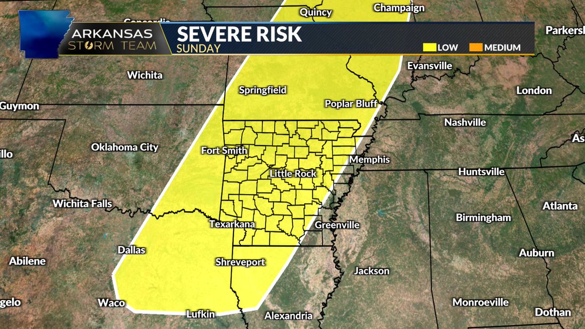
As we get closer to the weekend, there will be a threat of strong to severe thunderstorms. For the THV11 Viewing area, it's Friday and Sunday. Damaging wind, large hail and a couple of tornadoes cannot be ruled out as well as heavy rain. Stay weather aware this weekend! #arwx


Tracking a few showers along the cold front. #arwx

Minor changes to the forecast PLUS the newest storm timing for Friday. It's coming up on KARK 4 News at 10. #ARWX

Coming up tonight after the 10 PM news, we're going to make sense out of this Day 3-7 hazardous outlook "mess" during a social media live weather update. Tune in for the latest discussion on our weekend severe weather potential at around 10:40 PM. #ARwx


How about this for a sunset time-lapse from Lincoln?!?! HAYYYY QUE VUELTAAA QUE VOLIN QUE VOLAAA Total Lion King vibes! These @AxisIPVideo cameras are incredible! #arwx


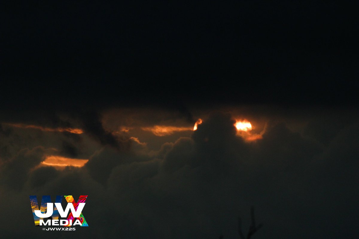
Beautiful sunset popping out of the clouds over Fayetteville! #ARwx @weatherdan @wxpeytonlangfrd


Beautiful sky over @CityofConway! Rays of sunlight coming through the clouds! #arwx


We have a highlighted risk for storms FRI-SUN across NWA. Be aware there is a potential risk during that time, however, I’m not getting too far into this forecast yet, as there’s been so many times this year for NWA where models burn us by day-of said event. Stay tuned #ARwx

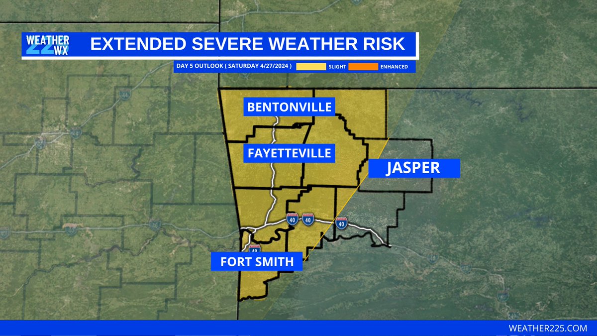
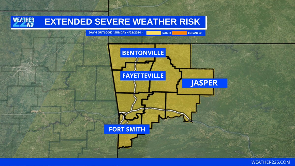
We're keeping a close eye on two threats for severe weather... One will come Friday across western AR. The 2nd (and perhaps the most significant) will come Sunday, which involves most of AR. Damaging wind, hail and tornadoes will be possible w/ both rounds. #ARwx


ARwx @ARwx
4K Followers 185 Following Be Informed. Be Prepared. Signal boosting the best Arkansas weather sources to keep you safe. #ARwx (managed by @tsudo)
Hail's Angels ARwx @HailARwx
342 Followers 13 Following Welcome to the Twitter feed of the Hail's Angels Storm Chasing Team. During bad weather expect live tweeting of the chase.
#arwx Social @arwxSocial
370 Followers 51 Following User reported, user contributed. Send Arkansas Weather reports using #arwx! Follow @arwxSocial to keep up with current AR weather! Part of @SocialWeatherUS.
KATV News @KATVNews
181K Followers 624 Following #KATV Channel 7 #News #Arkansas #arwx #KATV7 https://t.co/unQDiolb4K
ℛ ِ @4arwx_
51 Followers 46 Following


ARWX @1_h3art
41 Followers 91 Following
✨arwx✨ @xcalmxt
479 Followers 1K Following 5sos af ✨17.03.16 @danielsahyounie followed✨19.03.16 @ROOM94 followed✨20.03.16 @AshleyNHorne followed✨12.06.16 @bennymcnugget followed
JEN @UpnAbP3bRa7arwx
17 Followers 13 Following

ًًWx_99z @arwx_99z
28 Followers 72 Following كُن دائـماً المُــلفت الذي لا يلـتفت .. || أجد في الرسم حياةً أُخرى 💓| SCD_er
ARWeather Today @ARWxToday
49 Followers 33 Following
公🍑0 @ARWxKlqK79D9xFH
76 Followers 365 Following 25-180-65-0-17,🍑桃臀,大吊公0, 分享和交流,不定时更新,关注,带照必回私信 聊天带照,口嗨勿扰
アニー @bHoARwx1pLO6ZIA
0 Followers 4 Following
Patrick Ellis @PatrickEllisWx
9K Followers 3K Following Meteorologist @WMCActionNews5 〽️| Formerly: WABG, WNCT, WECT, WLBT |🏳️🌈. Opinions, views = mine. RT ≠ Endorsement. #mswx #tnwx #arwx #hailstate #geauxsaints
ً @arwx50
28 Followers 0 Following
さーこ @arwxH0gkF9woxgT
2 Followers 13 Following


خالد @ARWxB9zVG3oGDF4
32 Followers 114 Following
Pat Walker 🌨 @PatWalkerWX
9K Followers 3K Following Christ follower, husband, father, & Hog fan. Emmy Award Winning Met @KARK4News & @FOX16News since 2013. RT≠Endorsement TAMOO. #ARWX #ARStormT #WPS
A. @arwx73
10 Followers 6 Following

شهاب @Iod6ArwxOeSJgCS
18 Followers 108 Following
development @fARWX2s578cE1RZ
1 Followers 2 Following


Rachel Coulter WBTV @Coulter_wx
6K Followers 1K Following WBTV Meteorologist. muwx/muwbb. Psalm 23:3. #wiwx #ncwx #pawx #arwx #mswx #ncwx/#scwx
Arywx @Arwx123
24 Followers 195 Following
Joel Young, CBM @joel_off_air
15K Followers 5K Following 3x Emmy Nom Meteorologist @KARK4News & @FOX16News | Born & Raised in the MS Delta | Tweets=Mine RT≠Endorsements | #ARStormTeam | #ARwx
Jake Dalton @jdaltonwx
2K Followers 619 Following Meteorologist at @3onyourside | #HailState Alum | Dog Dad | Louisiana Born & Raised | #TNwx #MSwx #ARwx
arx:4 @4_arwx
2 Followers 8 Following

Colby Ward @ColbyEffect
6K Followers 3K Following Storm chasing for KNWA/KFTA NBC/Fox (NW Arkansas) @Velocity_wx and @LiveStormsMedia. Oklahoma Alumnus. Real Estate Broker. #ARWX #OKWX #Colbyeffect #AFOL #Lego

ゆと @ArwxU2asFrImC6s
213 Followers 486 Following

د نجم الدين .. @bArwx4nfe4pVomt
32 Followers 697 Following

كٰہٰٰٖٖصہٰ�.. @oMtZo2arwxOeeTl
4 Followers 35 Following ⠀ ⠀ ⠀⠀⠀❞IRΔQ 🇮🇶|| 20 Y.O ❞ ﴿سيفرجها الله كأنها لم تضيق بنا يوما.🤍 ﴾ ⠀⠀↬ ❈⁽ шεʟcσмε тσ мч вяσғ ❁ ⠀ ⠀⠀ ⠀⠀
ابوسالم حدي.. @M9jARWX7oe3z2FU
21 Followers 84 Following ابوسالم للسكراب والخردة اشترى الحديد وجميع الخردوات سكاكا الجوف 0503595949
裏垢 @arwx0Ilzld4Xarf
2 Followers 4 Following 裏垢︎︎︰愚痴垢:病み垢︰愚痴ツイ︰病みツイ︰陰キャ︰中3女︰お友達欲しい︰陰キャ︰無言フォロー失礼します︰自発苦手︰エロ系✖︰すごいツイートする︰話しやすそうな人は絡みます︎︎☺︎
Arwa @arwx99
3 Followers 88 Following

Mark Cartwright @03msc
542 Followers 562 Following Sinner saved by grace. #ARWx geek. Skywarn Spotter. Ham radio: KD5BVX. College Facility Manager. Church Media Guy. Tweets are my own views.

amber widmeier @arwx2
0 Followers 133 Following
Byron wood @x02xARWx01x
9 Followers 11 Following

อยู่เฉย.. @npARWxRo2XeUMm5
1 Followers 16 Following

LouiseBeerbohm @CWcArwx3ui3427u
0 Followers 0 Following
김연희 @WeNALR5QVDyARwx
1 Followers 1 Following

Arwa :) @9_Arwx
2 Followers 5 Following
علوش مارتن @g4U9ARWX6KN0y4T
0 Followers 3 Following

arwx @xrwx_0
0 Followers 36 Following
Tony @arwx3
18 Followers 130 Following
大白肉孜 @i86XlARWxFCZLGY
0 Followers 5 Following
مختار الخيا.. @dO4VwOFbX1zARWX
2 Followers 14 Following

7わーくあうと @ir29xARwxAyKCdh
0 Followers 1 Following


Некто @IiARwx09vDT5Z8G
0 Followers 0 Following
AR . @arwx_i
0 Followers 14 Following
Jamiya Slobodan @jamiya9arwx
3 Followers 0 Following
ARWX @cARweather
5 Followers 12 Following Providing weather information for Central Arkansas. Send weather pictures in DM. Weather is a hobby, I'm not a professional. Send weather pictures in DM.
제이홉 @ArwxOCPqWLbBC1V
5 Followers 35 Following
yu @arwxLs1d4Lv1pib
0 Followers 0 Following
和山啓二 @8Arwx9
0 Followers 1 Following
ARWxAND @ARWxAND
0 Followers 1 Following

xXxARWxX @xXxARWxX
2 Followers 38 Following


سليمان @KFoaJaAMeCoARWx
0 Followers 0 Following


山中一成 @arwxBqpltORTBWl
0 Followers 0 Following
حسوني ماستر.. @r8w5ARWxEMVimYS
0 Followers 10 Following

木头人 @ARwxSmtngcXyJkm
0 Followers 5 Following

ข15 พิมพ์.. @MjyARWx1wM45949
0 Followers 0 Following

أبو الملاح �.. @ZAew7gguARWxA03
0 Followers 21 Following
島田亮 @A5G3cvXy0ARwxO8
0 Followers 0 Following
渡邊寿樹 @s9Arwx1cge92106
0 Followers 1 Following
リヴァイ アッ�.. @iMXK0En0Y1nARWx
7 Followers 18 Following (☝ ՞ ՞)☝ウェェェェェェェェェェイ!!!!!!キチガイのふくしまです!(っ'ヮ'c)ウゥッヒョオアアァアアァよろしく!

Arw @_Arwx_
0 Followers 23 Following
34zgq9o7yygxdd @pj57arwx2p
0 Followers 0 Following
Arwx @hegi362365
0 Followers 1 Following
じゅきや @ArwxJHAUdYG8ASD
0 Followers 1 Following
ももすけ @36DGmyl7Qa2Arwx
1 Followers 0 Following