Search results for #iawx
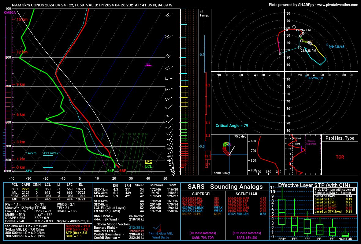
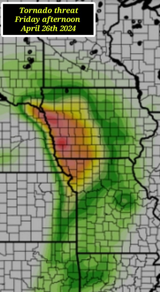
Eastern Nebraska on Friday is where I would start the day on Friday. 200+ 3cape = cheat code. Early in the day looks a lot like last weeks setup that produced many LP-esque tornadoes. Then later before nightfall better be in western Iowa. #newx #iawx

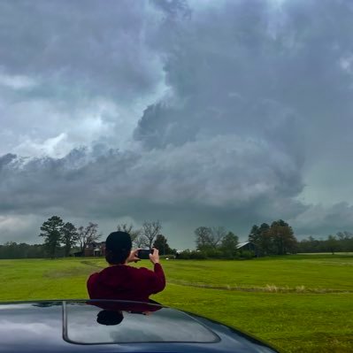
It's morning over Sioux City... here's a look outside. The airport is reporting sunny and 49. #iawx


Looking ahead at the morning for Sioux City... get the latest forecast anytime at iowawx.com/forecast #iawx


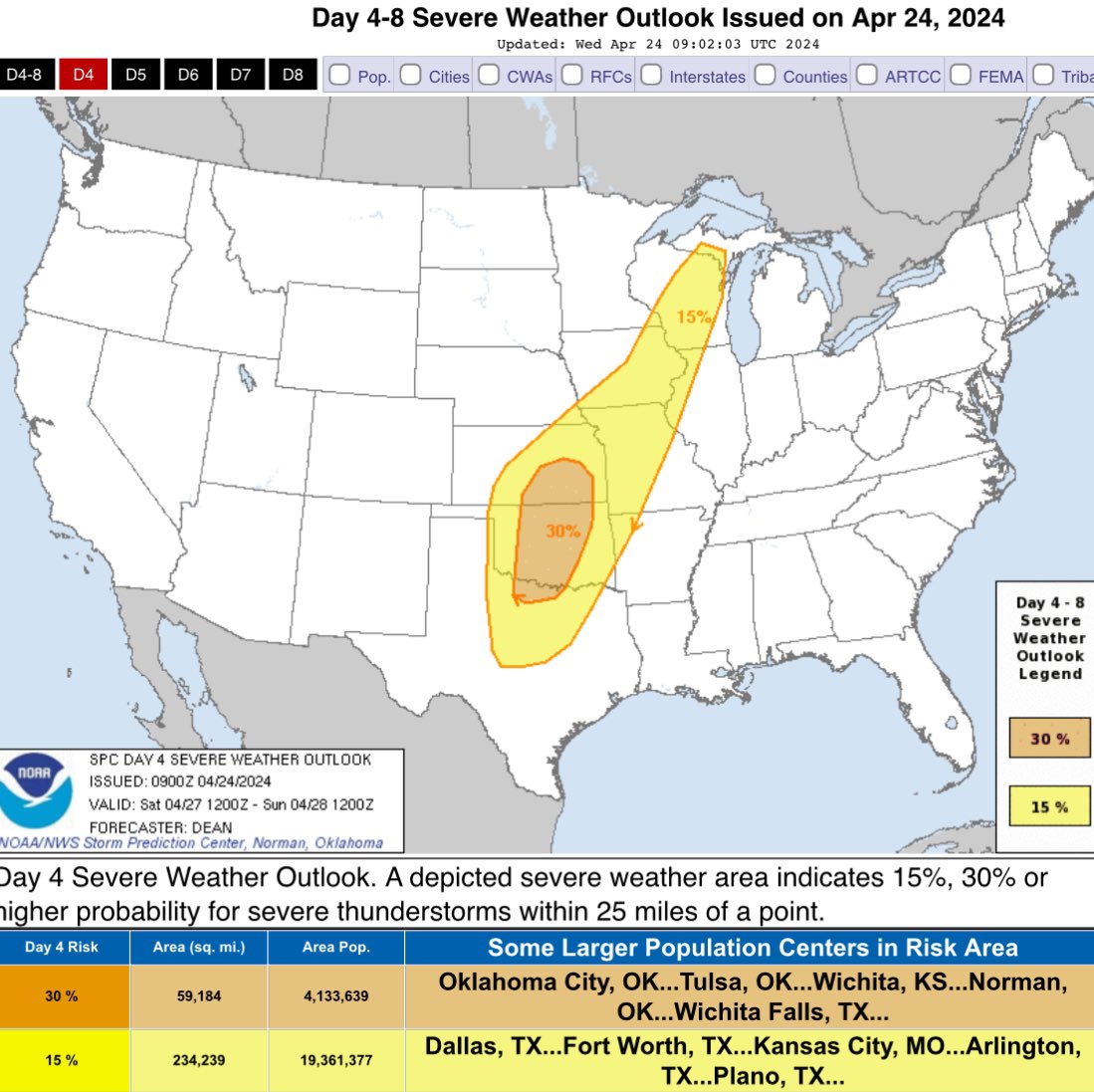
Time for some good old multiday severe threat action as we head into peak tornado season. Always have a plan incase you are under a warning and stay weather aware. #wxtwitter #iawx

It's Wednesday. Here's how temperatures are looking: ranging from 29 in Mason City to 46 in Keokuk. Have a great day! #iawx

🧳🛻Today we load up the vehicle to trek to Ottumwa for another round of spotter training this evening. We hope to see at least a few new faces and sign up some new spotters! Remaining schedule and additional info: weather.gov/desmoines/stor… #iawx


Wake Up Weather: Skies are clear and temperatures are in the cool 30s. Des Moines is warmest in the mid 40s this morning. #iawx


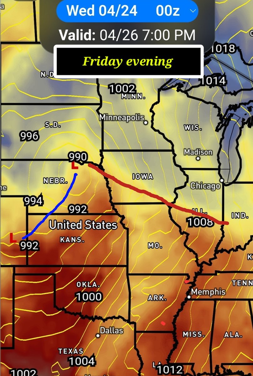

[2] to erupt along the cold front late Saturday afternoon. Severe risk will carry over Saturday night and again on Sunday as the main surface low moves over the state. This is NOT the weekend to mentally check out on staying up to date with weather information. #iawx
While FRI continues to be of interest over West/SW #iawx for severe weather, SAT continues to uptrend as well as the cold front associated with FRI’s system never really clears Central Iowa. Second trough & jet streak right on the heels of FRI’s system will likely cause storms…


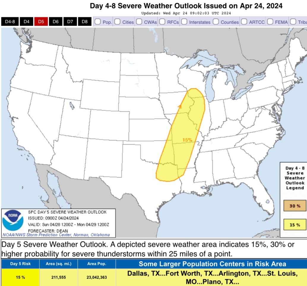
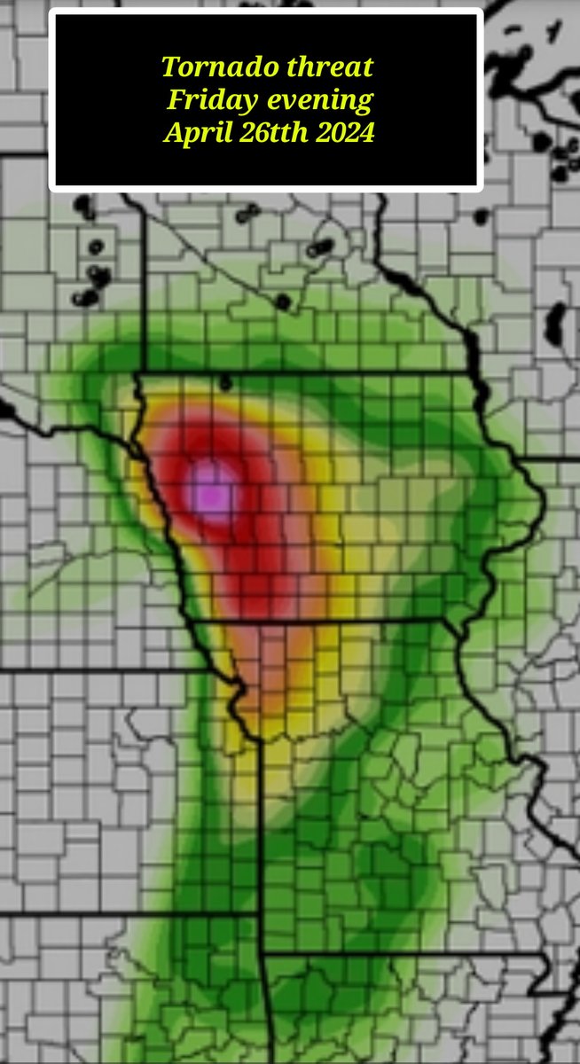
Severe weather remains in the forecast for Friday as a strong system lifts into the Midwest. Strong to severe storms are expected in the afternoon and evening hours. The main threat remains large hail along with a few tornadoes. Be weather aware Friday! #iawx

Yesterday we took a break from forecasting and instead shared and learned from each other in a seasonal-readiness training day. It was a rare time ALL of our staff were together. We are so proud of that!🙌 Thank you @NWSPaducah for handling our forecast yesterday! 🤝 #IAwx #KYwx


The sun is coming up and it's going to be a beautiful day in eastern Iowa! Temperatures will be cooler than yesterday (this morning & this afternoon) but much less wind! cbs2iowa.com/weather #iawx

Wednesday Sunrise: Clear skies as the sun just lifts over the southeast sunrise this morning! It will be a nice calm day! #iawx


FOLLOW Louisa Ia WX @IaWX
5 Followers 0 Following
#iawx Social @iawxSocial
200 Followers 58 Following **CURRENTLY IN BETA** User reported, user contributed. Send Iowa Weather reports using #iawx! Follow @iawxSocial to keep up with current Iowa weather!
Iowa Weather Center @iawx_center
266 Followers 157 Following We share weather forecasts and in-depth weather analysis for the state of Iowa. We cover all types of weather including severe weather and winter storms.


سااااااااا�.. @jumtrIAwxDWWK3z
267 Followers 822 Following


N. @iawx9
8 Followers 5 Following


IowaWeather.com @IAStormChasing
23K Followers 3K Following The largest online Iowa weather network. Bringing you the best weather coverage devoted only to online viewers. #iawx

MitchellCoIAWX @MitchellCoIAWX1
32 Followers 154 Following

ばんく @7iawxXL9FCyGKRy
3 Followers 12 Following
إسحاق طالب @TPTuIAWxEohiC80
28 Followers 55 Following أشهد أن لا إله إلا الله وأشهد أن محمد رسول الله
رسول @Y8LMyWMRtFhIAwx
4 Followers 7 Following
نواف العلوي @5iawx
4 Followers 27 Following

!! @t0iawxKNPd9REnA
16 Followers 2 Following
Auto Outlaw Jr @xOutIawx
55 Followers 254 Following Designer and rap artist : Austin Underwood https://t.co/UrJSFD4BQs homies: @m9creates @oToxn https://t.co/HidrJv0z8d


ヤ・ク・ソ・ク @VRdVTDtJR3IAWxC
84 Followers 120 Following こんにちは! 中学生です、テニス部です!沢山の人と仲良くなれたらと思ってます! OnePieceとドラえもんとか好きです!
Will Mittelsteadt @WJM_IAWX
1 Followers 2 Following
meuzinho @outIawx
3 Followers 4 Following
Austin @iawx515
2 Followers 82 Following

ريوف محمد ا�.. @OEtIAwx3Q1U5LZa
7 Followers 59 Following أحياناً تكون الرسالة بَلسم مِمن نُحب، لكن لا تكون بديلة لصوت من أحببنا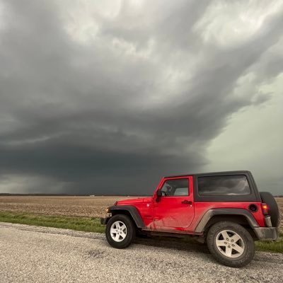
Noah Emmert @noah_emmert
564 Followers 379 Following I am a storm chaser, majoring meteorology, (#iawx) in @CornbeltChasers, a band guy and a student at College of DuPage, 21 years old. Tornadoes : 4
Warren IA WX Alerts @WarrenIAwx
5 Followers 0 Following
تالا عامر د�.. @AXvhIAWxCDEPQbL
1 Followers 3 Following


✨ @m2spMPaIawxSrST
1 Followers 10 Following

Grant Young @grantyoung72
1K Followers 445 Following Proud Iowan, @stanhopestate, sports aesthetics enthusiast, @niacc cafeteria grilled cheese champion, husband, #iawx spotter


จำลอง @DyIAWxJ2FDDpoBP
5 Followers 111 Following
عبير @iawx_r
5 Followers 3 Following
محمد @Y3zDwJKKDpnIAWx
2 Followers 18 Following
바그란 @Y1suG3r3wqfIawx
1 Followers 4 Following
餡蜜丸 @OIPQqf62Iawx15m
51 Followers 67 Following 好きなもの(超大雑把)→BUMP/amazarashi/シャドバ/パズドラ/オーバーウォッチとかとかとかとか! 趣味合う人いればいいなぁって思っています!
秋永好晴 @RbJk59ih5Iawx3F
3 Followers 12 Following


バスター @atmVX3Iawx09Zct
0 Followers 0 Following

Ivan Ang @iawx19
4 Followers 18 Following
The Weather Guy @IAwxGUY
1 Followers 8 Following Live for extreme weather. Based in the Iowa metro area. Wanna-be meteorologist turned storm chaser.
芳賀久夫 @rWANwm1qf7aIAWX
0 Followers 2 Following 1昨年まで店舗関係のデザイン及び管理者としてPOLOラルフローレン/ジョルジオアルマーニなどに従事してましたが、昨年胃癌を発症して手術は昨年11月二無事に成功しましたが臨床検査に参加しており肝臓二転移せてましたので現在点滴抗がん剤治療江尾しております桂川順調で鵜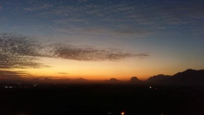


. @ZuYiheIawxZsx08
1 Followers 105 Following Dream smp fan Mostly sapnap fan -.- She/they/he Bisexual Ofc supports LGBTQ+🏳️🌈 BLM✊🏻✊🏼✊🏽✊🏾✊🏿
عبود @Qpy6Gnpc6S7Iawx
0 Followers 0 Following
HUBYDZ @qwilIAwxR0Q5kqJ
0 Followers 5 Following
ラーメン @BcyOszFoTAxIAwx
0 Followers 14 Following
عمارالرماد�.. @xj6IAwxJ4Fts1Hl
4 Followers 2 Following
鐏裟曦 @fIAWx3s2ceVbSa7
3 Followers 93 Following

اسلام الاسن.. @IAwxHrsfrNvQMCZ
0 Followers 34 Following
すーちほ @MZrIAWx1f9ztoO6
0 Followers 0 Following
Дакария Теп.. @IAWx6RmDios11Yw
0 Followers 5 Following
حمد الحربي @IAwxSDyuAbOrFRg
6 Followers 76 Following


Дарина @Iawx513jPPc5yLl
1 Followers 6 Following
هانى عبدالح.. @7iawx01CO1e0C5
1 Followers 62 Following
عباس شريف @IAwxGD5BVnFFb7z
7 Followers 20 Following
𝕊𝕪𝕣𝕚𝕒�.. @7iawxLwNp7ID0MT
2 Followers 0 Following
سما @KBemE46liO0IAWx
2 Followers 0 Following

مهاجر من بل�.. @uSykszOQxIAwx4e
1 Followers 26 Following
Isaí vázquez @iawx245
1 Followers 0 Following
Oliva Laughner @Yvette_iawx
1 Followers 0 Following
ふみ @Iawx6ifhc5rXEYQ
2 Followers 4 Following
серёга степ.. @yintpSmIAwx1HrC
1 Followers 0 Following
K @ztAfaIAWxGzmRHY
0 Followers 0 Following
ابوايه @IAWxNU21pRDxlGf
1 Followers 55 Following
بيبو براك @43wvSxeXrn3Iawx
5 Followers 46 Following
Камен Младе.. @JMiwJbdIAWX0xxG
1 Followers 0 Following
تركي @IawxDtHAHwlCqhR
1 Followers 0 Following
أبو مشتاق ع�.. @mZhIAWxBSidojzH
2 Followers 52 Following
정여진 @o7pagzCxPQ0IAWX
1 Followers 0 Following
小野寺昴太 @iawxLXzGVBm1Bn1
2 Followers 0 Following
pppp @FYBfIAwx3YhpdSd
0 Followers 0 Following