Search results for #mswx

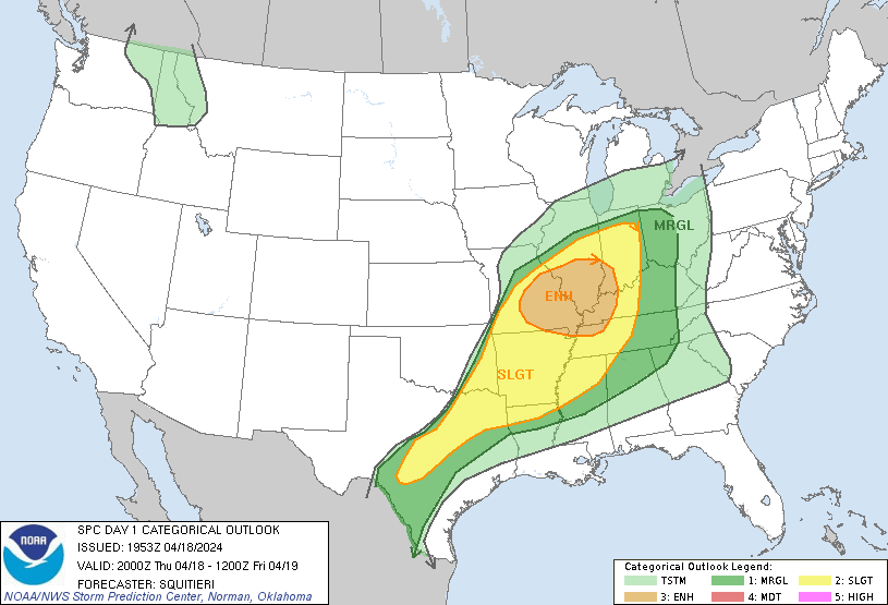
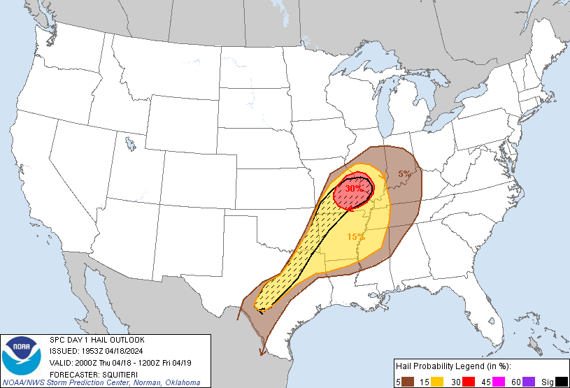
NE Louisiana and Central Mississippi The threat for isolated large hail and damaging wind gusts has increased across northeast Louisiana and central Mississippi. Watch issuance is possible. #mswx #lawx #arwx


#SevereThunderstormWatch possible in C #Mississippi, SE #Arkansas, NE #Louisiana esp #JacksonMS,#Ridgeland,#PearlMS,#ClintonMS,#BrandonMS,#MadisonMS,#MeridianMS,#Vicksburg,#Starkville,#Bastrop,#MonroeLA #Wxtwitter #SPC #SevereWX #LAwx #ARwx #MSwx #Hail #Wind

#SevereThunderstormWatch possible in C #Mississippi, SE #Arkansas, NE #Louisiana esp #JacksonMS,#Ridgeland,#PearlMS,#ClintonMS,#BrandonMS,#MadisonMS,#MeridianMS,#Vicksburg,#Starkville,#Bastrop,#MonroeLA #Wxtwitter #SPC #SevereWX #LAwx #ARwx #MSwx #Hail #Wind https://t.co/P2KS2Jax0t


New Severe T-Storm Warning until 4/18 5:00PM for East Carroll, West Carroll, Issaquena. #mswx wjtv.com/weather?utm_me…


The fact that this doesn’t even have a “Tornado Possible” tag on the SVR warning is astounding. #mswx


Some severe (wind and hail) threat may continue for areas along and south of US 82 over the next few hours. @abryantwx in house and watching closely! #mswx
Some severe (wind and hail) threat may continue for areas along and south of US 82 over the next few hours. @abryantwx in house and watching closely! #mswx

3:41pm CDT #SPC_MD 0484 , #mswx #lawx #arwx, spc.noaa.gov/products/md/md…

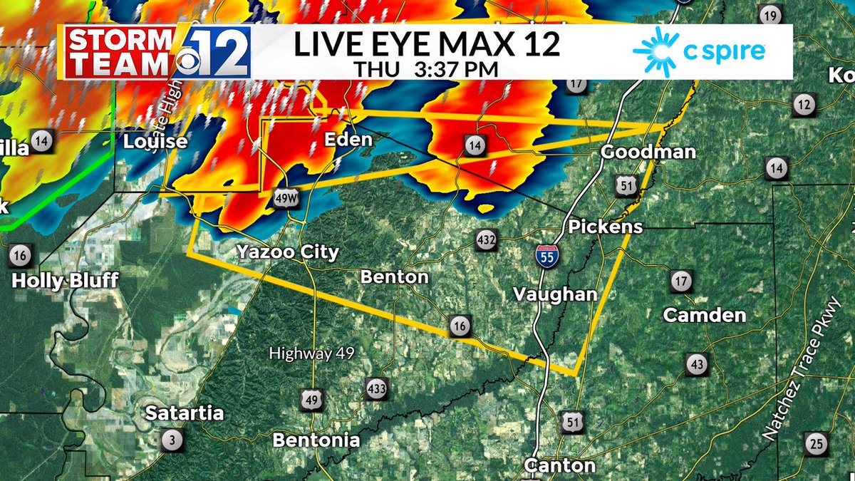
Severe thunderstorm warning issued for Holmes, Madison, and Yazoo Counties until 4:30 PM. 60 MPH winds and 1" size hail are the main threats. #mswx


Radar is indicating the potential for small hail with the storm just southwest of Lawrenceburg, TN. 30-40 mph wind gusts also possible. Not severe warned, but be inside away from windows as the storm approaches! #tnvalleyweather #tnwx #alwx #mswx #weather

New Severe T-Storm Warning until 4/18 4:30PM for Yazoo, Holmes, Madison. #mswx wjtv.com/weather?utm_me…

Storm Factor Inc Severe Thunderstorm Warning for Yazoo County in MS until 4:30pm CDT. Be Weather Aware! #mswx
Severe Thunderstorm Warning for Holmes, Madison, and Yazoo County in MS until 4:30pm CDT. #mswx
We can see the West Point to Loretto storm in the distance on the Arctic Air Skycam Network's Lawrenceburg cam. The storm is not severe but may produce pea size hail and 30+ mph wind gusts, in addition to lightning and heavy rain. #tnvalleyweather #tnwx #alwx #mswx #weather


Severe thunderstorm warning is in effect for Holmes County until 3:45 pm CDT. There is a better chance of hail in this cell as radar is picking up a potential hail core aloft. If this hail falls, we'll also need to watch the change for 40-60mph gusts. #mswx

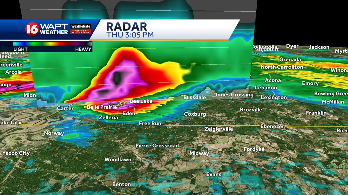
New Severe T-Storm Warning until 4/18 3:45PM for Holmes, Yazoo. #mswx wjtv.com/weather?utm_me…

Storm Factor Inc Severe Thunderstorm Warning for Yazoo County in MS until 3:45pm CDT. Be Weather Aware! #mswx
Severe Thunderstorm Warning for Holmes and Yazoo County in MS until 3:45pm CDT. #mswx
A severe thunderstorm warning has been issued for parts of north Sharkey and Humphreys counties until 3:45pm CDT. Torrential downpours, strong gusts and the potential for hail all possible within this cell. #mswx

New Severe T-Storm Warning until 4/18 3:45PM for Washington, Humphreys, Sharkey, Holmes. #mswx wjtv.com/weather?utm_me…


Sarah @mswx
74 Followers 142 Following Aviation Meteorologist, curler, bagpiper, BSc Env @uofg, DMet @DalhousieU, Maritimer at heart

Cox Middle School Wx @CoxMSWxSTEM
87 Followers 2 Following Providing real-time weather data for Cox Middle School and surrounding neighborhoods
#mswx Social @mswxSocial
181 Followers 50 Following User reported, user contributed. Send Mississippi Weather reports using #mswx! Follow @mswxSocial to keep up with current MS weather! Part of @SocialWeatherUS.
Spring Mills Middle W.. @SpringMillsMSWx
42 Followers 2 Following Providing real time weather data for Spring Mills Middle School and surrounding neighborhoods
佐藤一見 @6Kp3mswxYKu30d6
76 Followers 72 Following
Patrick Ellis @PatrickEllisWx
9K Followers 3K Following Meteorologist @WMCActionNews5 〽️| Formerly: WABG, WNCT, WECT, WLBT |🏳️🌈. Opinions, views = mine. RT ≠ Endorsement. #mswx #tnwx #arwx #hailstate #geauxsaints
gara @mswxChick
144 Followers 104 Following Owned by one calico cat. Luv: wx. clouds. KHwaves. rain. snow. winter trees & skies. cats. birds.
Warm Springs Middle S.. @WarmSpringsMSWx
12 Followers 2 Following Providing real time weather data for Warm Springs Middle School and surrounding neighborhoods
MSWXPhotog @MSWXPhotog
452 Followers 149 Following Photographer, WXgeek, MSU Meteorology grad, husband, musician, E911 Communications Supervisor, and all around funny guy.
Fannin Middle School .. @FanninMSWx
39 Followers 0 Following Providing real-time weather data for Fannin County Middle School and surrounding neighborhoods.
Mabry Middle School W.. @MabryMSWxSTEM
14 Followers 0 Following Providing real-time weather date for Mabry Middle School and surrounding neighborhoods.
McWilliams_MSweather @McWilliams_MSwx
14 Followers 6 Following
🃏 @_MSWx
243 Followers 801 Following
小林明美 @nSmMSwxIkEc3SCi
0 Followers 29 Following
Teresa Mergens @Teresa_MSWX
907 Followers 3K Following ■Nurse 👩🏻⚕️🩺 ■Trained Skywarn Wx Spotter🌪 ■🎶Music/Drummer🥁 🖤Who Dat Nation💛🏈 ■Photography📷 ■Science/Nature🔭
Rachel Coulter WBTV @Coulter_wx
6K Followers 1K Following WBTV Meteorologist. muwx/muwbb. Psalm 23:3. #wiwx #ncwx #pawx #arwx #mswx #ncwx/#scwx
Seminole Middle Schoo.. @SeminoleMSWx
8 Followers 0 Following Providing real-time weather data for Seminole Middle School and surrounding neighborhoods!

MSWxC4NDY @MSWxC4NDY
3 Followers 16 Following Hey people 😁 TIME ZONE: GMT/BST !! Member of MSW! Partners with OWN3D and GMRWEAR!!! Stream Schedule is Wednesday, Friday 9:30am-12:00pm, Sunday 6pm-9pm (ENG)

ともっち @1q55oMswxS26fj3
3 Followers 18 Following
연규 희지 @MSWx2j7l0oKQEw8
0 Followers 0 Following 우리는 기술자가 아니더라도 하지만 당신의 마음이 상했다면, 우리는 그것을 고치는 데 도움을 줄 수 있습니다.
Eric Jeansonne @Weatheric
3K Followers 783 Following | Chief Meteorologist @WLOX | University of Oklahoma Alum | Louisiana Native | Amateur Photographer |Tweets links pics retweets not endorsements | #mswx #lawx
my🚀 @my3741mswx_bnb
0 Followers 0 Following Dedicated to supporting projects that leverage blockchain for social impact and humanitarian efforts.
陌陌 @MSwx136431687
18 Followers 314 Following
Myah Ward @mswxMyyah
10 Followers 30 Following I need some lovin on new years night... anyone wanna hook up? add me at http://go-url.in/8fu
Mike18 @mswx_187
0 Followers 49 Following
𝐏𝐥𝐯𝐬 𝐕.. @R7rGV8vMSWxL4fz
7 Followers 120 Following ~ Freedom loving nationalist || Politics, Culture, Philosophy & Memes.

🏳️🌈Гей�.. @KIMPFB95X4mswxV
18 Followers 58 Following Туц Туц Туц Активный пассивчик к вашим услугам 🌚👌🏳️🌈
محمد عيسى @JEJROIgNu8MSwx6
17 Followers 58 Following وسيبقا نبض قلبي يمنيا لن ترا دنيا على ارضي واصيا

شموخ @5TvMSWxRQ0bR1pw
5 Followers 19 Following
李欣 @mswx5207
39 Followers 619 Following
あ @9HWe18MSWx23523
0 Followers 1 Following
Евгения @DHVyMSwxYvJZh2y
2 Followers 5 Following

الشيخ علي ح�.. @Pk1ro4MSWxRWMT2
5 Followers 17 Following


りゅと❄🍶 @ryuto_mswx
20 Followers 40 Following 成人済20↑。CQL忘羨。原作を先に読んだはずなのに親はCQL。時々文章書いてる。本垢から独立したので関連のお話はだいたいこちら。壁打ちしたい。アイコンは雪永様(@design_meteor)

ابو جودي @MSWxHVUQHgi185S
5 Followers 28 Following
赤西天空 @wMswxIrwjlVyBN4
1 Followers 6 Following
りん @Deby6tHCst5MSWx
2 Followers 20 Following

Саша Руль @7PtMGwMSWx53W7n
4 Followers 59 Following

احمد @Mswx5mLSd65x9hV
1 Followers 3 Following

MSWxPH @MSWxPH
0 Followers 2 Following

( ^ω^ ) @l60r8mswxTR9ZRD
0 Followers 0 Following

ابو كهلان @e7QvMswxHFifX9E
0 Followers 8 Following
Вулодя @HvELwMSWx9b2U8h
0 Followers 57 Following
ابو صلاح @zQWFmbMSWx6IW3m
19 Followers 594 Following

坂口禎彦 @lXtpMaEezXiMSwx
0 Followers 0 Following
نوفممٌبر @ZGKgtyMSWx5AyIt
0 Followers 0 Following
لين @WR26MSwxXAj1juo
0 Followers 0 Following
M2mswx @m2mswx34600
11 Followers 79 Following


زيوني المرش.. @5MSWxN3PKcX7CQQ
0 Followers 0 Following

YAHIA YASIN BNIAN @7cFKfhMSWxQzgut
0 Followers 15 Following الحياة ابسط بكثير مما نتوقع فعشها علئ بساطتها 💚💚👊👊
наталія @Bfx5tbMSwxZ30yH
0 Followers 2 Following
امير الاحزا.. @hOubVddMSwxDZRf
0 Followers 1 Following
макс @kjBXonXxMSWxV1b
0 Followers 0 Following
Григорий @MSWxYWu8GY9S3iK
0 Followers 0 Following
Muath Kkkk @MSWX555
0 Followers 0 Following

RenataGibson @0P4o1MY1wMSwx7M
0 Followers 0 Following
تينا محروس @2HqR1k2XmI7MSWX
5 Followers 0 Following
lily @bfdu953mswx
0 Followers 41 Following Close your eyes, and see yourself, you are clearly visible
Valeria @mswxR3FL3CTZx
3 Followers 0 Following
MsWx Mart @Mahhyoo_
0 Followers 1 Following
민 @IOhMSWX862MG5aw
0 Followers 0 Following
うゆ @MswxRMojic66VRC
0 Followers 0 Following
柳本龍我 @y46MSWxRGH95236
0 Followers 2 Following
Дêβōчķẳ © х.. @mswxUDd9Wp4x8WV
0 Followers 9 Following
Mbaga Walusimbi @mswx2
4 Followers 21 Following
Coralie Dimier @mswx9zrr6w
0 Followers 0 Following
あべ @axNjXz0xc8zMSwx
2 Followers 10 Following
クゥー @msU3lFMe3MswxSE
0 Followers 0 Following
三上小百合 @jHDtzMswxG71480
0 Followers 1 Following
워너블♡♡ @BD3t9MSWxTpyM4r
0 Followers 1 Following


こころ @0nPk1MSWxZvYNxO
0 Followers 1 Following
クラウン @O3MSWx3lqAeJran
2 Followers 2 Following