Search results for #wvltwx

Good morning! Scattered rain and storms return today. Who's loving these warm temperatures? I feel like we skipped spring and went straight to summer!! #FirstAlert #tnwx #wvltwx

Whew! It's windy out there! Gusty showers continue over the next couple of hours. I highly recommend the rain jacket vs. the umbrella this afternoon! #FirstAlert #tnwx #wvltwx

The Severe Thunderstorm Warning was extended into Knox, Jefferson, Union, and Grainger County until 5:30 p.m. The main threat is gusts up to 60 mph possible. Small hail is possible as well. #FirstAlert #tnwx #wvltwx

Good morning! Check out the snow on the mountaintops! It's pretty to look at but I'm ready for the 70s to return. #FirstAlert #tnwx #wvltwx

Good morning! Who let Old Man Winter back into East Tennessee?! If you look closely you can see flurries flying on top of Ober Mountain!! #FirstAlert #tnwx #wvltwx
A Tornado Warning has been issued for Campbell and Claiborne counties until 7:15. This storm is capable of producing a tornado as it moves to the northeast at 35 mph. #tnwx #wvltwx #wvltfirstalert

A new Tornado Warning has been issued until 6:30 p.m. for Campbell and Scott counties. This storm has a confirmed tornado as is lifting to the northeast at 35 mph. Here's the latest track. #tnwx #wvltwx #wvltfirstalert

A Tornado Warning has been issued for Campbell, Scott and Morgan counties till 6:00 p.m. The storm is moving to the north and east at 55 mph. Here's the latest track. #tnwx #wvltwx #wvltfirstalert

Good morning! Strong to severe thunderstorms are likely later today which is why we have a WVLT First Alert Weather Day. Keep the weather app handy today and make sure you have a way to get alerts later tonight! #FirstAlert #tnwx #wvltwx

Monday Afternoon Update: All of East Tennessee has been upgraded to a level 3 risk for strong to severe storms Tuesday. Damaging winds, large hail and an isolated tornado risk are possible. Tune into WVLT News starting at 3:30 for the latest updates. #tnwx #wvltwx #wvltfirstalert

Good morning! I hope everyone had a wonderful Easter weekend! We are tracking strong to severe thunderstorms tomorrow with a WVLT First Alert Weather Day. Gusty storms are very likely Tuesday from 6 p.m. to about midnight. There is a chance for tornadoes. #FirstAlert #wvltwx


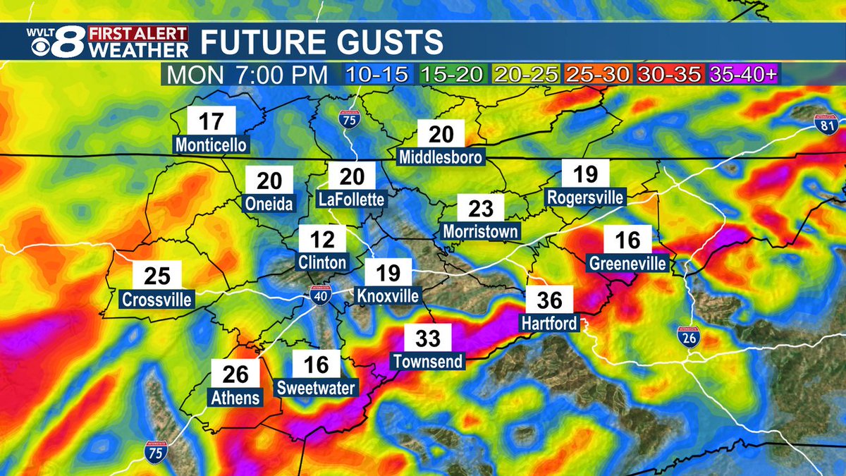
We're staying dry for Monday, but winds will pick up through the afternoon and evening. Expect gust close to 30 mph at times in the valley with higher gust in the higher elevations. We're tracking when rain returns tonight on WVLT News at 11. #wvltfirstalert #tnwx #wvltwx
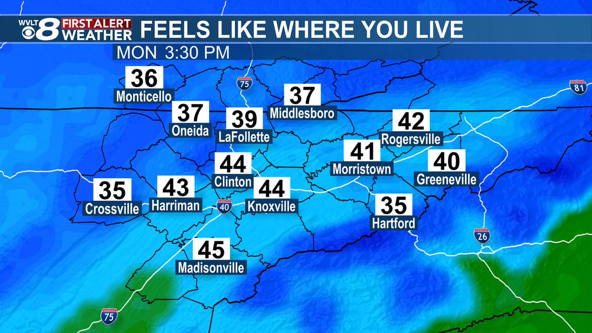
Get ready for big changes! Colder temperatures settle in for our Monday and we'll feel even colder with breezy conditions. Tune into WVLT News tonight at 11 p.m. as we break down our week ahead. #wvltfirstalert #tnwx #wvltwx
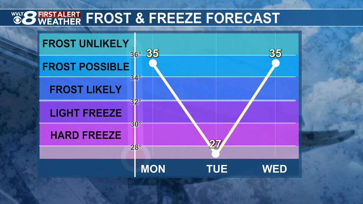
We're not done with the colder temperatures just yet! While Sunday will be another mild day, a chance for a frost and freeze arrives to start our week. We'll let you know how long the cold will last on WVLT News tonight at 11 p.m. #wvltfirstalert #tnwx #wvltwx
Good morning! It's a noisy start to the day as a cold front brings us rain and storms this morning. We have a short First Alert Weather Day for the chance for an isolated stronger storm and a messy morning commute. #FirstAlert #tnwx #wvltwx

Good morning! ☀️☀️☀️ #FirstAlert #tnwx #wvltwx

Good morning! Get out and enjoy today because rain and storms return Friday morning. Join me on WVLT News This Morning for the updated timing on tomorrow's cold front. #FirstAlert #tnwx #wvltwx

Good morning! Are you loving these sunny and warm days? Even though my allergies are killing me I'm happy to see the sunshine! #FirstAlert #tnwx #wvltwx

Did anyone else wake up with a scratchy throat? My allergies are killing me today! Trees and mold are medium today but expect tree pollen to increase this week. #FirstAlert #tnwx #wvltwx

