NiK System @NikSystem
NiK System is a department operating in the field of Remote Sensing; the reseller of satellite Images and the distrib. of Global Mapper and ASD spectrometer nik.com.tr İstanbul, Türkiye Joined March 2018-
Tweets214
-
Followers29
-
Following29
-
Likes116
And just like that... August is over😫 Time to get back to work with new energy, more coffee☕️ and maybe this cool @CopernicusEU Sentinel calendar! Download the high res version at esa.int/Applications/O…
Are you paying attention? Temperatures over land in the Northern Hemisphere for every July since 1900...
Komşu'da yangınların son durumu. Geçmiş olsun Yunanistan. (Sentinel-3, 03-09 Ağustos)
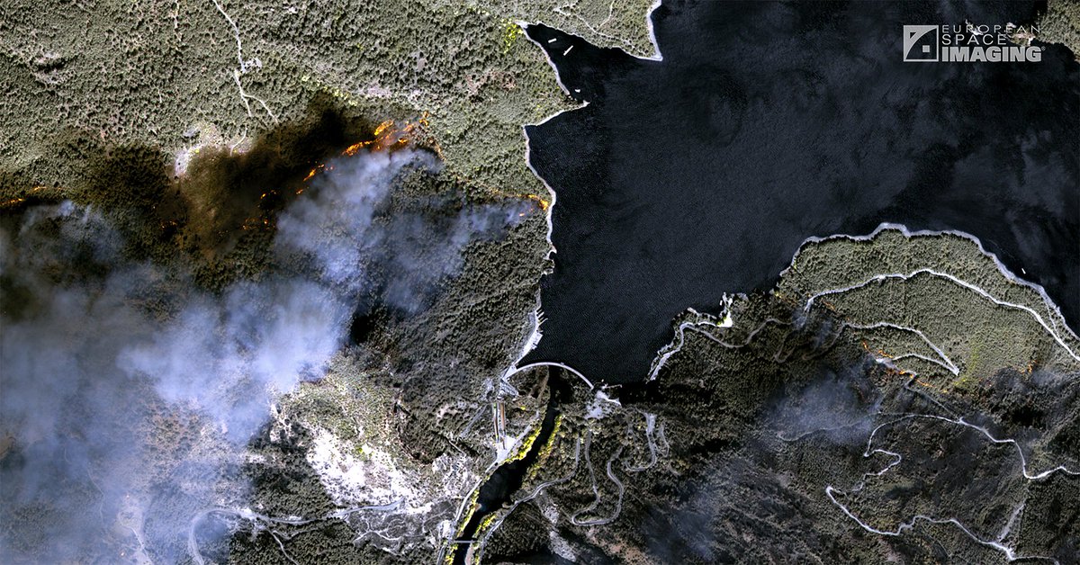
The power of 8 band multispectral imagery cannot be overstated. With the NIR2, NIR1 & Red Edge Bands, we are able to reduce the appearance of smoke and see exactly where fires are still blazing in this image from the current #GreeceFires #remotesensing #mapping #satellite
The devastating scale of the #wildfires in Greece🇬🇷 and Turkey🇹🇷 is clearly reflected in #CopernicusAtmosphere data with continuing high surface PM2.5 #airpollution in the forecast from 6 August atmosphere.copernicus.eu/charts/cams/pa… following several days of high intensity & emissions
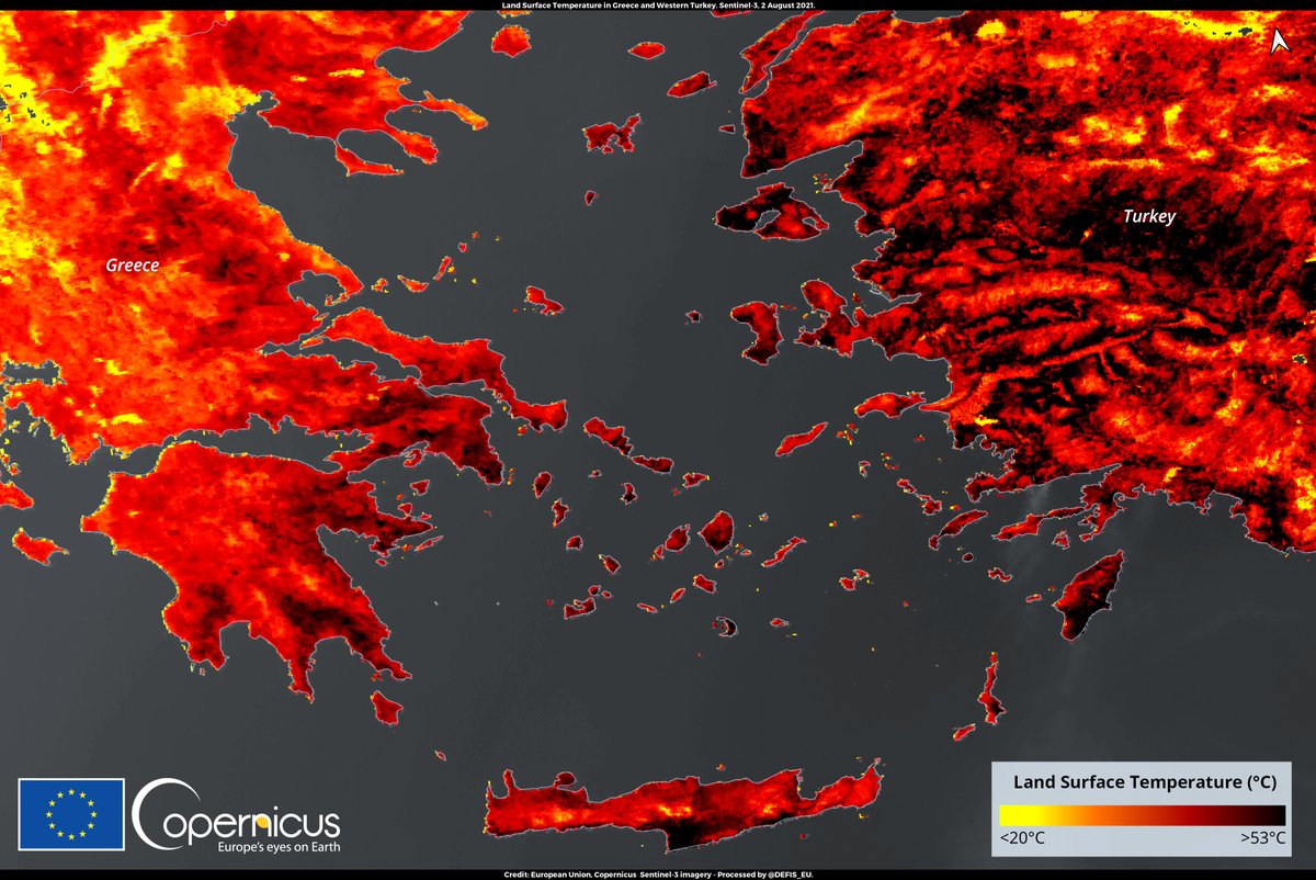
#ImageOfTheDay The Eastern Mediterranean is going through an intense #heatwave Greece is facing the most extreme temperatures 🌡️since 1987 and Turkey is affected by severe wildfires 🔥 The Land Surface Temperature #LST measured by @Copernicus #Sentinel3 🇪🇺🛰️shows peaks at 53°C
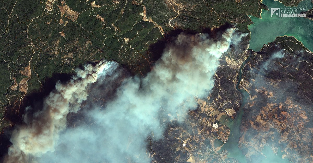
#visualstory: @EUSPACEIMAGING @maxar #Satellite imagery show severe destruction caused by a massive #wildfire in Manavgat District of Antalya Province, southern #Turkey. geospatialworld.net/article/satell… #Turkeyisburning #ClimateEmergency #TurkeyIsOnFire #disaster #wildfires #ClimateCrisis
Sentinel 3 uydu görüntüsünden yangının son durumu (29.07.2021) Geçmiş olsun Manavgat. #memleketyanıyor #Sentinel3
#ImageOfTheDay Several #wildfires are affecting the Eastern Mediterranean The most important are ongoing in the #Antalya and Mersin Provinces, in southern #Turkey ⬇️ Yesterday, 29 July, @CopernicusEU #Sentinel3🇪🇺🛰️ imaged the huge smoke clouds en route towards #Cyprus
Massive #wildfires 🔥 are affecting southern #Turkey 🇹🇷 Their location and extent can be visualised in our #EFFIS Current Situation Viewer The burn scar area estimates use #Sentinel2 #OpenData, when available, to refine the information from coarse resolution satellite sensors
#Satellite #imagery collected by @EUSPACEIMAGING yesterday with GeoEye-1 at 50 cm over #Gaza showing damage opposite @UNRWA HQ, #airstrike at Winpal Co., the Ghazi Al-Shawwa Building and Al Wehda St
.@NOAA's Climate Prediction Center's annual report anticipates an above-average number of storms will hit this Atlantic hurricane season. Daily satellite imagery can provide timely insights to emergency responders following these storms. Learn how: planet.com/pulse/the-atla…
Join us on January 27th for a day-long, virtual conference for geospatial professionals and GIS enthusiasts worldwide who share a common interest in Blue Marble's geospatial technology. youtu.be/WFahfuOcOH0 #BlueMarbleGeo #GlobalMapper #GIS #Lidar #GeoTalks
The judgment of Paris, a wine competition organized in Paris in 1976, carried out blind tastings by French judges, and two wines rated best in each category. Chardonnay from Chateau Montelena and Cabernet Sauvignon from Stag's Leap Wine Cellars won the best red wine.
Today, we would like to introduce two wineries in Italy. The first one, Gaja is an Italian wine producer from the Piemonte region in Italy. The second winery is Franz Hass located in Montagna, Italy known to produce wine with Vermentino. It is used for a diversity of white wines.
15 cm HD satellite imagery is here! Providing a new level of detail for customers and enabling accurate identification of smaller features on the ground to make more informed decisions. Contact us to learn more!
This #SV-1 imaged building complex is Jiangsu Centre for Performing Arts, which is the largest single theatre in China and largest theatre complex in Asia. Guess, what does it look like?

Soretey @SoreteyI2dRc8
30 Followers 3K Following
Alien Arts @Alien_Art5
300 Followers 3K Following 125 122 040 116 157 164 040 101 154 157 156 145 056 040 114 157 166 145 040 061 040 141 156 144 040 141 154 154 040 157 164 150 145 162 163
UDENE @UDENE_Project
29 Followers 99 Following Providing urban planners and visionaries with an innovative environment for research and natural experiments. Apply to our Open Calls!📢
Kayrros @Kayrros
5K Followers 716 Following The world leader in energy and environmental intelligence. We use satellite data and AI to help organisations make better decisions
Büşra Çelikbaş @bsrcelkbs
14 Followers 176 Following Interested in GIS applications in Natural Hazards, Human Vulnerability and Remote Sensing. MSc Student in Geological Engineering @METU_ODTU.
Victor Lavrov @Vikviklav
88 Followers 260 Following
Ramazan Küpcü @rkupcu
23 Followers 295 Following
Fulya Başak Sarıyı... @BasakSrylmz
38 Followers 126 Following
Besim.akçin @AkcinBesim
0 Followers 15 Following
Blue Marble Geographi... @BlueMarbleGeo
2K Followers 670 Following Global Mapper and Geographic Calculator | Cutting-edge software products for GIS and geospatial professionals.
Mónica Díez 🌾 @mdiegar
63 Followers 566 Following Product manager. Space, GIS, Earth Observation. Age quod agis.
ZMS @Zalizan_Salleh
53 Followers 2K Following
BusinessApplications ... @ESAbusinessapps
6K Followers 4K Following We've moved! 🚀 Find us at @Space4Europe to access funding & support for your #space enabled business. The world is ready for your idea! 🌎
febmarch @febmarch1
0 Followers 146 Following
최하나 @SIIS_HanaChoi
38 Followers 127 Following SI Imaging Services Graphic designer #SatelliteImagery #BTS😍
Kaan Kalkan @kaankalkan
1K Followers 1K Following uzaydan dünya izleyicisi maps & remote sensing earth observation researcher @tubitakuzay bsc-msc-pdh @itu1773 geomatics
Ruh İkizi @Aksi_Ruhlar
5 Followers 99 Following Bazı ruhlar, başka alemlerde (boyutlarda) birbiri ile aynı hareket ederler. Dünyevi bedenlerde dahi bu ruhlar birbirini bulduysa bunlar Ruh İkizleri’dir
*MiCHELLE*RUSSiA*💋... @SWEETROCKSTAR
443 Followers 4K Following 🚂✝️🎄🐯🐱💖🌹🌠💋❤️🚀🛰️🧸🇷🇺💋🗺️❤️💋🚀🍓♥🚀💋🇩🇪🎄✨💫🌟🚂🚜🚜🚜🌅🌹🎑💒 🇺🇸✝️🎄🎄🎄🎄🗺️✝️CLASSiCALMUSiC ♫✞♪★ 🎄🇷🇺🚀🗺️💖🌹💖★♪✞♫♥🚀🌹💖❤️💋🌅 ❤️ STARSMUSiC!🎄*L*O*V*E*❤️🇷🇺☦️❤️💋🚀💋🎄🍀🍀🍀🍀🍀🍀🍀🌈🌠
mehmet bugu @mehmet_bugu
41 Followers 494 Following
Prof. Dr. Kaan Sevki ... @ProfKaanSKavak
127 Followers 872 Following Sivas Cumhuriyet University, Turkey. Geologist and Remote Sensing Scientist
EXCELSIOR H2020 @excelsior2020eu
2K Followers 5K Following ‘EXCELSIOR’ Teaming project aims to upgrade the existing ERATOSTHENES Research Centre (ERC) to a Centre of Excellence in Space & Earth Observation in Cyprus.
Fabrizio Pirondini @FabPirondini
439 Followers 672 Following Powering the Next Generation of Earth Information
Dr. Mustafa Yalçın @mustafayalcin86
385 Followers 424 Following Geomatic engineer graduated in Istanbul Yildiz Technical University. Research Assistant at AKU University. GIS, Remote Sensing, Multi Criteria Decision Analysis
Deimos Imaging @deimosimaging
4K Followers 429 Following Deimos Imaging, an UrtheCast Company is a geo-information company providing exclusive access to Earth Observation imagery through a unique virtual constellation
Global Mapper | GIS S... @global_mapper
2K Followers 563 Following The all-in-one GIS application from @BlueMarbleGeo with a comprehensive array of data processing and analysis tools. Learn more at https://t.co/ZkNbwTQbCB
Malvern Panalytical @newsfrom_MP
4K Followers 2K Following We are a global leader in the analytics of material and life sciences. Malvern Panalytical. We’re BIG on small™
SpaceWill Info. Co., ... @spacewillinfo
836 Followers 220 Following Commercial imagery provider and marketing operator of SuperView constellation and authorized imageryprovider of Chinese imaging satellites (GF, ZY and HJ).
Harita Genel Müdürl... @harita_turkiye
8K Followers 2 Following Harita Genel Müdürlüğü Resmî X Hesabı Official X Account of Directorate General for Mapping
Kaan Kalkan @kaankalkan
1K Followers 1K Following uzaydan dünya izleyicisi maps & remote sensing earth observation researcher @tubitakuzay bsc-msc-pdh @itu1773 geomatics
Malvern Panalytical @newsfrom_MP
4K Followers 2K Following We are a global leader in the analytics of material and life sciences. Malvern Panalytical. We’re BIG on small™
Fabrizio Pirondini @FabPirondini
439 Followers 672 Following Powering the Next Generation of Earth Information
SI Imaging Services @SI_Imaging
232 Followers 133 Following SI Imaging Services (SIIS) is a leading satellite image provider for Remote Sensing and Earth Observation. SIIS is a sales representative of KOMPSAT image.
Airbus @Airbus
904K Followers 1K Following We hope you have a pleasant journey with us, as we share the latest news and views on our family of aircraft, sustainable aviation and much more. ✈️
SpaceWill Info. Co., ... @spacewillinfo
836 Followers 220 Following Commercial imagery provider and marketing operator of SuperView constellation and authorized imageryprovider of Chinese imaging satellites (GF, ZY and HJ).
Global Mapper | GIS S... @global_mapper
2K Followers 563 Following The all-in-one GIS application from @BlueMarbleGeo with a comprehensive array of data processing and analysis tools. Learn more at https://t.co/ZkNbwTQbCB
Blue Marble Geographi... @BlueMarbleGeo
2K Followers 670 Following Global Mapper and Geographic Calculator | Cutting-edge software products for GIS and geospatial professionals.
Deimos Imaging @deimosimaging
4K Followers 429 Following Deimos Imaging, an UrtheCast Company is a geo-information company providing exclusive access to Earth Observation imagery through a unique virtual constellation
ESA Space Solutions @Space4Europe
10K Followers 2K Following The go-to place for great business ideas involving space in all areas of life. We are ready for your idea! Find funding & support at https://t.co/g3cAHUzUNh
The DMC Constellation @DMCiiTweet
793 Followers 1K Following News and satellite images from the DMC Constellation, providing global daily satellite imagery and environmental monitoring of our ever changing planet.
EO OPEN SCIENCE @EO_OPEN_SCIENCE
15K Followers 826 Following European Space Agency account for the #EarthObservation (EO) #OpenScience user community. Exploring challenges & opportunities created by revolutions in #EO.
Geospatial World @geospatialworld
33K Followers 3K Following Your trusted knowledge source for all things geospatial. We delve into tech convergence and pivot to Industry 4.0 via Digital Transformation and Sustainability
Copernicus EMS @CopernicusEMS
71K Followers 2K Following Copernicus Emergency Management Service provides mapping products based on satellite imagery as well as #ForestFires #Flood and #Drought early warning products.
PlanetObserver @PlanetObserver_
585 Followers 175 Following Supplier of value-added #geospatial data, high quality PlanetSAT #satelliteimagery basemap, PlanetDEM global #elevation data and a full range of VHR data.
GAF AG @GAF_Munich
1K Followers 747 Following We are a one-stop shop for geo-information. Impressum: https://t.co/YrcnKFHdUn
EI Journal @EIJournal
715 Followers 687 Following Earth Imaging Journal is a bimonthly magazine covering a range of earth observation and geospatial technologies and applications.
NASA @NASA
88.0M Followers 158 Following Official NASA account. Exploring the universe, advancing science, and inspiring the next generation of explorers. Verification: https://t.co/8nok3NP4PW
SpaceX @SpaceX
40.1M Followers 120 Following SpaceX designs, manufactures and launches the world’s most advanced rockets and spacecraft
Planet @planet
255K Followers 4K Following We see things from a different angle. 🛰️🕊️ Public Benefit Corporation on NYSE $PL
Group on Earth Observ... @GEOSEC2025
19K Followers 4K Following 🛰️ Translating Earth Intelligence with global collaboration. ℹ️ https://t.co/I3zKOfaBls #EarthIntelligenceForAll #MapEcosystems
EOPages @EOPages
1K Followers 565 Following EOpages is a #marketplace between the Earth Observation Service Industry & Users powered by @earsc #remotesensing #earthobservation
EARSC @earsc
7K Followers 1K Following European Association of Remote Sensing Companies. Our mission is to foster the growth of the #Earthobservation services sector in Europe.
ISPRS IJGI @ISPRS_IJGI
2K Followers 1K Following IJGI (ISSN 2220-9964; IF 2.8 is an Open Access journal of the ISPRS and is published monthly online by MDPI. Editor-in-Chief: Prof. Dr. Wolfgang Kainz
European Space Agency @esa
1.8M Followers 1K Following #50YearsOfESA: we're the European Space Agency, keeping you posted on European space activities. Please see our Privacy Notice: https://t.co/UkkEqaJOwd
EUSI @EUSPACEIMAGING
6K Followers 662 Following 🛰 Satellite imagery for Europe and North Africa 📸 Native resolution up to 30 cm ⏳️ Near real-time delivery up to 15 min after collection

