3dtarget @3dtarget
3D TARGET was founded to provide assistance, products, rental, and training courses about NDT (Non Destructive Test) to every company, professional and PA. 3dtarget.it Italia Joined October 2011-
Tweets1K
-
Followers267
-
Following274
-
Likes163
Sblocca ispezioni di nuovo livello con #DJIDock 2! Potente, compatto e facile da trasportare, con valutazione pre-volo autonoma. #DJIDock2 rivoluziona il dispiegamento di droni. ✈️ Scopri di più: 3dtarget.it/eu/it/droni/pr… #droni #tecnologia #business #innovazione #sicurezza
⚙️ Pronto a rivoluzionare il tuo modo di lavorare con la scansione laser autonoma? BLK ARC si integra con robot come Boston Dynamics #Spot per un flusso di lavoro di cattura della realtà rapido, sicuro e autonomo. Scopri di più: 3dtarget.it/eu/it/laser-sc…
Buona Pasqua a tutti! In occasione della Santa Pasqua, vi auguriamo a voi e alle vostre famiglie un periodo di serenità e gioia. Cogliamo l'occasione per informarvi che i nostri uffici resteranno chiusi lunedì 1 aprile. Torneremo operativi martedì 2 aprile.
Droni per ispezioni pannelli solari: rivoluziona il tuo lavoro! I droni DJI offrono: 🔺Maggiore efficienza e accuratezza 🔺Riduzione dei costi fino al 70% 🔺Migliore sicurezza Scegli di innovare: 3dtarget.it/eu/it/droni/pr… #droni #ispezionisolari #energiapulita #futurosostenibile
Rilievi rapidi e precisi in villaggi svizzeri con @Wingtra One! Efficienza: da 2 settimane a 3 giorni per mappare 500 ettari. ⏱️ Precisione: 3 cm di risoluzione, ideale per la misurazione catastale. Scopri di più: 3dtarget.it/eu/it/droni/pr… #VTOL #dronedata #digitalrevolution
Termografia: Mai più sorprese costose! Scopri le perdite nascoste con @flir -Individua perdite in modo rapido e preciso. -Prendi decisioni più informate. -Lavora in modo più intelligente. Non aspettare il disastro! Acquista una termocamera FLIR oggi! ℹ️ 3dtarget.it/eu/it/termocam…

Trasforma i tuoi progetti con @LeicaGeosystems ! Crea un gemello digitale del mondo reale e migliora il tuo processo decisionale. Scopri come: Ottenere dati rapidi e precisi Eliminare incertezze e ridurre rischi Lavorare in modo più efficiente ℹ️ 3dtarget.it/eu/it/laser-sc…

🚁 Il governo norvegese vola alto con i droni VTOL! 🌐 Risparmio di tempo: da 5 giorni a 1 ora per 5 km! ⏳ Risparmio sui costi, ampia copertura ed elevata precisione. ℹ️ 3dtarget.it/eu/it/droni/pr…
💸 £7 miliardi spreco energetico in UK ogni inverno! FLIR rivela £363 per casa. 49% preoccupati, solo 5% richiede valutazione tecniche. FLIR: termocamere precise, ottimizza il tuo business! #SprecoEnergetico #FLIR #EfficienzaEnergetica 🌐 3dtarget.it/eu/it/termocam…

🌟 Rivoluziona il tuo approccio alle sfide termiche con la FLIR Cx-Series! Scopri la potenza dell'essenziale con la FLIR C3-X e l'eccellenza della FLIR C5. 🔍 Visita il nostro sito per scoprire tutti i dettagli: 🌐 3dtarget.it/eu/it/termocam… #Termocamere #TecnologiaTermica

Droni e Neve: Sicurezza sulle piste! Le stazioni sciistiche abbracciano la tecnologia DJI #Matrice350 e #ZenmuseH20N, le infrastrutture sono così controllate con efficienza, garantendo la sicurezza degli sciatori. 🌐 3dtarget.it/eu/it/droni/pr…

🌿✈️ Inizia il 2024 esplorando nuove frontiere con droni MicaSense Altum! Scopri come la Rogers Family Coffee sta rivoluzionando la gestione agricola con i sensori della serie #MicaSense #Altum. 🌐 3dtarget.it/eu/it/droni/pr… #MicaSenseAltum #InnovazioneAgricola

🎄Buone feste da 3D Target! 🎅 Grazie per il vostro supporto e fiducia in questo anno ricco di traguardi. Vi auguriamo di trascorrere un sereno Natale e un felice anno nuovo! Rimanete sintonizzati, nel 2024 raggiungeremo nuovi traguardi insieme! 3dtarget.it/eu/it/eventi.h…
🌐Rivoluziona l'ispezione delle turbine eoliche con #Cubert #Hyperspectral La camera iperspettrale offre una valutazione accurata dei danni, contribuendo ad un futuro più sostenibile nel settore delle energie rinnovabili. ℹ️ 3dtarget.it/eu/it/droni/pr… #Sostenibilità #Innovazione

🆕 Scopri il futuro della scansione laser autonomo con Leica BLK ARC! #LeicaBLKARC #ScansioneLaser Acquisisci dati in modo efficiente e sicuro con questa tecnologia all'avanguardia. 🌐 3dtarget.it/eu/it/laser-sc…

🚀 Elevate your lidar experience with Scanfly's SmartProcessing software! 🌐 Easy-to-use, precise, and efficient, #Scanfly streamlines your workflow, revolutionizing lidar scanning. 🖱️ Learn more: scanfly.it/products/smart… #LidarTechnology #SmartProcessing #RevolutionizeScanning
🌐📸 Multispettrale e pansharpening: la magia dell'elaborazione dati. Le piante parlano attraverso la luce e le telecamere multispettrali ascoltano! ℹ️ 3dtarget.it/eu/it/droni/pr… #agritech #MicaSense #multispectral #AltumPT #agriculture #agritechnology #dronesensor

Il nuovo @LeicaGeosystems #BLK2GOPULSE rivoluziona la cattura della realtà, offrendo un'esperienza di scansione immersiva in tempo reale. Contattaci per ottenere ulteriori informazioni su come ottimizzare il tuo business con questi strumenti innovativi. 3dtarget.it/eu/it/laser-sc…

❄️🚁 Consigli Manutenzione Invernale per Droni: Carica e preriscalda le batterie, rimuovi neve, vola con responsabilità. Dopo il volo, pulisci, conserva al caldo, ed effettua regolare manutenzione per operazioni invernali affidabili. #ManutenzioneDroni #VoloInvernale #Sicurezza

🚁✨ Roma Drone Conference 2023 presso l’UNIVERSITÀ EUROPEA DI ROMA! Giornata intensa di conoscenza e dibattiti sul futuro dei #droni e dell'Air Mobility in Italia. Vuoi approfondire? 🤝🌐3dtarget.it/eu/it #InnovazioneTecnologica


edwardyao @edwardyao
71 Followers 282 Following
Ross McDowall @DoppioRoss
68 Followers 342 Following
alessandro chiodin @AChiodin
63 Followers 729 Following

Lorenzo De Gouveia @lorenzosaul
167 Followers 943 Following 30' Aprendo a diario y me equivoco todos los días. Católico Cristiano. Esposo de Maria Andueza. Hijo de Marisol y Saul. Geodesta. Futbolero Apasionado.
wenjun xu @wenjunx84919637
61 Followers 178 Following
stephen @stephen_zhuye
8 Followers 91 Following

AgEagle Aerial System.. @AgEagleUAVS
9K Followers 861 Following Drones, sensors and software for automated aerial intelligence. Combining solutions from senseFly, MicaSense and Measure.
Simone @SimoneBLK1228
1 Followers 43 Following
FFFD00 ATELIER @nuvoladipunti
0 Followers 13 Following Lo studio FFFD00ATELIER da anni opera nel settore del rilievo architettonico e modellazione tridimensionale. Catturiamo la realtà attraverso le nuove tecnologie
JRuiz @JRuiz70036986
1 Followers 18 Following
Leica BLK Original @LeicaBLK
1K Followers 353 Following A powerful and sleek series of laser scanning and reality capture sensors. Elegantly simple. Always accurate. Digitize reality with confidence.
GeoSmartCampus @geosmartcampus
517 Followers 986 Following Digital Geography Accelerator for Startups & SMEs! Growing Geo-Creativity Innovation through the Digital Trasformation! [email protected]

Land of Nineveh AP @LandofNinevehAP
1K Followers 285 Following Official account of the Land of Nineveh Archaeological Project. Iraqi Kurdistan. University of Udine, Italy.
Luca Pistoni @LucaPistoni00
3 Followers 3 Following
Falcon Trails Videos @FalconTrailsVid
46 Followers 661 Following https://t.co/AUQf9mCgii THE #video repository for #Utah #trails! #360VR #mountainbiking #hiking #youtube
Lorenzo Conca @Conca3DT
4 Followers 31 Following
Narendra Patel @Narendr86694206
6 Followers 99 Following My name is Narendra Patel and Graduated in https://t.co/In7vBKd4qh Civil Engineer. I am working in the Aeris infrastructures india pvt ltd
SCCS @SCCSSURVEY
2K Followers 198 Following The UK's leading provider of surveying equipment and solutions for positioning and measurement. Part of @HexagonAB. #Surveying #Monitoring #DigitalConstruction
Paolo Pellegrinelli @PaPe1488
2 Followers 15 Following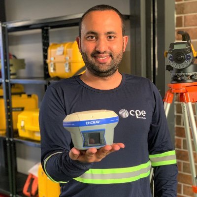
Joêmio Corrêa Barbo.. @LicenciadosB
9 Followers 145 Following 📏 Consultor Comercial Licenciadas - CPE Tecnologia 📏 Locação e Venda de equipamentos 📏 Contato: 3199060-0248 📚 Conteúdo: Geotecnologia https://t.co/UsQm4ALIRl
Jasmine Liu @FatiAmorCeline
34 Followers 1K Following

Anthony Randall-Claus.. @MWGeospatial
0 Followers 128 Following

Polyga @Polyga3D
184 Followers 220 Following We're on a mission to build simple, user-friendly tools that use 3D scan data to its fullest potential for manufacturing applications.Gerd Schwaderer @gerdschwaderer
108 Followers 101 Following Make the world a better place. Anything about Voxels and Polygons…
Dasù @dasu_vadovolove
12 Followers 43 Following 🚁🚁🚁 Servizi con Droni 🚁🚁🚁 💦 Lavaggio Facciate 📐 Rilievi Architettonici e Topografici 🔍 Ispezioni 🌡 Analisi Termografiche 🎥 Riprese Aeree
Innoviz Technologies @InnovizLiDAR
4K Followers 1K Following Autonomous vehicle technology that is on a mission to change the world. #LiDAR #AutonomousVehicles #ADAS #perception #sensing
Kunal Dharod @Kunaldharod18
13 Followers 97 Following
ME001940a @ME001940a
0 Followers 851 Following
ND Aerial Service @NDAerialService
9 Followers 36 Following ND Aerial Service lavora nel campo della geomatica offrendo un ampio ventaglio di servizi per l’acquisizione di dati morfologica, tramite UAS
#NEWPALMYRA @NewPalmyraOrg
3K Followers 2K Following To the preservation and futurism of architecture destroyed in conflicts. Email [email protected]
Christian M. Baldin @baldinchristian
282 Followers 2K Following Environmental Engineer - Precision Farming - #Laboratory of #Geomatics - #Unipv #dicar #ArcGIS #Python #DataScience #RemoteSensing
Silvia Lazzarini @LazzariniSilvia
8 Followers 9 Following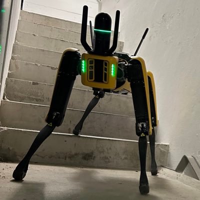
Simone Oppici @simoneoppici
303 Followers 171 Following Business Manager Reality Capture. Appassionato di tecnologia.

Ugo @Brugeom
1 Followers 37 Following
Kerry Hudson @Kezzalou73
28 Followers 299 Following
Shane Armstrong @SGAVC2021
913 Followers 5K Following
AgrHySMo Lab. @agrhysmo
243 Followers 976 Following This lab harmonises the three pillars of knowledge with the scope of transmitting/transferring them to the Irrigation Industry and Higher Education sectors
SCANFLY @scanfly3dt
45 Followers 65 Following The payload lidar not only for UAS - Follow us and discover Scanfly World
R @AfterMineR
149 Followers 324 Following #Mining & #Geotechnical. Associated with @nitrourkela and @icoldcigb
Eduardo Freitas Olive.. @eduol
444 Followers 2K Following Entusiasta Geo/Drones (Imagem de capa: Carina Nebula NIRCam Image - Telescópio Espacial James Webb)
HDMS & Standard GIS, .. @LittleRockLiDAR
98 Followers 357 Following HDMS & Standard GIS is a team of professionals delivering Architecture, LiDAR & 3D Mapping solutions that allow our clients to take back control of their time.
AgEagle Aerial System.. @AgEagleUAVS
9K Followers 861 Following Drones, sensors and software for automated aerial intelligence. Combining solutions from senseFly, MicaSense and Measure.
Land of Nineveh AP @LandofNinevehAP
1K Followers 285 Following Official account of the Land of Nineveh Archaeological Project. Iraqi Kurdistan. University of Udine, Italy.
Luca Pistoni @LucaPistoni00
3 Followers 3 Following
Paolo Pellegrinelli @PaPe1488
2 Followers 15 Following
Leica Geosystems US @LeicaGeoUS
4K Followers 881 Following With accurate instruments, sophisticated software, and trusted services, Leica Geosystems delivers value every day to those shaping the future of our world.
☁ 𝗖𝗹𝗼𝘂�.. @CloudCompareGPL
3K Followers 75 Following Open source 3D point cloud processing and editing software
RNDT @rndt_it
1K Followers 555 Following Account ufficiale del Repertorio Nazionale dei Dati Territoriali | 🇮🇹 National Catalogue for Spatial Data | Agenzia per l'Italia Digitale @AgidGov
Esri @Esri
193K Followers 70K Following Esri builds #ArcGIS, the leading location intelligence and spatial analytics software for mapping, 3D GIS, imagery, and geospatial app development.
Yangda Security @yangdasecurity
267 Followers 619 Following One-Stop Shop For Drone Zoom Camera | Multirotor & VTOL Fixed-wing | Video Transmitter | Always HIGH Quality Products!
ND Aerial Service @NDAerialService
9 Followers 36 Following ND Aerial Service lavora nel campo della geomatica offrendo un ampio ventaglio di servizi per l’acquisizione di dati morfologica, tramite UAS
Topcon Positioning It.. @topconitalia
440 Followers 194 Following Filiale italiana Topcon Positioning Group
Mauro Contrafatto @maucont77
88 Followers 1K Following
#NEWPALMYRA @NewPalmyraOrg
3K Followers 2K Following To the preservation and futurism of architecture destroyed in conflicts. Email [email protected]
LukasMaps 🌍🗺�.. @lukas_maps
72 Followers 444 Following Page created to share maps, aerial photos made by me on different topics and geographic areas. If you like what you see put a like, comment and share it😉 😉 😉
... @guvennozz
904 Followers 203 Following
SCANFLY @scanfly3dt
45 Followers 65 Following The payload lidar not only for UAS - Follow us and discover Scanfly World
MetrologyWorks @MetrologyWorks
303 Followers 239 Following Hi - Performance 3D Measurement. Contact us for all your portable CMM needs! 816-650-2266
Metrology News @Metrology_News
1K Followers 90 Following
Eduardo Freitas Olive.. @eduol
444 Followers 2K Following Entusiasta Geo/Drones (Imagem de capa: Carina Nebula NIRCam Image - Telescópio Espacial James Webb)

StockMars @StockMars
34K Followers 1K Following Stock-Options Trades are my opinion only n not investment advice. I’m not professional trader. $IONQ $RGTI $QBTS $MARA $COIN $JOBY $ACHR $EH $SOFI


Telespazio @telespazio
7K Followers 1K Following Official account of Telespazio, joint venture between @Leonardo_live (67%) and @thalesgroup (33%) and a leading player in space-based services.
Master GIS Droni @MasterGIS_Droni
677 Followers 439 Following Master universitario(II livello)in #GIScience e Sistemi a Pilotaggio remoto #SAPR per la gestione del territorio e delle risorse naturali-7 indirizzi @UniPadova
TerreLogiche @TerreLogiche
553 Followers 436 Following Formazione, servizi GIS e webGIS su tecnologie Open Source, monitoraggio ambientale, Geostatistica, Open Data aggregation, soluzioni software gestionali.
TS Service @service_ts
27 Followers 45 Following
Dielmo3D @DIELMO3D
531 Followers 520 Following https://t.co/EpqRNobeMR - Experts in advanced custom #LiDAR #Mapping services. You can count on our reliability, experience and high capacity for your LiDAR projects.
Leonardo @Leonardo_IT
41K Followers 1K Following Benvenuti sull’account 🇮🇹 di @Leonardo_live! Siamo un'azienda di Global Security, che realizza tecnologie per un futuro più sicuro.
Juha Heikkinen @joheikki
134 Followers 743 Following
GeospatialNet @GeospatialNet
1K Followers 2K Following Geospatial videos, articles, Maps and news relating to #Geomatics, #GIS, #RemoteSensing, #Surveying, #GPS and #Geospatial Technology.🇪🇺 EGNOS Portal @EGNOSPortal
4K Followers 834 Following The European Geostationary Navigation Overlay Service #EGNOS is EU regional #SBAS used to improve the performance of GNSSs🧭 #EUSpace #EUSPA See also @EU4Space
Global Mapper | GIS S.. @global_mapper
2K Followers 599 Following Global Mapper®is an all-in-one GIS application from @BlueMarbleGeo with a comprehensive array of data processing and analysis tools. Learn more https://t.co/ZkDr65K04Q
senseFly, now AgEagle @sensefly
17K Followers 383 Following We are now @AgEagleUAVS, provider of professional solutions in drones, sensors and software. Follow us there.
🇪🇺 EUSPA - EU A.. @EU4Space
19K Followers 925 Following EUSPA provides safe & performant #EUSpace Services, linking @CopernicusEU, EGNSS & SATCOM to EU citizens, and operates the @EU_SST Front Desk.
AutonomouStuff @AutonomouStuff
3K Followers 512 Following Enabling the future of autonomy as part of @HexagonAP
MicaSense, now AgEagl.. @MicaSense
4K Followers 1K Following We are now @AgEagleUAVS, provider of professional solutions in sensors, drones and software. Follow us there.

Tree Company CO @TOPCON_Greece
293 Followers 45 Following Στόχος της "Tree Company Corporation A.E.B.E" είναι η παροχή και υποστήριξη ολοκληρωμένων λύσεων υψηλής τεχνολογίας για τον Έλληνα επαγγελματία.
ESA Partnership Proje.. @Partner_InOrbit
5K Followers 91 Following Your trusted partner in orbit, that powered your sustainable development of end to end systems up to in-orbit validation, for over 2 decades
paolo girardi @paologirardi3
13 Followers 35 Following
Leica Geosystems UAS @LeicaGeoUAS
428 Followers 122 Following Leica Geosystems Inc. UAS is now part of Reality Capture. We are driving the 4th Industrial Revolution.
The Geospatial @TheGeospatial
799 Followers 2K Following Fastest growing Geospatial portal. Download our APP from Play store. All about #gis #geospatial #lidar #maps #isro #iot #gps #gnss #BIM #location #drones
LidarSurvey.net @LidarSurvey
371 Followers 812 Following
Renzo Carlucci @rcarlucci
657 Followers 411 Following Chief editor of GEOmedia and Archeomatica, leader magazine in Italy about technologies for geomatics, geographic information and cultural heritage.
e-distribuzione @edistribuzione
6K Followers 260 Following Benvenuto sul profilo ufficiale di #edistribuzione. Seguici per essere sempre aggiornato su tutte le nostre attività! Per assistenza scrivi a @ed_help
World Heritage USA @WHUSA1965
4K Followers 406 Following World Heritage USA, supporting ICOMOS-USA and the preservation of cultural heritage globally
ICOMOS @ICOMOS
21K Followers 330 Following International Council on Monuments and Sites Conseil International des Monuments et des Sites Retweets ≠ endorsementsMeet @NationalHways newest friend, Spot, & its autonomous laser scanning companion, the Leica BLK ARC. They plan to trial this as part of their geotechnical surveys taking place later this year, to get to areas that are inaccessible or unsafe! 📽️: @NationalHways @BostonDynamics
#AandRExpo Athens starts today! See the Mobile Mapping System, Scanfly EVO custom black edition at #TreeCompany (Hall 1 D03). Multi-platform LiDAR solution 🇬🇷 scanfly.it #LiDAR #ScanflyEVO #TreeCompany

🇷🇴 Romania! 3D scanning enthusiasts, don't miss the 3DT-SCANFLY World Tour on 27/03 with our reseller SysCAD Solutions ! ℹ️ MORE INFO: forms.office.com/e/RpLbvUDwvs #3DTscanning #Romania #Innovation #SCANFLYWORLDTOUR

Great connections at #GeoConnectAsia! Thanks to everyone who visited our booth & to AECA Solutions & organizers for their support! Learn more about our geospatial solutions: scanfly.it
Level up your geospatial projects at #GeoConnectAsia! 3D TARGET SCANFLY (Booth G33) helps you: ✅ Streamline data collection & analysis ✅ Gain deeper environmental insights ✅ Make smarter decisions ➡️ scanfly.it #3DTARGETSCANFLY #Innovation

Rilievi rapidi e precisi in villaggi svizzeri con @Wingtra One! Efficienza: da 2 settimane a 3 giorni per mappare 500 ettari. ⏱️ Precisione: 3 cm di risoluzione, ideale per la misurazione catastale. Scopri di più: 3dtarget.it/eu/it/droni/pr… #VTOL #dronedata #digitalrevolution
Unlock asset management & digital twins! Join 3D TARGET SCANFLY at Geo Connect Asia 2024 (SG)! Booth G33. Register: gevme.com/Geo-Connect-As… #GeoConnectAsia #3DTARGETSCANFLY #LiDAR

🛣️ LiDAR DAY at Geo Week 2024! Visit SCANFLY booth 303 for live demos. Exciting news this Friday! #ScanflyDemo Don't miss the future unfold! 𝗥𝗲𝗱𝗲𝗳𝗶𝗻𝗲 𝗺𝗮𝗽𝗽𝗶𝗻𝗴: 𝗮𝗻𝘆𝘁𝗶𝗺𝗲, 𝗮𝗻𝘆𝘄𝗵𝗲𝗿𝗲 𝘄𝗶𝘁𝗵 𝗦𝗰𝗮𝗻𝗳𝗹𝘆 𝗘𝗩𝗢 & 𝗣𝗥𝗢! scanfly.it/geo-week-2024/

🌐 Scanfly at GEO WEEK 2024! 🚀 Join us at booth 303 for cutting-edge geospatial tech. 🗓️ 11-13 Feb, Colorado Convention Center. Scanfly Demo on 13 Feb, 2:00 pm MT, at Holiday Inn Express Denver. Experience our Scanfly ON BOARD VERSION! ℹ️ scanfly.it/geo-week-2024/

🎄 Merry Christmas from 3D Target Scanfly! 🎅 Wishing you a joyous holiday season and a prosperous new year filled with success and innovation. 🥂 SCANFLY NEWS: scanfly.it/news/latest-ne…
🚀 Elevate your lidar experience with Scanfly's SmartProcessing software! 🌐 Easy-to-use, precise, and efficient, #Scanfly streamlines your workflow, revolutionizing lidar scanning. 🖱️ Learn more: scanfly.it/products/smart… #LidarTechnology #SmartProcessing #RevolutionizeScanning
🌍 Join us at @intergeo 2023 in Berlin! Explore geospatial tech and innovation at stand #3DTarget Scanfly. 💡 Discover our innovative solutions, don't miss it! 🚀 #INTERGEO2023 #GeospatialTech

The #TrimbleUserConference, by @GEOTRONICSPraha, is taking place in the Czech Republic and SCANFLY is on display. We have received positive feedback from attendees and we continue exploring future opportunities for #SCANFLY.

🗺️ Exciting news! SunCart and the Romanian Orienteering Federation are revolutionizing orienteering maps with LiDAR technology. Precision mapping for the ultimate navigation experience! 🌲 🔍📖 Discover the full case study: scanfly.it/application/or…


New article "#OpenStreetMap as an input source for producing governmental datasets: the case of the Italian Military Geographic Institute" by @MarcoMinghini @napo and myself in the Archives of @isprs doi.org/10.5194/isprs-…


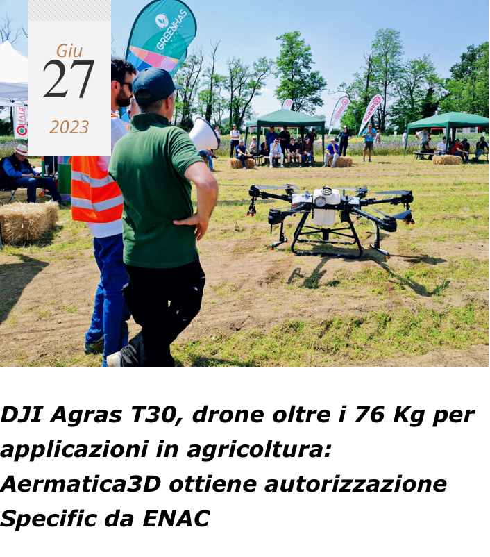
📣Aermatica3D ha ottenuto l'autorizzazione da ENAC per il DJI Agras T30. 🚁✅ Per saperne di più', contattaci a [email protected]
The #eBeeVISION drone, 3.5 lbs / 1.6 kg, compact design, deployable in 3 minutes, and operable by 1 person. RGB and thermal #UAV operates in challenging environments to provide live HD video feed for intelligence, surveillance and reconnaissance (#ISR) bit.ly/3JyyoPc

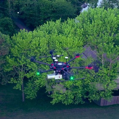
Siamo entusiasti di presentare il nuovo @DJIGlobal #Matrice 350 RTK, un drone che offre prestazioni di volo ed esperienza di controllo avanzata leader nel settore! ℹ️ Scopri ora il drone e i suoi payload: 3dtarget.it/eu/it/droni/pr…

Siamo entusiasti di annunciare il lancio della nuova camera @MicaSense, con RedEdge-P dual raddoppia il potenziale di analisi! ℹ️ Scopri la scheda tecnica completa di RedEdge-P dual: 3dtarget.it/eu/it/droni/pr…

Trends for United States
You might like