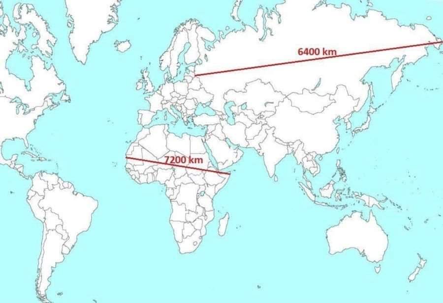
Map showing the actual distance between two points and how it looks using the mercator projection

@amazingmap For perspective, Greenland and Mexico have the same size landmass…There’s a great book called, “How to lie with Maps”.

@amazingmap We have globs now. Just zoom out on Apple/Google maps.

@amazingmap ...so Gerard Mercator was a fraude - see⬆️proof. #ThereISaidIt

@amazingmap I was aware of the distortions created by representing a 3D object on a 2D surface, but I've never seen this comparison before 😍


@amazingmap the lengths are correct guys. Look at what happen when you move Russia onto the equator! 🤯:


@amazingmap A more accurate escale of the world map


@amazingmap @TerribleMaps @shacharlotan אם קיים עוד איזשהו סיכוי שלא ראית

Introduced by Gerardus Mercator in 1569, the Mercator projection is a widely used cylindrical map ideal for navigation, as straight lines reflect constant true bearings. However, it distorts scale, making regions near the poles appear larger than they are, e.g., Greenland looks larger than South America.


@amazingmap The real size of Greenland 🇬🇱
