Search results for #StormWatch12
#STORMWATCH12: Just like yesterday, it'll be a cool day with small shower chances. The best shower coverage, once again, will be along and west of the Cascades @KDRV #orwx #cawx


#STORMWATCH12: The best chance of showers today will be in Curry, Josephine, Jackson, and a little slice of Klamath County. (along and west of the Cascade ridgeline). Otherwise, it'll be a cool day with highs 10-degrees below average! @KDRV #orwx #cawx


#STORMWATCH12: Expect around 4-8" of snow on our Cascade passes over the next couple days. Thankfully, other mountain passes in our region should generally be spared by the snow @KDRV #orwx #cawx

#STORMWATCH12: Although there are small small shower and thunderstorm chances for today, much more widespread rain/storms are in store for Thursday and Friday. This'll be a decent wetting rain, so fire start potential is limited @KDRV #orwx #cawx


A tough drive on I-5 north of Weed through Edgewood. This strong thunderstorm is producing heavy rain, a lot of lightning and is capable of 40 mph wind gusts and pea size hail. Be cautious driving through some of these storms firing up today. #StormWatch12 #CAwx

#STORMWATCH12: It'll be another very warm day, but slightly different compared to Monday. We'll have small shower/thunderstorm chances into the afternoon and evening for inland spots. The best coverage will be in Siskiyou, Klamath, and Lake counties @KDRV #orwx #cawx


#STORMWATCH12: Who's ready for cooler and wetter weather? By Thursday and Friday, we'll be about 20-degrees cooler compared to Monday! At this point, showers and thunderstorms will be likely, as well @KDRV #orwx #cawx


A storm system will impact us tomorrow. We'll see winds picking up out of the west and southwest for most of us, but showers will mainly only impact the coast. Rainfall amounts will be pretty light too. A closer look at your complete weekend forecast @ 6. #StormWatch12


#STORMWATCH12: Friday will essentially be a carbon copy of Thursday's forecast, if not a smidge warmer. Get out there and enjoy this warm and sunny end to the work week! @KDRV #orwx #cawx

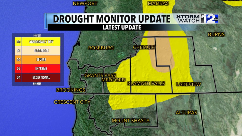
Some good news on the #DroughtMonitor update for this week. The moderate drought on the eastside shrunk after last weekend's rain and snow. On this evening's newscasts, I'll let you know if there's anymore wet weather in our extended forecast. #StormWatch12 #ORwx #CAwx

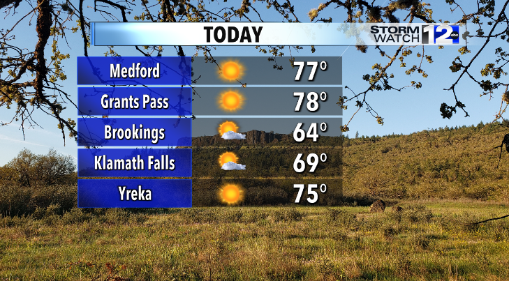
#STORMWATCH12: Highs today will be about 10-degrees above average for mid-April. In other words, expect sunny-and-75 kind of weather for Rogue Valley today! @KDRV #orwx #cawx


After another chilly start tomorrow, it'll be noticeably warmer in the afternoon with more ample sunshine. Temperatures warm even further away from the coast for Friday. #ORwx #CAwx #StormWatch12

It was a very chilly and frosty morning, but we saw a beautiful sunrise this morning down in the Shasta Valley! Check out this photo sent in from viewer Linda Richter. 😍 #CAwx #StormWatch12

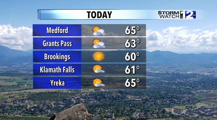
#STORMWATCH12: Expect more sunshine today with highs that'll be just a few degrees above average for mid-April. It's not totally out of the question that a few westside valley locations could hit 70-degrees! @KDRV #orwx #cawx

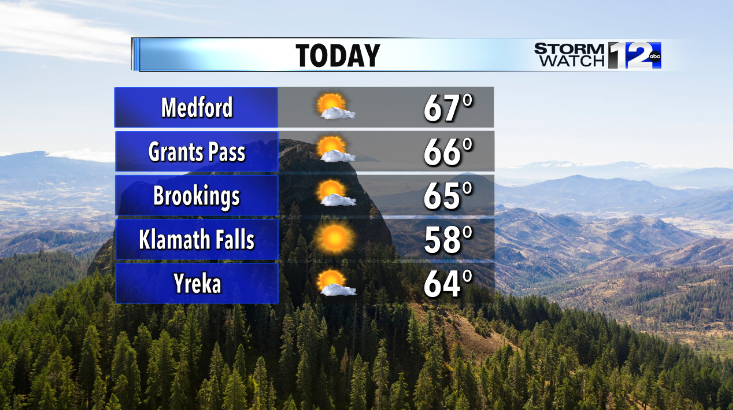
#STORMWATCH12: Dry and seasonal weather continues for Tuesday. Just like yesterday, clouds could be a bit stingy before lunchtime--especially in the Rogue Valley. However, expect plenty of sunshine by the afternoon! @KDRV #orwx #cawx

A bit milder tomorrow with sun and clouds and breezy winds for the Rogue Valley. A colder and frosty start to Wednesday before much warmer weather arrives by Thursday afternoon. #StormWatch12 #ORwx

Sun and clouds and dry weather tomorrow with fairly seasonal afternoon temperatures. However, with clearing skies into tomorrow night, we’re expecting a cold one with frost and freeze concerns for our westside valleys. Details coming up @ 5! #StormWatch12 #FreezeWatch


#STORMWATCH12: Who's ready to be back near 80-degrees? We'll warm things up with dry and sunny weather all throughout the work week! @KDRV #orwx

Thunderstorms will fire up this afternoon east of the Cascades and then work northwest through the early evening hours. In the marginal risk area, one or two storms could be strong to severe with damaging wind gusts and 1"+ diameter hail being the main concern. #StormWatch12


Only two more days left of the ski season at Mt. Ashland and Mt. Shasta! We'll end the season Sunday with some fresh powder for both of the ski areas. Mt. Shasta ski park will see several inches of new snow later through the weekend. ❄️⛷️🏂❄️ #StormWatch12


Auto @Stormwatch12
17 Followers 136 Following