Chris Holmes @opencholmes
Working towards Cloud-Native Geospatial, through involvement in @GeoParquet, @planet, @STACSpec, @cogeotiff, @cloudnativegeo & @source_coop. cholmes.medium.com San Francisco, CA Joined May 2013-
Tweets2K
-
Followers4K
-
Following153
-
Likes3K
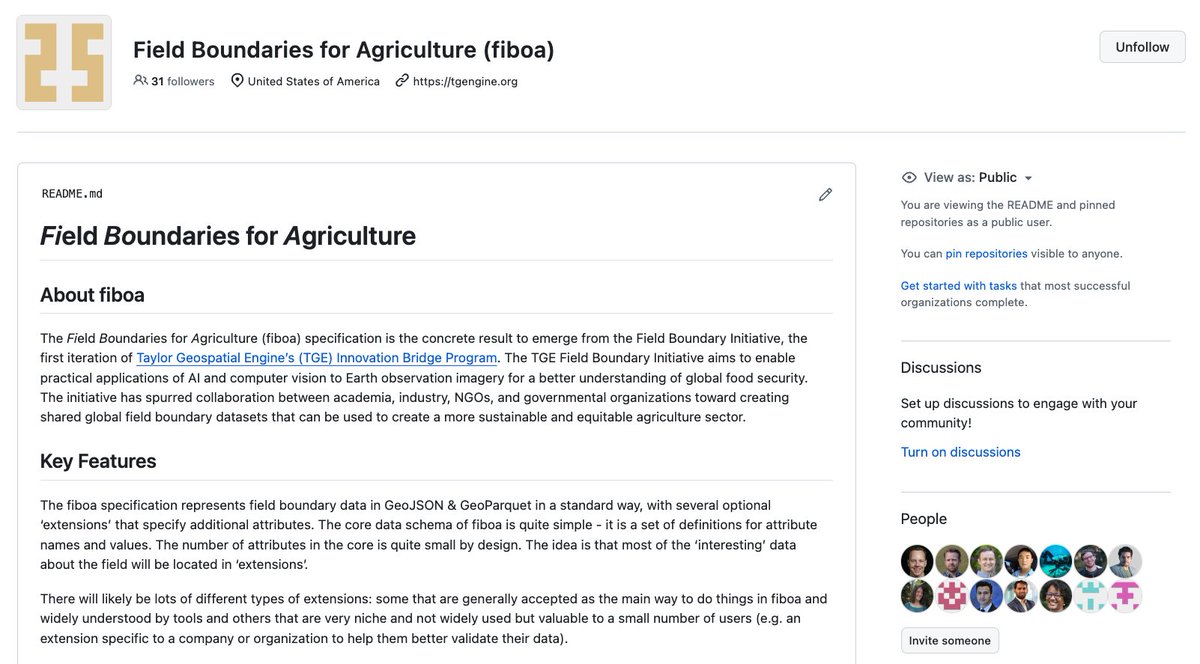
Learn about the #fiboa specification for standardized field boundary data in @GeoJSON & @GeoParquet! @opencholmes breaks down the core spect and its extensions in this blog post cloudnativegeo.org/blog/2024/04/f…

Its important to separate sci-fi from sci-fact when investing in the space industry I started Space Case 3yrs ago because there was too much fake news space stock analysis YouTubers and Reddit-ers saying “this stock is LITERALLY going to the moon” + people getting caught up in…
STAC Browser is now available in Portuguese, thanks to Douglas Uba from @inpe_mcti !
Join me when I explain how to work with field boundary data on April 25. We'll show the fiboa CLI, how to load fiboa data in Python, and how to convert your own data to fiboa easily. On April 29 we'll explain how to use extensions to standardize field boundar data...
Join me when I explain how to work with field boundary data on April 25. We'll show the fiboa CLI, how to load fiboa data in Python, and how to convert your own data to fiboa easily. On April 29 we'll explain how to use extensions to standardize field boundar data...
Announcing fiboa (Field Boundaries for Agriculture), a new project with Taylor Geospatial Engine focused on improving interoperability of farm field boundary data and other associated agriculture data cloudnativegeo.org/blog/2024/04/i…


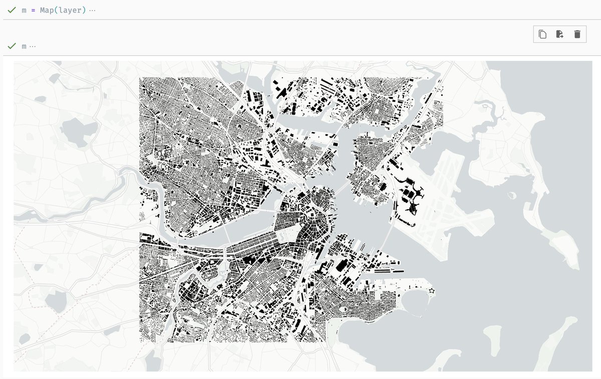
In just a few lines of Python code, query @OvertureMaps buildings and plot them with Lonboard. Making use of the latest work in @GeoParquet. New example: developmentseed.org/lonboard/lates…
Really excited to be joining @mbforr for my first livestream! Tune in on May 1st at 2p EDT for a discussion on spatial data visualization in Python, plus some nuggets of @GeoParquet and GeoArrow. Sign up here: linkedin.com/posts/mbforr_b…


released stac-cli v0.0.8, a command line interface for @STACspec. includes item creation, api search, and validation. feedback, feature requests, and (of course) bug reports welcome! 🙇♀️ github.com/stac-utils/sta…
📢STAC Browser v3.2.0 got released! github.com/radiantearth/s…
Coming soon: GeoParquet 1.1. cloudnativegeo.org/blog/2024/03/c… by @opencholmes
Another day in the tasking sprint! Lots of great discussion and work on backend and frontend implementations. I think it's coming together and we'll be wrapping up tomorrow!

🚀 Progress towards supporting efficient spatial queries in the @GeoParquet 1.1 spec, in Python, JavaScript, and Rust! It took 12 seconds to fetch this data from the 2.3 BILLION row Overture buildings dataset
We had a great STAC Night in Berlin today with more than 50 participants. Thanks to @planet for hosting us. We had many great talks and good discussions. The slides can be found below. I hope we can more of these events in the future. 🙃 cloud.mohr.ws/index.php/s/8o…
Learn how to query metadata from a @STACspec and geoprocess rasters from a collection within @duckdb by Alvaro Huarte. This #TutorialTuesday is a follow up from last week's which showed you how to integrating raster data into #DuckDB using the spatial ext linkedin.com/pulse/querying…

Creating commonly used identifiers and schemas are essential to making open data truly useful. Long exploration of this topic from @opencholmes and me at cloudnativegeo.org/blog/2024/04/c…
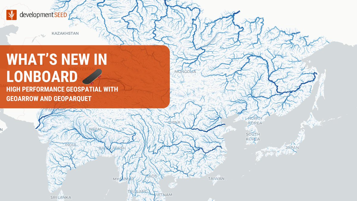
🛹 We've got Lonboard updates! 🗺️ New in v0.7: Supporting for more deck.gl layer types, GPU-based data filtering at 60fps, plus a CLI for quick visualizations & static HTML export. 🔗 ds.io/new-in-lonboard 1/12
Published initial Python bindings to a Rust implementation of fast, memory-efficient 2D RTree and KDTrees. *Yet another* project that's just a port of @mourner's awesome work. In this case the underlying buffer is zero-copy compatible with the originals github.com/kylebarron/geo…
GeoParquet 1.1 is coming soon: cloudnativegeo.org/blog/2024/03/c… New from @opencholmes on the @cloudnativegeo blog.
We merged support for storing GeoArrow data in @GeoParquet; to come in v1.1! This will make geometry I/O faster and provide spatial partitioning with no overhead. Thanks to @paleolimbot and @jorisvdbossche for driving this! github.com/opengeospatial…

Joe Morrison @mouthofmorrison
25K Followers 2K Following “Controversial industry figure” -@gridnews. VP @umbraspace 🛰 Satellite imagery for mapping 🗺, monitoring 📈, and 'mergencies 🚨
Qiusheng Wu @giswqs
38K Followers 5K Following Associate Professor @UTKGeography | @Amazon Visiting Academic | Senior Reseach Fellow @UNUINWEH | #EarthEngine GDE | Talk about #opensource #geospatial #dataviz
Even Rouault @EvenRouault
4K Followers 38 Following No longer here, but at @[email protected] Open-source software developer (GDAL, PROJ, QGIS, MapServer, ...).
Kyle Barron @kylebarr.. @kylebarron2
3K Followers 704 Following Creating the next generation of geospatial data tools for Python & the browser with GeoArrow, GeoParquet & GeoRust @developmentseed | he/him 🌈
Aravind 🌍 🛰 @aravindEO
7K Followers 1K Following Founder, @terrawatchspace Advisory & Insights | Earth Observation Consultant, Strategist & Communicator | Demystifying Satellite Data & its Applications 🌍 🛰️
Vincent Sarago @_VincentS_
3K Followers 3K Following @cogeotiff at @developmentseed - Creator of @RemotePixel - previous @Mapbox @effigis @CNRS - Bike activist
Robin Cole @robmarkcole
10K Followers 4K Following Tackling the worlds toughest challenges with AI & ML applied to satellite & aerial imagery https://t.co/QmbOWgdfAZ
Will Marshall @Will4Planet
21K Followers 871 Following Co-Founder & CEO of Planet -- building little spaceships to help us to take care of our favourite spaceship, the Earth :)
Will Cadell @geo_will
4K Followers 3K Following I could be skiing, I could be climbing. There might be code; there might be data. Continually amazed by the #geospatial magic created by my team at @sparkgeo
Tom MacWright @tmcw
15K Followers 2K Following engineer, writer, ‘art’ https://t.co/3SlHb4ZsAQ 🆕 https://t.co/PBTxrklWJ7 🌎 prev developmentseed, mapbox, observablehq, config all tweets are handtyped and lowercase
Max Lenormand @MaxLenormand
5K Followers 685 Following Data scientist at @overstoryai | I’m interested in maps, satellite images, tech & the people building them | Podcast : @MindsBehindMaps
Spatial Trouble Maker.. @Todd_Effin_Barr
10K Followers 7K Following Queer/ENBY AF 🏳️🌈🏳️⚧️ I work in the Natural Disaster/Climate/ESG Space, figuring out where Geospatial helps solve the puzzle. Unapologetic Ke$ha Fan
Ryan Abernathey @rabernat
7K Followers 2K Following Co-founder and CEO @EarthmoverHQ | Professor @columbia @lamontEarth | @pangeo_data steering council member (he / him)
Paul Ramsey @pwramsey
8K Followers 244 Following @[email protected] Loving open source software, practicing the piano, moving things around, working @crunchydata

@rjhale1971@fosstodon.. @rjhale
5K Followers 3K Following Owner of @northrivergeo . Enjoys adventuring, canoeing, and long walks on the beach while fixing data. #QGIS #POSTGIS #GDAL #GEOSERVER #CHATTANOOGA #HASHTAG
Keiko @Keiko_geo
11K Followers 4K Following PhD; VP of Science and Technology @climateengine; GDE @googledevs; #EarthObservation 🌳🌴🛰 #AI; #EarthEngine tips for #BetterFuture🌏; from 🗾; views my own
Dr. Tanya Harrison @tanyaofmars
58K Followers 11K Following Professional Martian 🔴 Former ops/science team @NASAPersevere @MarsCuriosity @MarsRovers+more 🚀 Co-Founder+CEO, Earth & Planetary Institute of Canada 🌈🇨🇦
MapScaping @MapScaping
39K Followers 111 Following The MapScaping Podcast is a #podcast for the #geospatial community. Just search for "MapScaping" Wherever you get your podcasts!
Bill Dollins @billdollins
5K Followers 704 Following Runner. Coder. Database hacker. Accidental geographer. Perpetual novice. Chaotic neutral. @geobabbler on Threads
who knows @Fktntlymkt1
0 Followers 231 Following
Ataeuss @ataeuss
27 Followers 56 Following
Jackeline Uhlich @JackelineU48388
77 Followers 5K Following
Janek Magnuszewski @jankomag
106 Followers 369 Following Melbourne-motivated 🗺 Urban Spatial Science MSc @CASAUCL
Mercy Wesselhoft @MercyWesse40434
34 Followers 5K Following
🌺🌸Katie🌺🌸 @biqqa21
121 Followers 311 Following Half the fun of the travel is the esthetic of lostness.🌊🌊 Refuse vulgar friendship, I will stop rude people
Yahaira Isom @iso_yahair
42 Followers 5K Following
Lisette Stallard @StallaLiset
69 Followers 5K Following
Alex Li @AlexWeiLiOZ
78 Followers 408 Following
Wonda Scheeler @ScheeleWo
71 Followers 5K Following
Oluwatuyi Samuel @OluwatuyiSamue5
1 Followers 72 Following
Morgan Krystek @kryst_mor
83 Followers 5K Following

Charlie Carnagey @CarnageCharli
76 Followers 5K Following
Rosa Malacara @rosa_malac
55 Followers 5K Following
Thich @Thich_5
28 Followers 516 Following
Hector Castellanos @HecCas96
27 Followers 224 Following

Eren YILDIRIM @1erenyildirim
63 Followers 350 Following PhD in Economics @YildizEdu Research Assistant @zaimuniv #econtwitter #economics #complexity #economicgeography
Gjore Milevski @gjoremilevski
60 Followers 122 Following
Sandra willams @SandraW85779
1 Followers 112 Following
Renaud Richardet @renaudrichardet
314 Followers 221 Following life cycle assessment, dad, software engineer, @[email protected]
Nga Sylvest @NgaSylve
26 Followers 5K Following

VonCannonTech @VonCannonTech
0 Followers 57 Following Software Shop. Mostly making private (E2EE), rugged, fast outdoor maps!
Victoria Gaines @VictoriGain
57 Followers 5K Following
Crimson Ninja @CrimsonNinNin
5 Followers 164 Following
Gisviking 🏳️�.. @GiSviking
86 Followers 506 Following A GIS explorer and student They/Them @[email protected]
Ailah Seltrecht @AilahSeltr61897
85 Followers 5K Following

Retha Viesselman @RViesselma14545
80 Followers 5K Following
Dorathy Devivo @DevivoDora79982
69 Followers 5K Following
Eddie Ruiz @Ed2uiz
147 Followers 2K Following
Malissa Borgstede @MalissaBor1099
79 Followers 5K Following


Zulema Oachs @OacZule
72 Followers 5K Following
TonalityData Visualiz.. @178918103
190 Followers 2K Following Data Visualization,QGIS,Blender,Houdini,Python,After Effects
Inaaya Borys @InaayBorys
54 Followers 5K Following
Roseanna Malvaez @MalvaezMalva
51 Followers 5K Following

Alia Chavez @chavez27613
46 Followers 5K Following
nemo13456 @nemo13456
3 Followers 38 Following
Adelaida Nein @n_adelai
60 Followers 5K Following

Kasandra Lillis @KasandraLi46380
41 Followers 5K Following
Getu Abdissa @getuabdissa
53 Followers 197 Following Tweets are my own. Retweets are not endorsements.
Me7a5hA @Me7a5hA
20 Followers 109 Following
Leoni Cosmo @CosmoLeoni2169
62 Followers 5K Following
Tony Griffiths @tonegriff
563 Followers 2K Following Holyheadian in Brentford. Researching & visualising clean energy projects: Co-founder @olsights
Qiusheng Wu @giswqs
38K Followers 5K Following Associate Professor @UTKGeography | @Amazon Visiting Academic | Senior Reseach Fellow @UNUINWEH | #EarthEngine GDE | Talk about #opensource #geospatial #dataviz
Even Rouault @EvenRouault
4K Followers 38 Following No longer here, but at @[email protected] Open-source software developer (GDAL, PROJ, QGIS, MapServer, ...).
Kyle Barron @kylebarr.. @kylebarron2
3K Followers 704 Following Creating the next generation of geospatial data tools for Python & the browser with GeoArrow, GeoParquet & GeoRust @developmentseed | he/him 🌈
Vincent Sarago @_VincentS_
3K Followers 3K Following @cogeotiff at @developmentseed - Creator of @RemotePixel - previous @Mapbox @effigis @CNRS - Bike activist
Tom MacWright @tmcw
15K Followers 2K Following engineer, writer, ‘art’ https://t.co/3SlHb4ZsAQ 🆕 https://t.co/PBTxrklWJ7 🌎 prev developmentseed, mapbox, observablehq, config all tweets are handtyped and lowercase
Paul Ramsey @pwramsey
8K Followers 244 Following @[email protected] Loving open source software, practicing the piano, moving things around, working @crunchydata
MapScaping @MapScaping
39K Followers 111 Following The MapScaping Podcast is a #podcast for the #geospatial community. Just search for "MapScaping" Wherever you get your podcasts!
Planet @planet
258K Followers 4K Following We see things from a different angle. 🛰️🕊️ Public Benefit Corporation on NYSE $PL
Arjen Vrielink @arjenvrielink
2K Followers 844 Following Owl at @satelligenceEO, RemoteSensing, OpenSource, theSwarm, Containers, Patterns. “Bacteria that turns shit into fuel” - the Mouth of Joe.
Bruno Sánchez-Andrad.. @brunosan
5K Followers 144 Following Data doesn’t change the world, people do (w/ data). Clay ED. Saepe cadendo. Dad to Sela and Paz w/ @emmyagsmith
Mykola Kozyr 🇺🇦 @MykolaKozyr
1K Followers 869 Following #StandWithUkraine Geospatial Product Management and Innovations. Currently at @satellitevu. Previously contributed to @UP42_ @eos_da
Sentinel Hub @sentinel_hub
39K Followers 472 Following A geospatial developer platform for EO data. Now a part of @Planet.
Brandon liu @bdon@mas.. @bdon
2K Followers 825 Following more map related tweets at @protomaps tooting @[email protected]
SeanGorman @SeanGorman
4K Followers 1K Following Paleo map nerd trying to create an alternate reality. Formerly GeoCommons, ESRI, Timbr, DigitalGlobe, Pixel8earth and Snap. Currently co-founder of https://t.co/cWk3ZuRTJZ.
gdal org @GdalOrg
5K Followers 7 Following No longer here. Find us at @[email protected] GDAL is a translator library for raster and vector geospatial data formats.

Zhuang-Fang NaNa Yi(�.. @geonanayi
2K Followers 2K Following PhD, Sr. Machine Learning Engineer #AI4Ag @RegrowAg. Previously #GeoAI @developmentseed& research scientist @ICRAF. Hobby artist 👩🏻🎨 @NaNaYi30989992

(Space) Case Taylor @spacecasetayl0r
4K Followers 1K Following VC by day, analyst by night // Analyzing the business of space @ https://t.co/d9KNLMA9Vv // Investing in space, semis, AI @ https://t.co/ct7PO94bQQ
Cory Doctorow NONCONS.. @doctorow
498K Followers 3K Following Author/activist/journalist. New novel: THE BEZZLE, a thriller of hi-tech fraud and the Shitty Tech Adoption Curve https://t.co/4ZExCQHv6q @[email protected]
creon levit @creon
6K Followers 868 Following @ NASA for 32 years Dir. of R&D @ Planet Labs since 2015 -- Science is poetry written about nature in the language of mathematics. -- Tweets are PERSONAL views
Mitchell Hashimoto @mitchellh
113K Followers 136 Following Working on a new terminal. 👻 Prev: founded @HashiCorp. Created Vagrant, Terraform, Vault, and others. Passionate about indie software.
Ash @AshFunction
948 Followers 4K Following AI/ML + geospatial @planet | e/ia | -e^iπ | space | optimism | jhana-explorer | qualia surfer | latent space photographer | ex @captricity AI @cal spectroscopy
Sugar Bowl Resort @sugarbowlresort
18K Followers 2K Following Sugar Bowl's Twitter delivers daily operation updates only, including lift status, parking updates & more. 100% resort update info & no fluff. #looknofurther
National Zoning Atlas @ZoningAtlas
953 Followers 151 Following The National Zoning Atlas is a collaborative of researchers digitizing, demystifying, & democratizing ~30,000 U.S. zoning codes. Join us at https://t.co/UFc56t7Dar
Yohan Iddawela @yohaniddawela
11K Followers 219 Following Sharing insights from the intersection of geospatial data science and economics | PhD in Economic Geography from @lsenews | Data Scientist @adb_hq
Taylor Baldwin @taylorbaldwin
4K Followers 1K Following co-founder @JamsocketHQ / @drifting_corp • YC W22 generative art • data vis • classical piano • 🏳️🌈 ex @datadoghq @uber @nytimes r&d
Luke Fischer @FischerLukeM
1K Followers 676 Following 🛰️☕️✈️ was in the Army, spent time at Uber Elevate, Joby, and Shield Cap before co-founding SkyFi.
World of Statistics @stats_feed
3.8M Followers 542 Following There are three kinds of lies: lies, damned lies, and statistics. We post statistics, polls, and ask questions. Sister page of @engineers_feed
Jack Kelly (@jack_kel.. @jack_kelly
6K Followers 4K Following Trying to help mitigate climate change using machine learning. Co-founder of @OpenClimateFix. Father. Previously @DeepMind & consulted for @NationalGridESO.
Darell van der Voort @darellvdv
205 Followers 546 Following Lead Data Engineer @VIDAplace. Building cloud-native geospatial & remote sensing solutions using open-source software 🗺️🛰️
Martin Davis @dr_jts_2001
15 Followers 48 Following
Josh Wills @josh_wills
18K Followers 2K Following Engineering at @datologyai; @duckdb enthusiast, ex-@slackhq
Source Cooperative @source_coop
261 Followers 2 Following A forthcoming data publishing utility from @OurRadiantEarth. Currently in beta.
Mark Litwintschik @marklit82
3K Followers 229 Following Consultant & author of https://t.co/HNdj0ZcIER
Max Gabrielsson @Maxxen_
198 Followers 226 Following Software Engineer @ DuckDB Labs Compiler/Database/Web/Distributed/Low-Level/Constraint/Geospatial/Parallel/Game/Systems/All-Around Programming
DuckDB @duckdb
13K Followers 3 Following DuckDB is an in-process SQL OLAP database management system. "DuckDB" and the DuckDB logo are registered trademarks of the DuckDB Foundation.
Cloud-Native Geospati.. @cloudnativegeo
955 Followers 113 Following Increasing adoption of cloud-native geospatial data.
Chris Josephs @Chrisjjosephs
24K Followers 1K Following Co-Founder @joinautopilot_ 💰 Run the @pelositracker_ ♟️
Scribble Maps @scribblemaps
4K Followers 118 Following Easily create, research, and share maps. Our mission is to make mapping accessible to all. Scribble Maps Status: https://t.co/wp6MZoHcC7
Spatial Informatics G.. @sig_gis
1K Followers 749 Following Spatial Informatics Group (SIG) is an Environmental Think-Tank working on Natural Hazards, Forest Carbon, Ecosystem Services, and Environmental Mapping
Nick St. Pierre @nickfloats
157K Followers 2K Following Creative Director and unofficial Midjourney shill. Publicly exploring AI & sharing learnings.
VCs Congratulating Th.. @VCBrags
242K Followers 4K Following They're adding value™ And they're very proud of it. @BragsVentures
STAC Index @stacindex
616 Followers 11 Following Find STAC Catalogs, APIs, Learning Resources, Software and Tools. Visit https://t.co/ZsH7liemGo Maintained by @matthmohr
Northstar Mtn Update @northstarmtn
34K Followers 51 Following Providing you with the most current information regarding mountain operations, traffic updates, and special events for @Northstar_CA (ACCOUNT DOES NOT REPLY)

@emilymbender@dair-co.. @emilymbender
58K Followers 2K Following Prof, Linguistics, UW // Faculty Director, CLMS // she/her // @[email protected] & bsky // rep by @ianbonaparte

Andrew Green @_andrew_green
5K Followers 1K Following Freelance Journalist. Currently in Berlin. Kentucky native.
Peter Reinhardt @reinpk
21K Followers 71 Following CEO @CharmIndustrial, previously CEO @Segment, MIT aerospace. Biggest fanboy of @embrein. Lots to learn.
Erika Reinhardt @embrein
4K Followers 221 Following Co-founder @sparkclimate catalyzing new climate solutions. Previously @Stripe, @planet, @OpenAI, @MIT, @USDResponse. Happy 👨👩👧👦👶 with @reinpk.
The Real GeoServer @GeoserverO
2K Followers 31 Following Proudly brewing geospatial data and maps since 2000. Free and Open Source!
GeoNode @GeoNode
3K Followers 286 Following GeoNode is an open source platform that facilitates the creation, sharing, and collaborative use of geospatial data.
SynMax Energy @SynMaxData
2K Followers 689 Following Next-generation energy market intelligence powered by big data, machine learning, and satellite remote sensing. @SynMaxInt
Sumer S. Johal @SumerJohal
200 Followers 166 Following Passionate about the role of Data for the global food ecosystem
Overture Maps Foundat.. @OvertureMaps
3K Followers 21 Following Collaborative effort to develop interoperable open map data for mapping services worldwide | @linuxfoundation open source project

Matt Ferraro @mferraro89
967 Followers 232 Following Aerospace engineer, software engineer, cat lover. Now trying to make a CAD program. Formerly @planet, @MIT and @NASA
OSU Geospatial Data A.. @GDAOSU
52 Followers 11 Following Geospatial Data Analytics group at the Ohio State University in the Department of Civil, Environmental and Geodetic Engineering (CEGE)
Alex Howard @digiphile
221K Followers 2K Following 🛠️Dad, cyclist, citizen💡🤳@CivicTexts ☀️@OpenGov 🇺🇸@ePluribusUnum🧵https://t.co/nrxqoVnkDW🦋https://t.co/0NtRgvFuCj 🐘 https://t.co/TO7r9qEOUB 📲4108499808

anotherjesse @anotherjesse
3K Followers 1K Following Parent, Permaculture, Ukulist, replicant @replicate, SatDat @planet, @OpenStack, UserScripts. I love the ocean, browsers, clouds & unicorns
SatSummit @sat_summit
1K Followers 361 Following May 16 & 17, 2024 Follow for updates #SatSummit2024
Randy Meech @randyme
13K Followers 806 Following Director of Engineering for Maps at Snap. My opinions disappear from my head as soon as you read them Trying out [email protected]
ingenieroariel @ingenieroariel
624 Followers 950 Following Geospatial Software Developer, my car is NixOS, Pythonista, (geo)Djangonaut, Happy husband, Proud father.

🧵After 16(!) years at @BessemerVP, I am leaving Bessemer and branching out to launch a new early-stage venture firm. 1/13
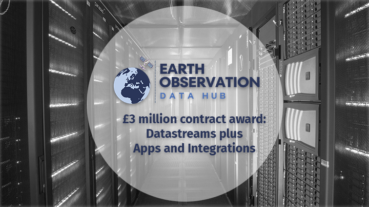
We are excited to partner with the wonderful folks at @sparkgeo on this project, which will leverage the power of eoAPI to bring more cloud-native geo to the UK.

EO DataHub awards £3 million to simplify access to Earth observation data🌍 👉tinyurl.com/mryec83y Welcome to our new EO DataHub partners @AirbusDefence, @AirbusSpace, @Earthi_, @sparkgeo, @spyrosoft and Oxidian #eodata #satellitedata #RemoteSensing #SatelliteImages
I am working on a new project Quickmaptools.com ... and it doesn't look anything like this image ;) feedback appreciated!

Learn about the #fiboa specification for standardized field boundary data in @GeoJSON & @GeoParquet! @opencholmes breaks down the core spect and its extensions in this blog post cloudnativegeo.org/blog/2024/04/f…
Its important to separate sci-fi from sci-fact when investing in the space industry I started Space Case 3yrs ago because there was too much fake news space stock analysis YouTubers and Reddit-ers saying “this stock is LITERALLY going to the moon” + people getting caught up in…

Can confirm that it is possible to use @WorldResources @Meta @landcarbonlab High Resolution Canopy Height Maps data as terrain tiles in @Mapbox
STAC Browser is now available in Portuguese, thanks to Douglas Uba from @inpe_mcti !
If you work in the satellite imagery industry you know what these are

Saw these while flying into Hokkaido. What are they?


I was an immigrant student with a big loan not too long ago, meaning I could barely attend any conferences with their registration rates. But, I hope current students/researchers can benefit from the discounted price (EUR 150) and attend EO Summit. Limited tickets available!

If you are a current student or researcher, you can now purchase a discounted ticket. Proof required on-site. Limited places only! Buy now at eosummit.com

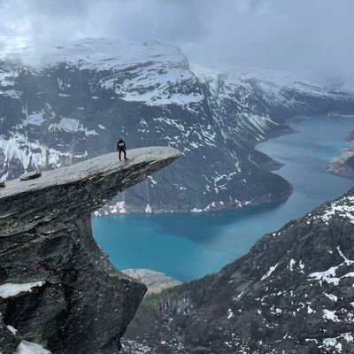
After the @N51Conference we hiked up Johnston Canyon to see some impressive waterfalls and the inkpots. Ice most of the way, good thing we rented spikes! #geonerdsonice


1/ Yesterday I gave a keynote at @N51Conference making the case on why EO data should be considered a common good and made free/accessible to all. As all common goods before it - colonialism and capitalism, both the root causes of climate change, are entrenched in the industry.


@rakyll I've talked to a few people who switched to engineering management roles years ago and are finding they can churn out little bits of working code again now because with LLM-assistance they can get something productive done in the much smaller amounts of available time they have
This was a ton of fun. Jed is an amazing host. Stick around for the discussion of OSM as the Fremen of mapping.
Dune: Part 3 is finally out! By which I mean the 3rd episode of @techsontexts focused on Dune is out. Thanks to @SeanGorman for doing this with me many months ago. This was a really fun conversation in which we discover that the @openstreetmap community is basically Fremen.
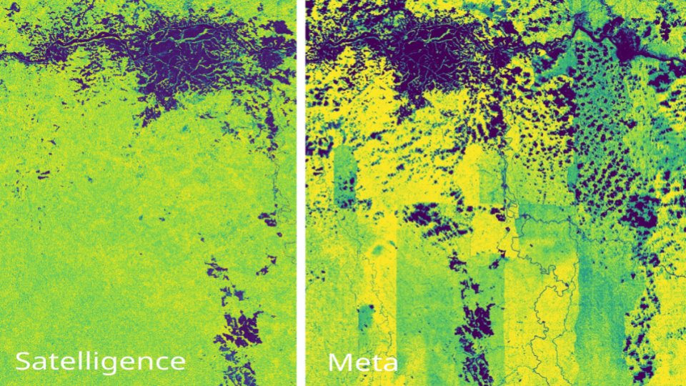
@gcamara @WorldResources Thanks for the quote / repost Gilberto. I have no problem with promoting the impressive feat of applying AI on global scale datasets. That is truly impressive. But I don't like the (unintended?) side effect that the hype leaks into the sustainability and climate or EO domains.
We had a look at the newest ~snake oil~ (pardon my French, can't help the vitriol) map of a supposedly global, thrilling, AI driven nanometer tree height map by @Meta and @WorldResources. This is what we found, a short thread:
Join me when I explain how to work with field boundary data on April 25. We'll show the fiboa CLI, how to load fiboa data in Python, and how to convert your own data to fiboa easily. On April 29 we'll explain how to use extensions to standardize field boundar data...
If you're interested to learn more about fiboa, join us for a live tutorial presented by @matthmohr on Thurs Apr 25 at 12pm ET. This demo will introduce you to the fiboa CLI. Register to attend here docs.google.com/forms/d/e/1FAI…
Announcing fiboa (Field Boundaries for Agriculture), a new project with Taylor Geospatial Engine focused on improving interoperability of farm field boundary data and other associated agriculture data cloudnativegeo.org/blog/2024/04/i…

@tmcw Not sure if it helps here, but @OvertureMaps water data contains coastline water polygons - labeled as "ocean" alongside all other water polygons (and lines/points). Same data as from Daylight coastlines.

Trends for United States
You might like