
Vexcel Data Program @vexcel_data
Aerial imagery & geospatial data for government and businesses. vexceldata.com Joined March 2021-
Tweets430
-
Followers93
-
Following0
-
Likes0
When it comes to #aerialimagery, scale changes everything. Especially when comparing imagery collected by aircraft vs. drone. You need more than just a quick view; you need a reliable baseline. Found out why 👉hubs.la/Q03LJ9Hy0 #imagery #AerialvsDrone #AccuracyMatters

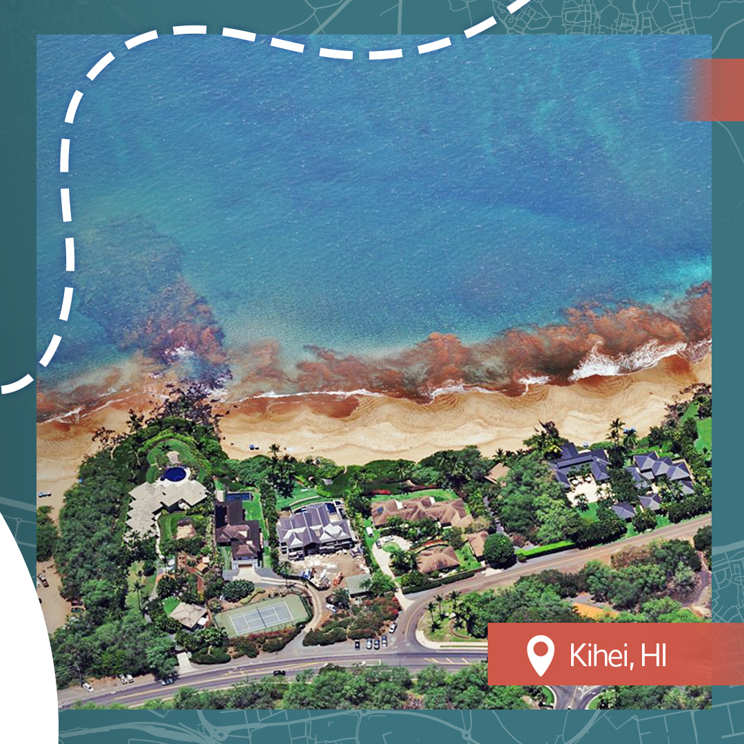
Wondered what our #aerialimagery looks like in Hawaii? We collect imagery in urban areas across the islands, helping you see the Aloha State like never before. Check out our coverage map of Hawaii and view available products 👇hubs.la/Q03Ly9WT0


Vexcel's API 2.0 helps turn aerial imagery into instant property intelligence. From real-time access to seamless integration and scalable search, it’s changing how many industries unlock AI-powered insights. Discover the top 3 ways it delivers 👉hubs.la/Q03LlrMg0

For Beautiful Earth we're saying aloha, bonjour, and hallo to this week's discovered locations. 👉hubs.la/Q03L4DXD0 #BeautifulEarth #AccuracyMatters #AerialImagery


State coverage in the U.S. is a key benefit to our #aerialimagery program. We collect in the Lower 48 plus urban areas in Hawaii. Have you seen our coverage in North Carolina? We collect in all 100 counties at a resolution of 7.5-15cm. 👉hubs.la/Q03KQ1V20


Keeping up with property change is hard. Vexcel makes it easier. Discover how Vexcel helps tax assessors modernize with high-res aerial imagery and AI insights that reveal what's new, what's changed, and what matters most. 👉hubs.la/Q03KCFKw0

Day 2 at IAAO 2025 is already underway and our team would love to connect on this last day of Exhibit floor! Make sure to drop by Booth 109 before 5 p.m. and join the conversation of tackling major challenges for assessors with reliable #aerialimagery, #AI analytics, and more.

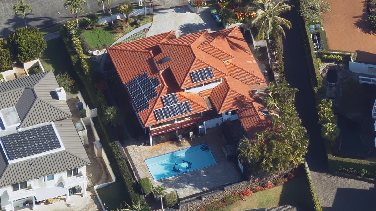
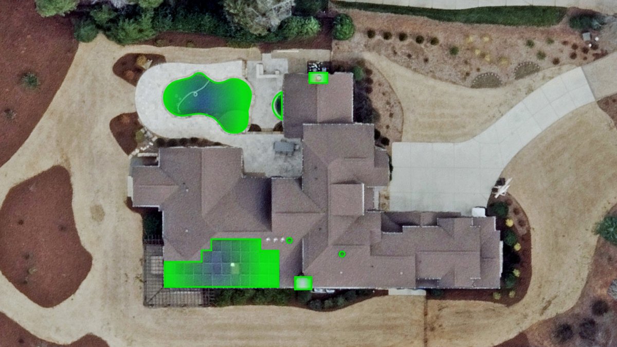
Every roof tells a story and Elements AI can read it. From shingles to solar panels, Vexcel’s AI extracts attributes from high-res aerial imagery anyone can use to understand property risk confidently. 👉 See how rooftop intel delivers sharper insights: hubs.la/Q03KknrF0

We're here at #IAAO2025 this week, ready to connect with assessors from around the U.S. needing data and analytics to support their workloads. Make sure to drop by Booth #109 during the conference to find out how we help tax assessors see and do more. 👉hubs.la/Q03KjRRm0

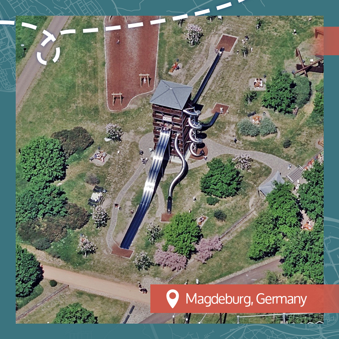
For this week's #BeautifulEarth imagery, we're weaving you in and around stunning areas of Europeand (and a couple of other places). What catches your eye? 👉hubs.la/Q03K75XD0 #aerialimagery


When looking for #aerialimagery that gives you the views you need, in the places you want, at a resolution that helps you make better decisions, you need to look no further than our own library. Learn more about the world's largest aerial imagery program: hubs.la/Q03J_qXr0


Our team is in Nashville, TN, this week for NSGIC 2025, ready to meet with State GIOs. Connect with us about our coverage, quality, accuracy, frequency, and #AI insights needed to make smarter decisions. Elevate your #GIS program with Vexcel data 👉hubs.ly/Q03JlNtG0

Do you know the differences between satellite imagery and aerial imagery? It can make or break a project depending on the level of detail, quality, and consistency needed to make confident decisions. View our comparison to learn more 👉hubs.la/Q03JlBfX0
Take a journey through our weekly Beautiful Earth aerial imagery with us as we discover from above fascinating finds in Spain, Switzerland, Sweden, and the UK! 🌏 hubs.la/Q03J8qny0


Will we see you at IAAO 2025 in a couple of weeks? Our team is looking forward to connecting with you! Tax assessors need clarity and accuracy — and that’s exactly what our data program delivers. 📍 Meet us at IAAO 2025 in Booth 109 👉 Explore more: hubs.la/Q03J5bFw0
What do you need when you have thousands of miles to manage for corridor mapping? You need high-resolution aerial imagery and reliable geospatial data to enhance your monitoring and planning. 👉hubs.la/Q03HZftm0

Vexcel is headed to NSGIC 2025 next week! State GIOs face growing demands to use reliable geospatial data for their communities. Access nationwide aerial coverage, AI-derived property insights, and more. Learn more about our government solutions here: hubs.la/Q03HDDLg0

🔥 Imagery available for the TCU Lightning Complex Fires 🔥 Our Gray Sky team has published high-res ortho and multispectral #aerialimagery for the fires burning in California. Imagery is available via Vexcel and partners. More information at 👉hubs.la/Q03HFdTW0 📷:

We collect aerial imagery year-round, building out our robust library of aerial data so customers have access to the information they need. In U.S. urban areas, we collect up to 3x/year. Why is this important? Take a read to learn more: hubs.la/Q03HyS0w0

Gray Sky Alert: 🔥TCU Lightning Complex Fires Oru Gray Sky team collected imagery today for the many wildfires that have burned nearly 14,000 acres in Tuolumne and Calaveras counties in California, destroying dozens of structures. Watch for updates: hubs.la/Q03HrSyp0


Unexplained Daily @akd087
68 Followers 312 Following Posting thoughts and updates on true crime and the unexplained daily.
Etweto @Etweto847
55 Followers 584 Following
AtNight Management @AtNightMGMT
14 Followers 36 Following AtNight Management • Relaunch 2026 | a One World Corp. • 𝑈𝑛𝑢𝑠 𝑀𝑢𝑛𝑑𝑢𝑠.
One World Society @WelcomeOneWorld
2K Followers 25 Following a MULTI-NATIONAL INFORMATION TECHNOLOGY COMPANY, GLOBAL NEWS SYNDICATE & CREATIVE INTELLIGENCE AGENCY. Unus Mundus.
Kat Wright @KatKat4224
66 Followers 55 Following Gold Star Wife, Mother. Grandmother, Dog Mom, Mentor, Social Worker, Case Manager, Advocate.
Augohfirp @Augohfirp01841
50 Followers 329 Following
Near Space Labs @NearSpaceLabs
930 Followers 214 Following Making high-quality Earth imagery and geospatial data widely accessible.
rakesh ravindran @rakesh__ravi
0 Followers 23 Following

Curtis McDonald @cmcdonald_wx
582 Followers 811 Following Meteorology grad from @ousom. Thunderstorm and winter weather enthusiast. @PivotalWeather managing partner. Product Director @CoreLogicInc.
𝔽𝕚𝕣𝕖 ℝ�... @FireRstntLdscpg
143 Followers 1K Following Landscape Architect with a background in wildfire ecology & wildland fire fighting. Site Planning, Planting & Irrigation Design for your rural property.
Nahel Belgherze @WxNB_
64K Followers 3K Following Mainly focused on covering extreme weather events worldwide. Also interested in climate dynamics, geohazards and satellite/airborne remote sensing.

Jon Landauer @JonLandauer
439 Followers 2K Following Masters Student (Geography). Interests: Maps, Demography, Elections, Art + Design. Fan of Memphis-Milano furniture, Yoshitomo Nara and Louis Wain.
Daniel Lavor Limeira @LavorDanie40501
19 Followers 956 Following
Matt Down @matthdown
1K Followers 5K Following Husband, father, Proposal Consultant, maps, craft beer, donuts. Comments are mine.
DANIYAL @haider5d
168 Followers 4K Following
Amy Orton @Amy_Leigh_O
6 Followers 46 Following
Alternem @alter_nem
1 Followers 60 Following Designer, Digital AI Hobbyist, Real Estate, 3D Creative Experience
Ogochukwu @Ogochukwu611001
263 Followers 7K Following The first thing you should know about me is that I'm not you.A lot more will make sense after that.💰
Bernhard Rannegger @BRannegger
82K Followers 1K Following Founder ScyAI | Extreme Sports Athlete | Building a compound system of AI teammates working to identify, quantify & mitigate physical business risk 🌊🔥🌪️
Syed Muntazir @geomuntazir1
92 Followers 1K Following
Surveyors @surveyors85
0 Followers 127 Following
Akira Sugiyama @_akiras
5K Followers 3K Following Business Development Director, Unreal Engine, Epic Games Japan / I love VFX breakdown / We succeed when you succeed!
南北車 @chechekk
335 Followers 272 Following
regiser @Iamregiser
47 Followers 3K Following
softyoda @softyoda
474 Followers 3K Following #floss #photogrammetry Ecology of ontology, Alignment via enlightenment, Cahos observer
gisworld-tech @GISWorld_de
196 Followers 77 Following GISWorld contains GIS, Python tutorials for geospatial uses. In addition, the Contests announcement related to Geoinformation, Geodesy, surveying engineering.

valeriano cossu @_ValerianoCossu
78 Followers 1K Following Also a Golang developer. C++ only if strictly necessary.
techris.eth @techris45
182 Followers 2K Following
Jack zhao @Jackzhao1973053
4 Followers 360 Following
Braulio Otavalo @BraulioOtavalo
257 Followers 5K Following AI consultant for digital transformation projects and ML applications to the industry.
L君 @alangzh
14 Followers 195 Following
OSCity @OSCityNL
841 Followers 4K Following Technology and cities - open design, science, culture etc. Building @ArchiyouApp
Sniffer_sun @Sniffer_sun
168 Followers 3K Following

GeoLibra @leihuang_gis
14 Followers 148 Following
orhan @orhanmehmet2024
15 Followers 898 Following
yunjinzh @yunjinzh
312 Followers 2K Following
tsirilos 🇺🇦 @tsirilos
2K Followers 6K Following Ματαιωμένος ευδαιμονισμός - Μπατηρημένη καύλα - Συνειδησιακή οσφυοκαμψία - Αξιακός Αναδασμός - Πολιτική αρτιότητα κατά παρέκκλιση. Ελεύθερος αγοραίος.
dhrxl @Dhairyasheel_J
81 Followers 1K Following
David Justiniano @elchusti
32 Followers 3K Following

Nils Nielsen @NilsNielsen10
155 Followers 6K Following

💙 De.Fi Army | (�... @Hotaru_nat
140 Followers 2K Following #MintSquare, (☁️, ☁️)⚙️, @0xJoint ⚙️ ❤️ Memecoin #BlueMove #MOVErs https://t.co/XktODI51tw Link3 KCZ5RLTF UMHSFJM6
Guia Techno @guiatechno21
35 Followers 941 FollowingTrends for United States
You might like