-
Tweets22K
-
Followers54K
-
Following273
-
Likes6K
Surge flows are a rare phenomenon where shallow waters, sand or sediment, and steep topography combine to create waves in rivers. #geography buff.ly/4b9uN5o
When rivers become ice roads #geography buff.ly/2VSxrr1
Tracking penguin colonies through their droppings #WorldPenguinDay buff.ly/389OwBH
King penguins like to maintain just the right amount of personal space #WorldPenguinDay buff.ly/3dVf90f
Will cool air pooling protect some forests from climate change? #geography buff.ly/3Uby8tX
Meta and the World Resources Institute launched a global tree canopy height map at 1-meter resolution, using AI to detect single trees worldwide. The data and AI models are being made freely and publicly available. buff.ly/4b8utUI
Research highlights how GIS and remote-sensing techniques can be used to evaluate and map areas that are suitable for bee populations. buff.ly/4b1ciQq
Researchers used historical photographs, some dating back to the mid-19th century, to analyze changes in landscapes. buff.ly/3vY5a8H
Discover how to make maps glow with firefly cartography with this QGIS tutorial by @Svelte_mo #GIS #geospatial buff.ly/4aWXfrg
Haboobs, also known as convectively-driven dust storms, are intense, large-scale dust storms that occur in arid regions in the United States. #geography buff.ly/3FVnlg8
Researchers are using Earth observation satellites to track changes to the global water cycles. #geography #geospatial buff.ly/3Y8D96N
Researchers analyzed 10,000+ satellite images taken from 2014 to 2021 to measure the seasonal velocity of 105 glaciers on the Antarctic Peninsula. #geospatial #geography buff.ly/3IYkWnE
California's wet winter rains help drive the simultaneous blooming of a large number of wildflowers in the state's desert regions. #geography buff.ly/3yTogLj
Scientists propose using sensors on wildlife to collect fine-grained weather data about the environments these animals move around in. #geography #geospatial buff.ly/4cVeI55
Researchers used synthetic aperture radar (SAR) data from colocated satellites to estimate tree canopy height. #geospatial #geography buff.ly/43gqIK9
UniTS was developed as a versatile tool that can handle a wide range of time series tasks without the need for time-consuming and individualized adjustments. #GIS #geospatial buff.ly/49WK9u3
Based on a study of 135,153 vascular plant species, scientists predict 33-68% of global land will undergo major phytoclimate changes by 2070. #geography buff.ly/4aBBe1f
Human-driven extinction of birds buff.ly/43SMnYW
New GIS job posted: * GIS Functional Analyst ~ Lincoln, NE, USA ~ Closes 23-April-2024 For information about this and other GIS jobs visit: buff.ly/41royqd
New GIS job posted: * GIS Analyst ~ Tacoma, WA, USA ~ Closes 7-May-2024 For information about this and other GIS jobs visit: buff.ly/41royqd

Qiusheng Wu @giswqs
38K Followers 5K Following Associate Professor @UTKGeography | @Amazon Visiting Academic | Senior Reseach Fellow @UNUINWEH | #EarthEngine GDE | Talk about #opensource #geospatial #dataviz
🥔🗺️ ᴘᴏᴋ.. @pokateo_maps
25K Followers 3K Following 👋🏻 I'm Kate ᵉᵃᵗᵉʳ ᵒᶠ ᵖᵒᵗᵃᵗᵒᵉˢ ᵃⁿᵈ ᵐᵃᵏᵉʳ ᵒᶠ ᵐᵃᵖˢ 🌐 I make #geospatial & #GIS (more) fun by sharing #mappymeme s & #maptastic themes. Hosts #GISchat. ᵛᶦᵉʷˢᵐᶦⁿᵉ
Matt Malone @MatthewHMalone
7K Followers 597 Following GIS Professional/GIS meme aficionado | Geography, geology and weather geek | 🐘 https://t.co/tZmoBPjeig; 🦋https://t.co/7nMrtkx5sH
josephkerski @josephkerski
14K Followers 2K Following Geography, geo-geekiness, STEM, ed tech, space, place, geographic information systems (GIS), GPS, outdoor education 365 days a year.
Esri Training @EsriTraining
33K Followers 1K Following Advancing geospatial capabilities of individuals, teams, and organizations is our mission and our passion.
Spatial Trouble Maker.. @Todd_Effin_Barr
10K Followers 7K Following Queer/ENBY AF 🏳️🌈🏳️⚧️ I work in the Natural Disaster/Climate/ESG Space, figuring out where Geospatial helps solve the puzzle. Unapologetic Ke$ha Fan
Kurt Menke - geomenke.. @geomenke
8K Followers 2K Following Danish Resident 🇩🇰 | @SeptimaDK | FOSS4G user/advocate/educator | Author: Discover QGIS 3.x 2nd Ed. | Co-author:QGIS for Hydrological Applications 2nd Ed.
fosstodon.org/@klaska.. @klaskarlsson
8K Followers 87 Following SwAF working with geosupport in the field and in systems developement. Here I mostly write about things that interest me when I'm not at work. Open Sources.
michael GOULD (@mgoul.. @0mgould
11K Followers 3K Following GIS professor and Global Education Manager at Esri (opinions my own). #travel #mountainbike #internationalDev #GIS #Spain #sarcasm
منصة نظم ال�.. @gis_eductation
10K Followers 5K Following نهتم بنظم المعلومات الجغرافية | GIS | نشر المعرفة الخاصة ب GIS | مؤتمرات | ورش العمل | كتب GIS | المنتديات | GPS | #اعلانات_دورات_GIS #اعلانات_كتب_GIS
ʟᴀɴᴅ sᴜʀᴠ�.. @LandSurveyorsU
9K Followers 590 Following ʟᴀɴᴅsᴜʀᴠᴇʏᴏʀsᴜɴɪᴛᴇᴅ.ᴄᴏᴍ #ʟᴀɴᴅsᴜʀᴠᴇʏᴏʀs ᴛᴀᴘ ɪɴᴛᴏ ᴛʜᴇ #sᴜʀᴠᴇʏɪɴɢ ᴇxᴘᴇʀɪᴇɴᴄᴇ ᴏғ ᴏᴠᴇʀ 21ᴋ #sᴜʀᴠᴇʏᴏʀs ɪɴsɪᴅᴇ ʟᴀɴᴅ sᴜʀᴠᴇʏᴏʀs ᴜɴɪᴛᴇᴅ ᴄᴏᴍᴍᴜɴɪᴛʏ. ᴊᴏʙs, sᴜᴘᴘᴏʀᴛ & ᴍᴏʀᴇ ✊
MappingGIS 🚀🌍 @MappingGIS
23K Followers 308 Following Formación que impulsa tu perfil GIS. Cursos online de #QGIS #R #ArcGIS #PostGIS #webmapping #python #GeoServer #OpenLayers #Leaflet #gisenlanube #teledeteccion
Wanmei L 🌎🛰️ @MapsbyW
3K Followers 303 Following Science Data Visualizer at NASA 🌎 🛰️ 🗺️ | UCLA Alumni 🎓 | Visual Storyteller 📚 | Cartographer 🧭
USGS Landsat @USGSLandsat
37K Followers 214 Following Official USGS account for the Landsat Program - a series of Earth-observing satellites co-managed by @USGS & @NASA. Imaging the Earth since 1972.📡🛰️
Esri GIS Education @GISEd
20K Followers 728 Following Esri GIS Education - news, curriculum, software, tools and more
د. نواف العت.. @Alotaibi_Nawaf3
10K Followers 79 Following مدرب، مستشار و مؤلف في: GIS & حل المشكلات. | الماستر والدكتوراه في #نظم_المعلومات_الجغرافية/ @UniversityLeeds 🎯
Hans van der Kwast @h.. @hansakwast
7K Followers 2K Following Associate Prof. @ihedelft | Physical Geographer | Owner of QWAST-GIS | #OpenSource advocacy | board member @qgisnl | @gisocw | @osgeo Charter Member | #QGIS
Helen McKenzie @helenmakesmaps
12K Followers 1K Following Data & geospatial advocate, content creator & all around map geek @CARTO🌍🌐🗺 Likes: cheese on beans on toast, sitting, otters. Views mine. she/her.
Humanitarian OpenStre.. @hotosm
29K Followers 3K Following 🗺️ Global Humanitarian OpenStreetMap Team. #OSM for humanitarian response and community-led development.
Craig Taylor @CraigTaylorViz
12K Followers 791 Following Data Visualisation Design Manager @Itoworld
who knows @Fktntlymkt1
0 Followers 117 Following
Bro @KeysnoDoors
0 Followers 35 Following


OGUNAJO DAMILARE @OgunajoD
80 Followers 410 Following Experienced Music promoter, Social media campaign manager, & Email Marketer specializing in digital marketing strategy and campaign execution.
Beyza İrem Akdoğan @beyzaia
4 Followers 31 Following


Cramer @cramepie
42 Followers 292 Following
Figure Eight Federal @F8Federal
86 Followers 221 Following Confidence to deploy world class AI. https://t.co/FuKxxeuIAW

Vasilis @capvasilis
82 Followers 626 Following

Orlin Chotev @OChotev
168 Followers 198 Following
Ben @bentrayn0r
64 Followers 197 Following
Berekum Biligon @BerekumB
2 Followers 32 Following
Nyamihana Camille @nyamihanacamil2
172 Followers 861 Following Environmental and Climate Change Practitioner and Passionate..., Managing Director @ Intime Green Life Company Ltd ( IGLC Ltd)# A Green Earth is a Green Life...

not a 🌸🐝🌻�.. @hoyasec
126 Followers 417 Following Georgetown SFS, formerly USMC. Support minorities. Stop Asian Hate. 日本語👌七転八起
Kelly McGuire @GeoLingual
9 Followers 140 Following Gibraltarian writer/editor/translator living in the Netherlands. Thinking about studying for an Open University degree in geology and environmental science.
InnovateX Hub @InnovateXHub
11 Followers 209 Following InnovateX Hub is a driven Rwandan - based Company that aims to empower a sustainable tomorrow through geospatial excellence.
geeksguide @geeksguidenet
163 Followers 2K Following
Nori Ganapathi Kumar @GanapathiNoor
29 Followers 128 Following 🥰life 🧬 science...... Geo..... Anglo..... Botanist
Anthony Randall-Claus.. @MWGeospatial
0 Followers 131 Following
Elamin @ElaminAbdelgal
20 Followers 278 Following final year pharmacy student, interested in research and publishing of pharmacy related scientific paper

DANIEL MIHALACHE @DANIELM60729703
614 Followers 6K Following

Tito valverde @Titovalverde5
2 Followers 164 Following
Anurag Yadav @anuragy82731274
1 Followers 128 Following

tao niu @sdyidu
45 Followers 310 Following

محمد بن أحم�.. @mohamedpt9
12 Followers 800 Following الحمد لله اللهم ارحمني وسددني واهدني استغفر الله

Somnath Mukherjee @Tr_Somnath
6 Followers 39 Following

Andrés Cardona @andres_cardon7
236 Followers 2K Following En este perfil somos un remix musical. Acá decimos pamdebono y chuspa.
Yamini Sahu @yamini070895
5 Followers 92 Following Research Scholar @IISER Bhopal, #Geospatialdatascience, #Python, #Googleearth
Erik DeVaun @Whitelobster1
0 Followers 1 Following
danyellson @danyellson10
1 Followers 32 Following

Learn what I Don't kn.. @AdarshKM_DNM
5 Followers 33 Following Truth Only Only Post what i don't Know

Rodney 🦅✌🏾 @didi_jrK8
797 Followers 3K Following Environmental Scientist 🌍 and Entrepreneur | @chelseafc 💯| Isaiah 60:22✨| Till you own your own you can’t be free🖤
Lapaznoesblanca @lapaznoesblanca
6 Followers 156 Following Hacemos memoria histórica por medio de mapas. We create a memory of History through maps.
Juan Carlos Ocampo�.. @JCarlosOcampo
296 Followers 3K Following 👨🏽💻💾Oracleano, Harboriano y SodaStereano
TMS Technologies @TMSTechCo
3 Followers 16 Following Pioneering the Future: Revolutionizing Transportation with Intelligent Solutions.
🥔🗺️ ᴘᴏᴋ.. @pokateo_maps
25K Followers 3K Following 👋🏻 I'm Kate ᵉᵃᵗᵉʳ ᵒᶠ ᵖᵒᵗᵃᵗᵒᵉˢ ᵃⁿᵈ ᵐᵃᵏᵉʳ ᵒᶠ ᵐᵃᵖˢ 🌐 I make #geospatial & #GIS (more) fun by sharing #mappymeme s & #maptastic themes. Hosts #GISchat. ᵛᶦᵉʷˢᵐᶦⁿᵉ
josephkerski @josephkerski
14K Followers 2K Following Geography, geo-geekiness, STEM, ed tech, space, place, geographic information systems (GIS), GPS, outdoor education 365 days a year.
Esri @Esri
193K Followers 70K Following Esri builds #ArcGIS, the leading location intelligence and spatial analytics software for mapping, 3D GIS, imagery, and geospatial app development.
Spatial Trouble Maker.. @Todd_Effin_Barr
10K Followers 7K Following Queer/ENBY AF 🏳️🌈🏳️⚧️ I work in the Natural Disaster/Climate/ESG Space, figuring out where Geospatial helps solve the puzzle. Unapologetic Ke$ha Fan
Topi Tjukanov @tjukanov
21K Followers 2K Following Makes maps. Works at @Mapbox. Started #30DayMapChallenge.
michael GOULD (@mgoul.. @0mgould
11K Followers 3K Following GIS professor and Global Education Manager at Esri (opinions my own). #travel #mountainbike #internationalDev #GIS #Spain #sarcasm
USGS Landsat @USGSLandsat
37K Followers 214 Following Official USGS account for the Landsat Program - a series of Earth-observing satellites co-managed by @USGS & @NASA. Imaging the Earth since 1972.📡🛰️
QGIS @qgis
67K Followers 72 Following Official account of QGIS - the user friendly Open Source Geographic Information System
Humanitarian OpenStre.. @hotosm
29K Followers 3K Following 🗺️ Global Humanitarian OpenStreetMap Team. #OSM for humanitarian response and community-led development.
MapScaping @MapScaping
39K Followers 111 Following The MapScaping Podcast is a #podcast for the #geospatial community. Just search for "MapScaping" Wherever you get your podcasts!
NASA Landsat @NASA_Landsat
80K Followers 470 Following The NASA/USGS Landsat series of Earth-observing satellites has monitored our planet for over 50 years. Verification: https://t.co/4p9BhINXeQ
Women In GIS @womeningis
5K Followers 198 Following Promoting, Supporting, Encouraging, Building, Leading - Women In GIS
Mapbox @Mapbox
77K Followers 2K Following Mapbox powers navigation for people, packages, and vehicles everywhere.
Sisters of SAR @SistersofSAR
10K Followers 4K Following A passion for all things #SAR | #WomeninSAR | @eoscenefrom | We 💜@LadiesofLandsat & @DamesofDrones| Tweets by @LDR1, @SAR_ahBanks, @Go__Pika & @ant_dasgupta |
American Association .. @theAAG
29K Followers 2K Following AAG is an academic & professional organization representing educators, researchers, & practitioners in geography. Also at https://t.co/7KuoPU1QYB
Emmanuel Jolaiya @jeafreezy
3K Followers 4K Following Earth Observation 🛰 & Geospatial Software Engineer. Building @spatialnodehq,Tech. @sotmafrica, Co-host @africageoconvo. Msc. student @mastergeotech Focusing 🎯
The GIS Girl | Geo Vi.. @TheGISGirl
663 Followers 90 Following Training/resources for women to increase awareness in geo | by @geoluminousCo | 📚1st geo Distance Learning Academy | 🇺🇳SDG 4️⃣ and 5️⃣ | Follow progress 🔗⬇️

Women in Copernicus @WomenCopernicus
3K Followers 2K Following #WomeninCopernicus - A European action to identify & give a voice to the women working on 🇪🇺 #Copernicus #EarthObservation #space 📺 https://t.co/WMOOlfTp3e
Women+ in Geospatial @geospatialwomen
10K Followers 304 Following An inclusive and global community that inspires, unites and empowers women+ in the geospatial field to become strong leaders and changemakers! Join us👇today!
Geochicas @GeochicasOSM
7K Followers 1K Following Grupo de mujeres mapeadoras de #OpenStreetMap y @osgeo. Trabajamos para cerrar la brecha de género. #OSMintegra #WomeninTech #DiversityInGeo
Women in GIS Kenya (W.. @WiGISKe
2K Followers 503 Following We use data to champion for gender equity | First @OSGEO lab in East Africa | Partner of @Data4SDGs |Contact: [email protected]
NorthStar of GIS: Peo.. @gisNorthStar
846 Followers 563 Following Increasing #BlackRepresentation and #RacialEquity in #geography, #GIS, and #Geospatial #BlackInGIS #MelanatedAndMapping #MelanatingGeography
Mvano Jr @mvanorashid
572 Followers 559 Following Data Scientist | Information Designer | GIS & Carto Expert : Analysing and Crafting data story ,Solving Spatial Problems.
TwitCount @twitcountapp
10K Followers 0 Following Unofficial share counts calculator that counts the number of times a URL was shared on Twitter - Not affiliated with Twitter
Scene From Above Podc.. @eoscenefrom
3K Followers 198 Following Official tweets from the Scene From Above podcast - Earth observation, remote sensing, geospatial and geeky chat @flasmendes @yhasmoura @Michelle_Picoli
Geoawesomeness @geoawesomeness
26K Followers 6K Following Open and inclusive community platform for geospatial experts and enthusiasts. Building bridges across sectors and industries. All things GEO awesome 🌎 🛰🗺🚀
Cat Explore @catexplore
2K Followers 3 Following Explore the fun, quirky, and curious world of cats.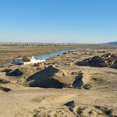
Mark Altaweel @maltaweel5
1K Followers 1K Following Prof. Near East Archaeology & Archaeological Data Science UCL, Vice-Dean Innovation & Enterprise SHS UCL, Visiting Prof ADU, Social Enterprise
Placekey @placekeyio
706 Followers 423 Following The free, universal location identifier for physical places. Learn more about Placekey's universal places ID API: https://t.co/DGy6MO1wQc
Ilya Boyandin 🇺�.. @ilyabo
1K Followers 2K Following @[email protected] geo data visualization engineer at @unfoldedinc. creator of https://t.co/Tx1sLywvQz. past @teralytics @ixt @unifr @sunmicrosystems

GIS for Higher Educat.. @GIS4HEd
843 Followers 369 Following Follow us for insights, news, and updates on GIS in higher education and research. Managed by @esricanada Education and Research Team.
Artlembo @artlembo
516 Followers 17 Following Professor at Salisbury University, and worked with GIS since 1985. I mostly use @esri, @postgis, and @manifoldgis https://t.co/e2i4QjYuZo and https://t.co/SdvteZyKO4
AWiGIS @africwomeningis
3K Followers 180 Following African Women in GIS is a community made up of African women who are in the geospatial industry.
BlackGirlsMapp @BlackGirlsMapp
1K Followers 103 Following Celebrating & connecting marginalized communities; using GIS to investigate social issues & empower change. Opinions may not reflect Esri's views.
Dr. Tanya Harrison @tanyaofmars
58K Followers 11K Following Professional Martian 🔴 Former ops/science team @NASAPersevere @MarsCuriosity @MarsRovers+more 🚀 Co-Founder+CEO, Earth & Planetary Institute of Canada 🌈🇨🇦
Greg Bunce @bunce_greg
173 Followers 1K Following thinking and writing all things spatial. also double as a human, a believer, and an aspiring early riser. working in geospatial since 2003. work at @MapUtah
Dr Karen Joyce @DrKJoyce
4K Followers 2K Following #RemoteSensing @JCU | Ed Director @SheMapsau | Creator @GeoNadirAu | @DamesOfDrones
Jon Haycox @optimiseEVQ
170 Followers 662 Following GIS, groundwater, floods and SuDS. Craft beer lover. Hiking enthusiast.

World Geospatial Indu.. @WGICouncil
2K Followers 298 Following Advancing the role of the geospatial industry and strengthening its contributions to society and the global economy.
Geo @GeoOpenAccess
1K Followers 377 Following Geo is the @RGS_IBGhe’s fully open access journal, publishing geographical and environmental research of international significance. @WileyOpenAccess
PROBA-V @PROBAVegetation
1K Followers 127 Following PROBA-V, the satellite for global vegetation monitoring. ESA’s minisatellite monitors our Earth’s surface every day and is operational since 2013.
TheGeoScholar @GeoScholar
375 Followers 254 Following Promoting geography, geology, meteorology, and other geosciences. #earth #geographyisbroad #geographyisdynamic #geosciences #earthscience
Ordnance Survey @OrdnanceSurvey
64K Followers 3K Following Britain's mapping agency. Helping you #SeeABetterPlace with world-leading location expertise. Get outside with @OSLeisure. Online 9-5 Mon-Fri.
PPGIS @ppgis
3K Followers 1K Following Public Participation GIS #PPGIS | Participatory GIS #PGIS | 2007 @WSAoffice World Summit Award winner | #P3DM #geothink #empowerment #participation #inclusion
Geospatial @ UCLA @geospatialucla
365 Followers 100 Following GIS and geospatial education, research, and tools for UCLA and the world
: NASA_Eyes @nasa_eyes
96K Followers 24 Following News, updates and feedback for NASA's Eyes Visualization including Eyes on the Solar System, Earth and Exoplanets.
Lisa Berry @lisaberry_gis
2K Followers 373 Following Esri Senior GIS Engineer, cartographer, geogeek, race car driver, runner. I love making maps that show clear patterns about people. Posts are my own
NASA's Scientific Vis.. @NASAViz
44K Followers 594 Following NASA's official Scientific Visualization Studio account, tweeting the best in NASA scientific visualization. We reveal the invisible by bringing data to life.
GES DISC @NASA_GESDISC
11K Followers 254 Following News and information on Twitter from the Goddard Earth Sciences Data & Information Services Center (GES DISC) will now be found with @NASAEarthdata
Sharon Machlis now at.. @sharon000
10K Followers 905 Following No longer active here. Director editorial data & analytics at Foundry. Author of Practical R for Mass Communication & Journalism. A bit #rstats obsessed.
USGS @USGS
799K Followers 83 Following Science is only a tweet away. Tweets do not = endorsement: https://t.co/VoRuucTNuK
USGS Land Cover @USGSLandCover
11K Followers 780 Following Promote & advocate for USGS land use and land cover research, and expand the science, applications, and knowledge of these datasets.
NASA Earth @NASAEarth
3.7M Followers 99 Following NASA’s favorite (habitable) planet. 🌎💚 Studying Earth from ground to orbit. Verification: https://t.co/86cw0iJQEy
GeoBadges @GeoBadges
70 Followers 9 Following Recognizing volunteerism and skill building in the world of #geo. An initiative of @americangeo
LANDFIRE @nature_LANDFIRE
4K Followers 4K Following LANDFIRE | National geospatial layers | Vegetation models for all major systems in U.S. | Product support | Supports land management
Planet OS (part of @I.. @planetos
3K Followers 936 Following Planet OS is the one-stop-shop for weather and climate data, supporting leading energy companies, top research institutes & climate innovators worldwide.New article: Teaching and Learning with the new Landsat Explorer linkedin.com/pulse/teaching… via @LinkedIn
The USGS #Landsat archive contains images valuable to studies of landscape changes through the years. These dramatic images show the clearcutting of an Amazon forest in Rondônia, Brazil between 1975 and 2023. Visit Earthshots to see more: ow.ly/TMMW50QNzbc.
Map enthusiasts, rejoice! 🗺️ In less than 1 month, @Esri's free cartography MOOC returns. Save your spot + join the fun → esri.social/GING50QN9RQ #cartography #maps #GIS @John_M_Nelson @kennethfield
Season 2, Episode 2 of Geographer's Without Borders just dropped! Listen in as Shannon Foxx Day chats with Véronique Couttee about all things scholarship, fellowship, cohort, and more. podcasters.spotify.com/pod/show/women… Available on major podcast outlets. #GWOB #GISChat


We are running 2 exciting hackathons for all #DataScientists #pedometricians : 1. "ESA EO4SoilProtection 2024: Predicting SOC Density" kaggle.com/competitions/e… 2. "ESA EO4SoilProtection 2024: Predicting Erosion Categories" kaggle.com/competitions/e… @AI4SoilHealth @EarthMonitorOrg

ArcMap is scheduled to retire March 2026; Mature Support starts March 2024. To bridge the gap as you migrate to ArcGIS Pro and are looking for compatible ArcMap functionality, here are some familiar features and workflows in ArcGIS Pro 3.2. ow.ly/5at350QwuIj

The latest episode of Geographers Without Borders #GWOB is now available! Listen in as we chat with Samantha "Sam" Dinning, WiGIS President, about what we've been up to and plans for 2024. #Podcast podcasters.spotify.com/pod/show/women…


Colorado-based cartographer @MikeBoruta knows a thing or two about making maps. In fact, he has been designing spectacular maps and trail guides for over a decade. avenza.com/resources/2021…


⬇️ Check out this tutorial on how to use our #ORS tool #Qgis plugin Learn how to create isochrone maps and to find shortest, fastes routes step by step. #mapping #routing #opendata #ORStool #plugin
Learn how to use QGIS, OpenStreetMap, and the ORS plugin to find shortest and fastest routes and to create 10 and 15-minute isochrone maps. #GIS #qgis #geospatial buff.ly/3Tj1HuW

Our next testing window is officially open. Looking for an opportunity to take your GIS career to the next level? Take the exam and become a GISP! Visit us at gisci.org to register today. #geospatial #giscareer #gisp #gisexam

In early January, Japan’s Noto Peninsula experienced a 7.5 magnitude earthquake, uplifting the coastline and shifting the land roughly 200 meters seaward. Some of the coastline changes around Minazuki Bay are visible in the pair of #Landsat images. go.nasa.gov/429CNQJ
When it comes to map-making, Dan Cole is a true master. A passionate academic, he has designed maps for research and academia for over 40 years. avenza.com/resources/2021…


Showing urban and natural land coverages, this map highlights the many lakes, rivers, forests, and hills in the San Francisco Bay Area. Find the map created by Evan Applegate in our map gallery: avenza.com/map-gallery/ba…...

Our 2024 MOOC schedule is live! 🤩 And registration is open → esri.social/H66J50QnuYP All courses are completely FREE and include access to #ArcGIS software. 🤫Top Secret: A brand-new MOOC will be headed your way later in the year. Any guesses on what topic?

Great #geography knowledge for a #geographyteacher or #trivia fan
When looking at aerial and satellite imagery, telling the difference between a canyon and a mountain can sometimes be tricky due to an optical illusion known as relief inversion. #geospatial #geography buff.ly/2TSmVRk
Following the view from @NOAA/@NASA's Suomi-NPP satellite, these closer #DownToEarth images from #Landsat 9 on Jan. 19, 2023 highlight the snowy dunes of the Taklamakan Desert. This detail, alongside the broader perspective, emphasizes the rare snow in this arid region.


On Jan. 19, 2023, the @NOAA/@NASA Suomi-NPP satellite's VIIRS sensor spotted rare snow over China's Taklamakan Desert in the Tarim Basin. Snow appears light blue in this enhanced-color image. For more: go.nasa.gov/3XWLcmC Stay tuned for @NASA_Landsat's perspective.

How to install #geemap locally and set up Google Colab for automatic authentication with GEE Video: youtu.be/eQIXX0zhBr4 Notebook: geemap.org/notebooks/00_e… #geospatial #opensource #python

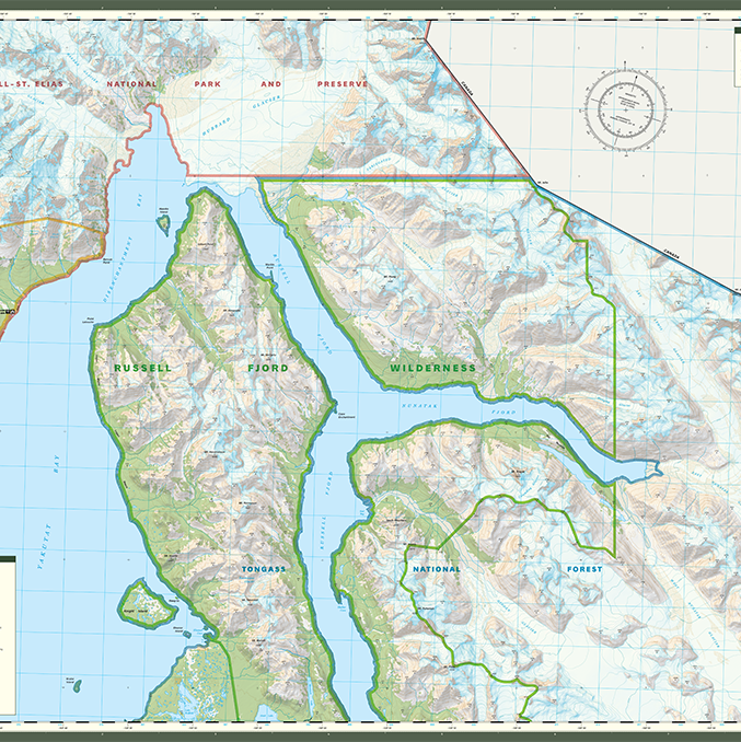
This outdoor map was created by Aaron Taveras of Russell Fjord Wilderness. It shows off the area's beautiful glaciers, majestic forests, and rocky moraines while providing helpful topographic details and recreational points of interest. avenza.com/map-gallery/ru…
Attending AGU and interested in #Landsat? Check out nearly 450 presentations that talk about using Landsat products here: ow.ly/KxBm50QhzHO!

Trends for United States
You might like