USGS Landsat @USGSLandsat
Official USGS account for the Landsat Program - a series of Earth-observing satellites co-managed by @USGS & @NASA. Imaging the Earth since 1972.📡🛰️ usgs.gov/landsat Sioux Falls, South Dakota Joined September 2009-
Tweets10K
-
Followers37K
-
Following214
-
Likes7K
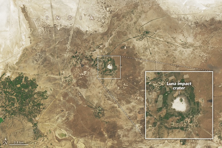
In northwest India, a circular feature has attracted curiosity in recent decades. A geochemical analysis of the area revealed it contains the characteristic signatures of a meteorite impact. #Landsat 8 captured an image of the Luna impact crater. go.nasa.gov/3UrWHnJ
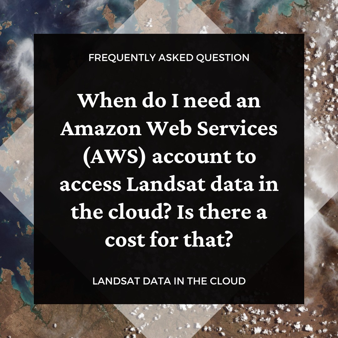
Landsat data are available to download at no charge through traditional USGS tools such as EarthExplorer. An Amazon Web Services (AWS) account is required if you prefer to access the data in the cloud, however. Learn more with this FAQ answer: ow.ly/ij9a50Ro0cT.

Landsat satellites have been capturing images of the Earth's surface for 50+ years. Not only do they have scientific value, but they're also beautiful to look at (some even resemble famous works of #art). Browse them all ➡️ ow.ly/c1p450RlGTJ #EveryDayIsEarthDay #NASA
#EarthAsArt collections bridge the gap between science and art by transforming #EarthObservation data into captivating displays of our planet. Explore the stunning landscapes of #Brazil here: ow.ly/ugfF50QRi4B
Consider who you’ll nominate for the Pecora 2024 Awards! The deadline is coming soon. Any individual or group who has made significant contributions in satellite or aerial remote sensing of the Earth is eligible. Learn more: ow.ly/mTeF50Rmlcx

Ice anglers had an unusually short season this year in northern Minnesota. This new Image of the Week offers a Landsat look at the past 10 Februarys to see how 2024 treated Mille Lacs Lake much differently. Find a closer view of the lake’s ice roads here: ow.ly/wsr650Rnamy
NASA’s Harmonized #Landsat and Sentinel-2 (HLS) project combines data from both satellites to revolutionize earth observation. 🌏 Take a journey through the cutting-edge world of remote sensing and explore the future of monitoring Earth's health with HLS. go.nasa.gov/4aJokyt
The UAE received about 10 in of rain, causing major flooding. This video shows Landsat 8 and 9 images of before and after this event in land/water band combinations, making the water appear purple. Learn about different band combinations with Landsat data: ow.ly/X0Eo50Rmvrg
Happy #EarthDay! 🌎 Every day, #Landsat takes a #GlobalSelfie! 🛰️ These images of Earth help scientists track changes in land surfaces and water resources from 1972 to the present. Learn more about the Landsat program: landsat.gsfc.nasa.gov

LANDSAT. The longest continuously running Earth-observing satellite program offers unique views of Earth’s land each day. We celebrate our planet every day from the vantage point of 438 miles above the surface! Check out the Landsat Science Storymap: ow.ly/JxuV50RlpPQ.

Happy #EarthDay2024! This annual worldwide celebration serves as a time to honor our home planet and recognize the invaluable contributions of #Landsat and #EarthObservationData in supporting the #SustainableManagement of Earth’s #NaturalResources.

🌏🛰️ What does the future of #Earthobservation science look like? It's out of this world! With @USGSLandsat Next launching in 2030 and partnering with @NASA and @USGS, we're building the future of #EO science from ground stations to satellites, to processing and applying EO data.


For decades, #Landsat satellites have monitored the vast landscapes of #YellowstoneNationalPark to help officials monitor #EcosystemChange, #WildfireSeverity and #GeothermalActivity. Check out the Yellowstone Earthshot here: ow.ly/Ps8850Rk8yu
#OTD in 2008, the USGS announced intentions to open the Landsat archive and make Landsat data available for download at no charge. Former USGS Associate Director for Geography Barbara Ryan in 2018 met to talk about opening the Landsat Archive. Watch here: youtube.com/watch?v=Sb8QKZ….
Eyes on ice 🧊 A new EROS-supported project collects up to 42 extra Landsat images daily at the poles. LEAP uses the full capabilities of Landsats 8 & 9 to capture changes in ice extent, even during polar twilight. Read the story, then listen to a podcast: ow.ly/P5lT50RjWnK

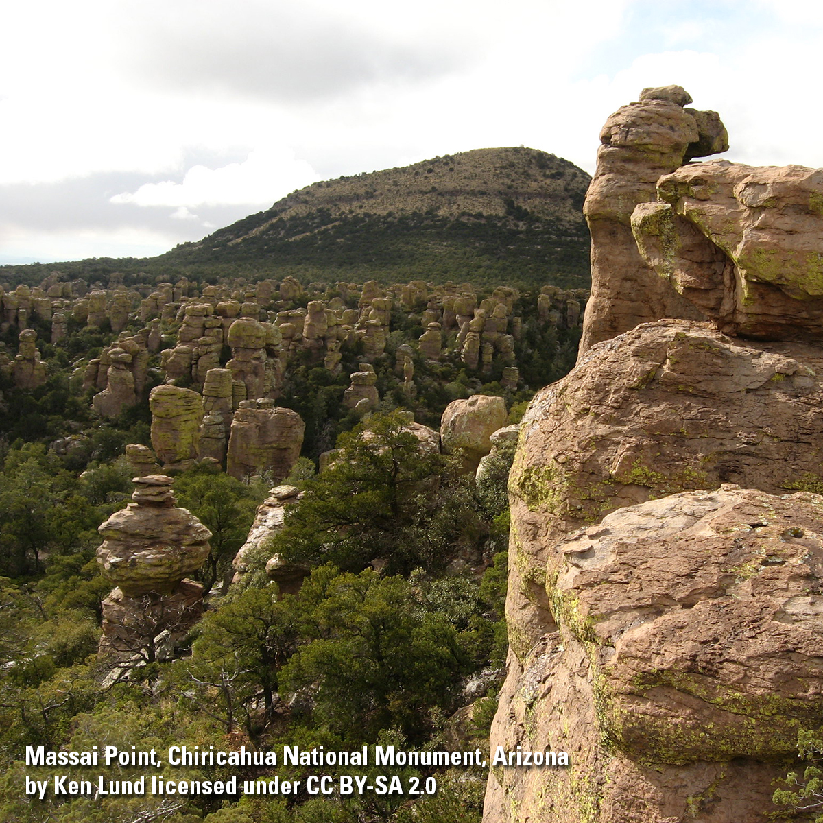
Celebrate a century of scenic wonder, cultural heritage and unique volcanic rock formations at #ChiricahuaNationalMonument. Established on April 18, 1924, the #WonderlandOfRocks is an extraordinary landscape located in the #ChiricahuaMountainRange of southeastern #Arizona.

The latest #RCMAP data release highlights updated projections of rangeland vegetation cover. These datasets will allow land and resource managers to assess the impacts of #ClimateChange on #RangelandEcosystems. Learn more here: ow.ly/yk8q50RipXp
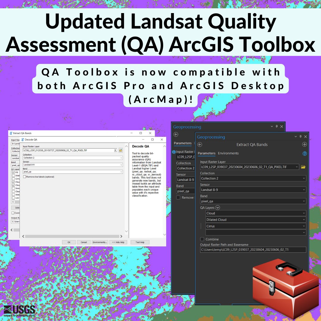
The Landsat Quality Assessment (QA) ArcGIS toolbox 🧰 has been updated! It now is compatible with ArcGIS Pro and now supports Level-3 Dynamic Surface Water Extent (DSWE) QA bands. Learn more about this toolbox and download it here: ow.ly/Nn3o50Rj8PL #Landsat #USGS #GIS
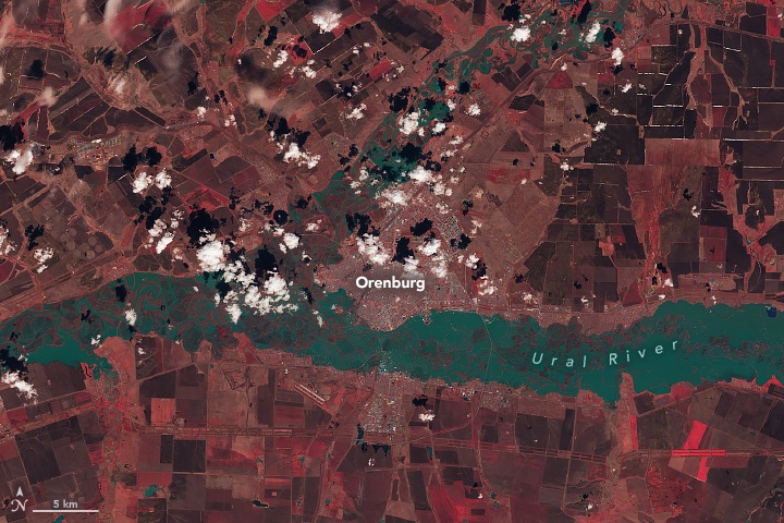
Rivers swelled in southern Russia & northern Kazakhstan in April 2024 following heavy rain & rapid snowmelt. These infrared-color #Landsat images show Orenburg, Russia on Apr. 5 (left), before flooding, & on Apr. 13 (right), the day river levels peaked. go.nasa.gov/4d1JXeL

Nominations are open for the Pecora 2024 Awards! Individuals or groups who have made contributions in the field of satellite or aerial remote sensing of the Earth’s surface are eligible. The deadline is May 15, 2024. Learn more: ow.ly/Kz7250Ri5mS.


Qiusheng Wu @giswqs
38K Followers 5K Following Associate Professor @UTKGeography | @Amazon Visiting Academic | Senior Reseach Fellow @UNUINWEH | #EarthEngine GDE | Talk about #opensource #geospatial #dataviz
NASA Landsat @NASA_Landsat
80K Followers 470 Following The NASA/USGS Landsat series of Earth-observing satellites has monitored our planet for 50 years. Verification: https://t.co/4p9BhINXeQ
ESA Earth Observation @ESA_EO
143K Followers 3K Following @esa #EarthObservation: Taking the pulse of our planet from space. Please see our Privacy Notice: https://t.co/zzMYcxj8xi
Remote Sensing MDPI @RemoteSens_MDPI
17K Followers 980 Following No. 1 #remotesensing #openaccess journal in Remote Sensing Category in #WoS, published by @MDPIOpenAccess; IF 2022 5.0; CiteScore 2021 7.9; #mdpiremotesensing
Mike Wulder @mikewulder
13K Followers 7K Following Senior Research Scientist with the Canadian Forest Service. 🍁 #Landsat super-fan. #Lidar. #Forests. #Remotesensing. 🌲🛰 Member of the #OrderOfCanada. 🎖
🥔🗺️ ᴘᴏᴋ.. @pokateo_maps
25K Followers 3K Following 👋🏻 I'm Kate ᵉᵃᵗᵉʳ ᵒᶠ ᵖᵒᵗᵃᵗᵒᵉˢ ᵃⁿᵈ ᵐᵃᵏᵉʳ ᵒᶠ ᵐᵃᵖˢ 🌐 I make #geospatial & #GIS (more) fun by sharing #mappymeme s & #maptastic themes. Hosts #GISchat. ᵛᶦᵉʷˢᵐᶦⁿᵉ
Keiko @Keiko_geo
11K Followers 4K Following PhD; VP of Science and Technology @climateengine; GDE @googledevs; #EarthObservation 🌳🌴🛰 #AI; #EarthEngine tips for #BetterFuture🌏; from 🗾; views my own
NASAEarthdata @NASAEarthData
40K Followers 417 Following Discover NASA Earth science data, information, services and tools. Have questions? [email protected] Verification: https://t.co/yvflidJq6x
USGS EROS @USGS_EROS
7K Followers 158 Following USGS Earth Resources Observation and Science Center. The changing face of your planet: documented, studied & shared since 1973. Questions: [email protected]
Pierre Markuse @Pierre_Markuse
10K Followers 2K Following Never stop being curious! #RemoteSensing #Sentinel #Landsat some #wx . Sat images on Flickr: https://t.co/429cDFeGh4
Dr Robbi Bishop-Taylo.. @SatelliteSci
8K Followers 6K Following Earth Observation Scientist at @GeoscienceAus. Using satellite data 🛰️ to study the earth 🌍 through space and time
Justin Braaten @jstnbraaten
7K Followers 2K Following DevRel for @google #EarthEngine Interested in #Conservation #Landsat #EO #TimeSeries #DataViz
Sisters of SAR @SistersofSAR
10K Followers 4K Following A passion for all things #SAR | #WomeninSAR | @eoscenefrom | We 💜@LadiesofLandsat & @DamesofDrones| Tweets by @LDR1, @SAR_ahBanks, @Go__Pika & @ant_dasgupta |
Joshua Stevens @jscarto
15K Followers 1K Following Cartographic Editor @mapsdotcom & Content Strategy @Esri. Prev: DataViz Lead @NASAEarth, @NSF PhD Fellow @PSUGeography. Dad stuff everywhere else. Views my own.
Sentinel Hub @sentinel_hub
39K Followers 472 Following A geospatial developer platform for EO data. Now a part of @Planet.
Zhe Zhu 🌎🛰️ @GERSLab
4K Followers 1K Following Associate Professor @UConnNRE, Director of Global Environmental Remote Sensing Laboratory, USGS-NASA Landsat Science Team, Associate Editors of RSE, SRS, & JRS.
Ladies of Landsat @LadiesOfLandsat
12K Followers 5K Following ALL are welcome! | #STEMinism | We 💜 @SistersofSAR, @WomenofWaves & @DamesofDrones! | Website coming soon!
Mustafa Ustuner @mustuner2
4K Followers 5K Following Assist. Prof @ArtvinCoruhUnv | Alumni @YildizEdu @tcktu1955 | Former visiting scholar @usfsp @unijena | Member @ieee_grss @isprs |📍Artvin & Bafra 🇹🇷
Copernicus EMS @CopernicusEMS
68K Followers 2K Following Copernicus Emergency Management Service provides mapping products based on satellite imagery as well as #ForestFires #Flood and #Drought early warning products.
Esri @Esri
193K Followers 70K Following Esri builds #ArcGIS, the leading location intelligence and spatial analytics software for mapping, 3D GIS, imagery, and geospatial app development.

Idris Muhammad Kabir @imkabir487
0 Followers 37 Following Civil Engineer with Geographical Information System and Remote Sensing Background
basil debs @DebsBasil23168
1 Followers 85 Following
Reginald @SherylS10103
0 Followers 96 Following
Al @gudaleon
221 Followers 1K Following
CHILL_RGO @CHillRGO
0 Followers 31 Following
Ishigami Senku @Ishigamisenku41
21 Followers 202 Following

GK @kimguan18
57 Followers 883 Following
Samuel Pavlovkin @SPavlovkin
1 Followers 53 Following

Kelly Bruno @BKyouRul
1 Followers 20 Following
HUA Earth Observation.. @huaeoteam
4 Followers 54 Following •Research team specialized in Remote Sensing applications 🛰️ •Department of Geography, Harokopio University of Athens 🌍

MMF Digital Hub @HubMmf
9 Followers 160 Following Crypto Earner, Trainer, Traveler, Reader, IT Enthusiast
Mary Taylor @mary_taylo72965
0 Followers 5 Following
Graham Bells @GrahamBell82
148 Followers 848 Following

Muchammad Fikri Arvia.. @fikriarvian
8 Followers 122 Following Grandfather Uyoh Rachmatulloh 09 Novembre 1926 - 16 July 2004 in Asia Pacific Greenwich Mean Time +7

danny @GeNiO426
1K Followers 913 Following Co-Founder of @theworldsempire. NJ. Be Great, Help Others. Learn from the past. Plan for the future. Live in the present.
COASTAL CRETE @Coastal_Crete
52 Followers 196 Following A high-resolution coastal forecasting system for CRETE Island
Luna Ma @LinMa64126
2 Followers 58 Following
LionKing2030 @SaudiLion2030
131 Followers 3K Following G7 Technology Artificial Intelligence Smart Cities Innovations and Patents Space NASA Environment Planet Earth Health English Premier League
Tony Feng @Tony_Feng_UMD
11 Followers 20 Following PhD student at UMD_GEOG. Lidar, Landsat, Forest, Fire, Carbon.
InnovateX Hub @InnovateXHub
8 Followers 186 Following InnovateX Hub is a driven Rwandan - based Company that aims to empower a sustainable tomorrow through geospatial excellence.
Imran Ahmad Siddiqui @ImranAhSiddiqui
16 Followers 170 Following
Emmanuel Ruina @EmmanuelRu1264
0 Followers 11 Following

Joey Manteiga @ArctictheDragon
59 Followers 472 Following I am a very humorous, sarcastic, and friendly person. I like video games. Mostly RPGs like Fallout Series and Elder Scrolls. I am a furry.
Vivek Singh Kshatriya.. @I_viveksingh_
214 Followers 3K Following #Mahadev 🌐🔱🎀. #PoliticallyMonitoring🌲. #AllCenturyLink☀️. #KedarnathDevelopingDreams 🇮🇳. [email protected], WhatsApp-8797265010 , 8797885010.
吃口白日梦 @GISer_chaohuo
1 Followers 101 Following
Jonas @JonasAKBM
39 Followers 223 Following
Renuka Shastri @renukashastri9
3 Followers 35 Following
Spiros Evangelou @SpirosEvangelou
225 Followers 758 Following Professor. For more than a decade I was giving lectures on Quantum Information theory. Among many others. All lectures were addressed to University students.
Chathumal Weththasing.. @Chathumal93
36 Followers 212 Following Geospatial analyst passionate about using data and technology to tackle pressing environmental issues.
문영란 @_yrmoon
0 Followers 65 Following
ALABSEE @alabsee5
68 Followers 379 Following (إِنَّ الَّذِينَ يُحَادُّونَ اللَّهَ وَرَسُولَهُ أُوْلَبِكَ فِي الْأَذَلِّينَ كَتَبَ اللَّهُ لَأَغْلِبَنَّ أَنَا وَرُسُلِى إِنَّ اللَّهَ قَوِيٌّ عَزِيزٌ)
Utsav Biswas @Utsav_Biswas_
0 Followers 362 Following


Ramiro Alejandro Ferr.. @ferrau_ramiro
87 Followers 479 Following Estudiante de Ciencias Geológicas. Interés en SIG, Sensores Remotos, Geomorfología e Hidrogeología.
B. S. Bison @bigsonbison
2 Followers 81 Following I am a Christian that loves God, the USA, soccer (Up the Toffees), geology, and GIS—among other things.
Koichi Sugimoto @KoSu05772991
5 Followers 116 Following I love mountaineering and earth science,such as weather,earthquake,volcano,ocean and so on.
adel @Adel744Adel
31 Followers 402 Following
El Memo de Mileto @JorgeGu07002235
74 Followers 374 Following
Ngirinshuti @NgirJustin
36 Followers 253 Following
Moses Kioko @kioko_genius
212 Followers 2K Following Data analyst acquainted with skills in Designing Data Collection tools(surveyCTO,ODK,CommCare), Data Analysis(R, Python,STATA, SPSS, Ms Excel) and an M&E Expert

Pasquale Mezzanotte A.. @PasqualeMe66805
807 Followers 8K Following
NASA Landsat @NASA_Landsat
80K Followers 470 Following The NASA/USGS Landsat series of Earth-observing satellites has monitored our planet for 50 years. Verification: https://t.co/4p9BhINXeQ
ESA Earth Observation @ESA_EO
143K Followers 3K Following @esa #EarthObservation: Taking the pulse of our planet from space. Please see our Privacy Notice: https://t.co/zzMYcxj8xi
NASAEarthdata @NASAEarthData
40K Followers 417 Following Discover NASA Earth science data, information, services and tools. Have questions? [email protected] Verification: https://t.co/yvflidJq6x
USGS EROS @USGS_EROS
7K Followers 158 Following USGS Earth Resources Observation and Science Center. The changing face of your planet: documented, studied & shared since 1973. Questions: [email protected]
Sentinel Hub @sentinel_hub
39K Followers 472 Following A geospatial developer platform for EO data. Now a part of @Planet.
Ladies of Landsat @LadiesOfLandsat
12K Followers 5K Following ALL are welcome! | #STEMinism | We 💜 @SistersofSAR, @WomenofWaves & @DamesofDrones! | Website coming soon!
Copernicus EMS @CopernicusEMS
68K Followers 2K Following Copernicus Emergency Management Service provides mapping products based on satellite imagery as well as #ForestFires #Flood and #Drought early warning products.
Esri @Esri
193K Followers 70K Following Esri builds #ArcGIS, the leading location intelligence and spatial analytics software for mapping, 3D GIS, imagery, and geospatial app development.
USGS Data Science @USGS_DataSci
11K Followers 184 Following Featuring @USGS #dataScience and #DataViz
EUMETSAT @eumetsat
42K Followers 2K Following European Organisation for the Exploitation of Meteorological Satellites. Observing weather and climate from space since 1986. Monitored Mon-Fri 09:00-18:00 CET.
USGS Water Resources @USGS_Water
7K Followers 58 Following Observing, understanding, predicting, delivering #WaterScience 💧Comment policy: https://t.co/fdMZuJnkZx 💧Posts do not=endorsements https://t.co/SEG5ZFX36x
Esri Training @EsriTraining
33K Followers 1K Following Advancing geospatial capabilities of individuals, teams, and organizations is our mission and our passion.
NASAARSET 🛰🌎 @NASAARSET
15K Followers 333 Following NASA's Applied Remote Sensing Training (ARSET) program empowers the global community through remote sensing training. Verification: https://t.co/wDGYeUYaMM
Digital Earth Africa @DEarthAfrica
7K Followers 264 Following #DigitalEarthAfrica translates satellite data into easy to consume information for the entire African continent.
USGS National Uncrewe.. @USGS_UAS
1K Followers 218 Following USGS National Uncrewed Systems Office. We help researchers use uncrewed aircraft systems (#UAS, #drones) to support @USGS science. Tweets do not = endorsement.
EO OPEN SCIENCE @EO_OPEN_SCIENCE
15K Followers 854 Following European Space Agency account for the #EarthObservation (EO) #OpenScience user community. Exploring challenges & opportunities created by revolutions in #EO.
USGS in Idaho @USGS_Idaho
7K Followers 224 Following The U.S. Geological Survey provides reliable, unbiased scientific information in the areas of ecosystems, energy and minerals, natural hazards, and water.
GEDI @GEDI_Knights
6K Followers 47 Following NASA/UMD's Global Ecosystem Dynamics Investigation is a lidar mission on the ISS mapping forest structure. Account managed by UMD. May the forest be with you.
NASA Exhibit @NASAExhibit
19K Followers 178 Following Explore the universe and our home planet with @NASA virtual exhibits, live events, online activities and more! 🚀🤓🤩👩🏾🚀
NASA Solar System @NASASolarSystem
2.9M Followers 148 Following We are NASA's Planetary Science Division. Ride along with us as we explore the worlds of our solar system.
Canadian Space Agency @csa_asc
378K Followers 1K Following The Canadian Space Agency coordinates all civil, space-related programs on behalf of the Government of Canada. Terms: https://t.co/58Nfe1GL0V (Français @asc_csa)
The GLOBE Program @GLOBEProgram
11K Followers 186 Following GLOBE connects students, teachers, scientists, and the public from around the world to better understand the Earth. @NASA @NSF @NOAA and U.S. State Dept.
USGS HDDS @USGS_HDDS
2K Followers 29 Following Hazards Data Distribution System (HDDS) provides access to aerial and satellite imagery for emergency response. Tweets do not =endorsement: http://t.co/C8LLxqxS
Tanya Trujillo @AsstSecTrujillo
2K Followers 174 Following This is an archived account and is not being updated. Proud to have served @SecDebHaaland as Assistant Secretary for Water and Science of @Interior 2021–2023.
USGS MD-DE-DC @USGS_MD_DE_DC
1K Followers 73 Following Sharing #WaterScience from the USGS Maryland-Delaware-DC Water Science Center. Tweets ≠ endorsement. https://t.co/DbiR9GvPKi
NASA Atmosphere @NASAAtmosphere
431K Followers 120 Following NASA studies the atmospheres of our planet and others to better understand weather and climate on Earth – and beyond. Verification: https://t.co/RFkwCpUIHa
USGS Kansas @USGS_KS
2K Followers 125 Following Science for a changing Kansas. Tweets do not = endorsement
CentroGeo @CentroGeo_
4K Followers 2K Following Centro Público de Investigación integrado al sistema CONAHCYT.
OpenET @openetdata
708 Followers 322 Following Filling the Biggest Data Gap in Water Management Learn more at https://t.co/tSHKMry4kw
National Weather Serv.. @NWS
3.1M Followers 328 Following Official Twitter account for @NOAA's National Weather Service. A list of official NWS accounts can be found at https://t.co/x5itrXGTJT

Vandenberg Space Forc.. @SLDelta30
23K Followers 143 Following Official account of Space Launch Delta 30. Creating the "Range of the Future". Ensuring space superiority. Safely delivering payloads into polar orbit.
ULA @ulalaunch
367K Followers 1K Following The nation’s most experienced, reliable and accurate launch service provider.
UtahView @UTView
56 Followers 62 Following
USGS Climate @usgs_climate
3K Followers 165 Following Stories about how climate change affects wild places & communities and the science that’s helping them adapt. Comment policy: https://t.co/jHEr3gg3p1.
Women in Copernicus @WomenCopernicus
3K Followers 2K Following #WomeninCopernicus - A European action to identify & give a voice to the women working on 🇪🇺 #Copernicus #EarthObservation #space 📺 https://t.co/WMOOlfTp3e
Copernicus Land Monit.. @CopernicusLand
12K Followers 796 Following Copernicus is the European Union's Earth Observation programme. CopernicusLand is one of six thematic services that deliver free and open geospatial products
GEOGLAM @G20_GEOGLAM
3K Followers 387 Following GEO Global Agricultural Monitoring - Launched by G20 in 2011 - Strengthening #agriculture & #foodsecurity thru free & open #EO #ZeroHunger
Cubo de Datos Geoespa.. @CuboDeDatosMX
128 Followers 152 Following Noticias y actualizaciones sobre el Cubo de Datos Geoespaciales de México. ¡Crezcamos la comunidad de usuarios!
Land-Cover & Land-Use.. @LCLUCProgram
1K Followers 371 Following NASA Land-Cover and Land-Use Change (LCLUC) Progrm is an interdisciplinary science program in the Earth Science Division of the Science Mission Directorate.
Secretary Deb Haaland @SecDebHaaland
164K Followers 63 Following 54th Secretary of @Interior, proud member - Pueblo of Laguna, 35th generation New Mexican. Working to preserve our public lands for future generations. She/Her
Instituto Geográfico.. @IGNSpain
47K Followers 1K Following Cuenta oficial del IGN, organismo oficial del @transportesgob que genera la información geográfica de España y la distribuye a través de: https://t.co/cvGOemPj7A
NASAOcean @NASAOcean
10K Followers 97 Following We are a group of innovators working on sustainable solutions to support our planet’s largest ecosystem: the ocean. Verification: https://t.co/hdgP5Nu8RK

Women+ in Geospatial @geospatialwomen
10K Followers 305 Following An inclusive and global community that inspires, unites and empowers women+ in the geospatial field to become strong leaders and changemakers! Join us👇today!
Department of the Int.. @DOIPressSec45
3K Followers 505 Following @Interior Press Office from '17-'21. Proudly served the American people, @realDonaldTrump, @SecBernhardt and @SecretaryZinke. Tweets are archived.
Women@NASA @WomenNASA
144K Followers 135 Following Sharing the perspectives, stories, & accomplishments of the incredible women who are making history at NASA every day. Verification: https://t.co/kN8B2A5XsZ
NASA Ames @NASAAmes
462K Followers 122 Following We're NASA's center in Silicon Valley. Verification: https://t.co/SdAqRzd1mQ
USGS Science in NJ @USGS_NJ
934 Followers 59 Following Follow USGS New Jersey for information on USGS science activities in the Garden State and beyond. Tweets do not = endorsement
AmeriGEO @AmeriGEO
866 Followers 84 Following AmeriGEO a framework to promote EO collaboration and coordination among the GEO members in the American continent.
GEO Mountains @GEO_Mountains
1K Followers 1K Following Global Network for Observations & Information in Mountain Environments, co-led by @MtnResearchMRI & @CnrIsac & part of @GEOSEC2025 work programme. #EO4Mountains
Harvest @HarvestProgram
7K Followers 2K Following @NASA's Global Food Security & Agriculture Consortium est. 2017 Earth Data for Informed Ag Decisions (Tweets our own, for official NASA comms visit @NASAEarth)
Commission for Enviro.. @CECweb
8K Followers 4K Following Three countries working together to protect our shared environment in #NorthAmerica 🇨🇦🇲🇽🇺🇸 Follow us en français: @CCE_Francais y en español: @CCA_Espanol
USGS_YES @USGS_YES
969 Followers 161 Following USGS Youth & Education in Science (YES). Tweets do not = endorsement: https://t.co/uNq2sioiCU (Contact: https://t.co/aQu4AO8aY9)
ESA Climate Office @esaclimate
12K Followers 476 Following European Space Agency's Climate Office, often tweeting about ESA's Climate Change Initiative programme
Cornell Lab @CornellBirds
109K Followers 395 Following A world leader in the study, appreciation, and conservation of birds and biodiversity. | We’ve been “tweeting” since 1915. | Try our free @MerlinBirdID app.
geosociety @geosociety
68K Followers 962 Following The Geological Society of America (GSA) unites earth scientists and facilitates the sharing of scientific findings about our planet and universe.
Northrop Grumman @northropgrumman
303K Followers 684 Following We solve the toughest problems in space, aeronautics, defense and cyberspace. Follow our official accounts: @northropgrumman @NGCNews @NG_Careers
The Nature Conservanc.. @nature_org
977K Followers 9K Following Our mission is to conserve the lands and waters on which all life depends. Working in 79 countries and territories, all 50 U.S. states and your backyard.Trends for United States
You might like