SuperMap @SuperMap__GIS
GIS platform software and solution provider. Innovate Geospatial Intelligence, Elevate IT Value. #GIS #3DGIS #BigDataGIS #AIGIS #BIMGIS supermap.com/en-us/ Global Joined April 2009-
Tweets2K
-
Followers7K
-
Following5K
-
Likes2K
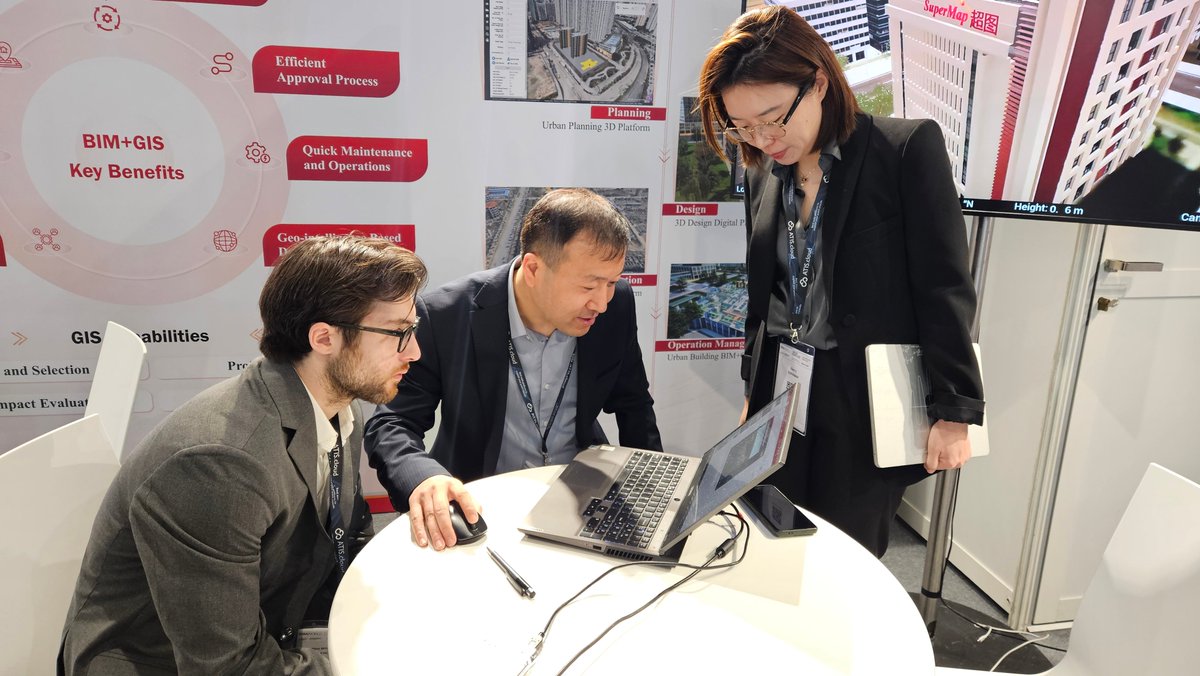
The #GeoExhibition in Japan is now in full swing! We’ve delivered a speech to introduce #SuperMap. What is CIM View 2024? Come to stand 25 on the venue and check it out! bit.ly/3JqjCJR About CIM View 2024: bit.ly/3JqQja2 Follow us for more news!

The #GeoExhibition in Japan is now in full swing! We’ve delivered a speech to introduce #SuperMap. What is CIM View 2024? Come to stand 25 on the venue and check it out! bit.ly/3JqjCJR About CIM View 2024: bit.ly/3JqQja2 Follow us for more news!

GIS is an important means to achieve rational planning and utilization of land, and #mobileGIS is flexible and convenient to use. SuperMap integrates mobile GIS into #landplanning and utilization business, solving various management problems. Check it out: bit.ly/3vQgp39


🎉🎉SuperMap will be present at the Geo Exhibition in Japan on 19th April. We’ll demonstrate SuperMap’s #GIS platform software and achievements in #AI, #CIM, and other advanced fields. Welcome to visit us at stand 25!👋 About SuperMap Japan: supermap.jp
🎉🎉SuperMap will be present at the Geo Exhibition in Japan on 19th April. We’ll demonstrate SuperMap’s #GIS platform software and achievements in #AI, #CIM, and other advanced fields. Welcome to visit us at stand 25!👋 About SuperMap Japan: supermap.jp


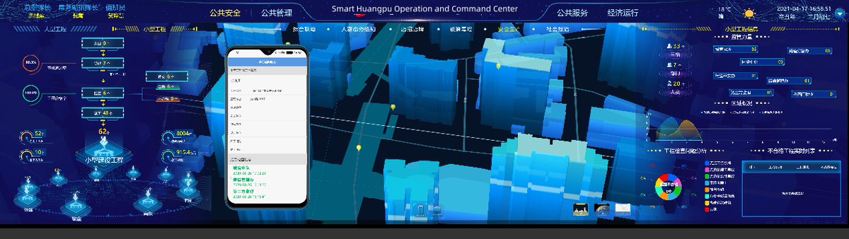
The Huangpu District is an old area with many old buildings in #Shanghai, China. To advance digital management, the local authorities built a comprehensive operation and command platform together with SuperMap and other companies. Take a look: bit.ly/495pGlf #BigData #AI


Hi guys! The new round of #SuperMap #GISContest has started! It is open to global college and university students who can use SuperMap technology to present innovative projects with unique GIS vision. Come and show us your talent! Bonuses await you! bit.ly/3LZu9ML

Ladies, you are not the leading role only today. You are strong, powerful and resilient. Be the one you want to be. Happy International Women’s Day! #women #womenspower #sheherhers

Video GIS map is based on video spatialization. Combined with drones (#UAV), video GIS can be applied to various scenarios where it is not suitable for manual work such as forests, polluted areas, or urgent situations. #videogis #Drone #emergencyresponse #naturalresources


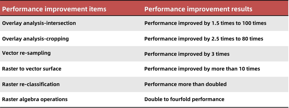
The new version of SuperMap #cloudGIS products have below improvements: 📷High-concurrency dynamic drawing performance; 📷Query and rendering performance optimization based on FlatGeobuf technology; 📷Updated serverless functions …and more. Learn more: bit.ly/3UXk8WB


#SuperMap iMobile is a high-performance, cross-platform professional mobile #GIS software development platform. It has been upgraded in terms of map display and browsing, #AR map application, dynamic plotting and deduction, and etc. Learn more: bit.ly/3SQmzHO #mobilegis


If you have the needs to manage and fast release massive images, welcome to use SuperMap iServer, it's a server platform that integrates multiple image processing services. Learn more: bit.ly/3wnNSlg #remotesensing #satelliteimages #datamanagement #SuperMap

To better mine the value of BIM data, SuperMap CIM platform adopts BIM+GIS technology, achieving breakthroughs in key technologies such as lossless access to BIM mainstream data, seamless connection between BIM data and 3D models. For more detailes: bit.ly/3HRQ72G


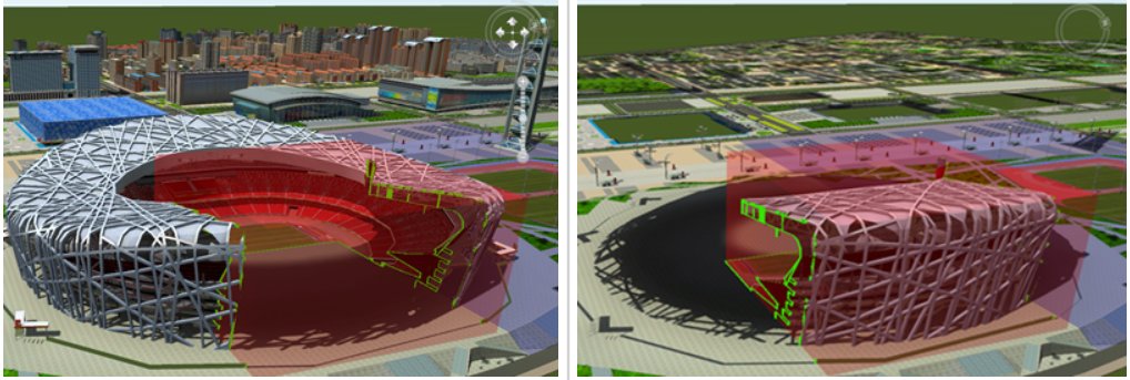

#CIM Platform, with the development and building of digital twin, has become a fundamental information infrastructure of #smartcities. #BIM, thanks to its advantages like more refined and accurate model data, is an important data source for CIM platform.
🎇For many people in the world, especially those in Asia, the lunar new year is just around corner. SuperMap prepared a firework show at the “Digital Shenzhen Bay”. Come and celebrate the new year with us! #Digitaltwin #Shenzhenbay #SuperMap #newyear #fireworkshow
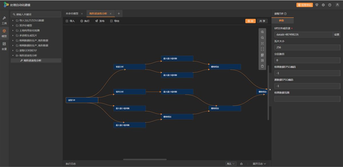
Need helpful tools to help you with data processing? SuperMap iServer Processing Automation should be your go-to tool. bit.ly/42khXOt #automation #automatedprocessing #data #SuperMap
The discussion about the integration of drone video, #GIS and #AI isn’t over yet. We’ve introduced how video can be integrated with GIS data, let’s continue to exploration the value of AI empowering #UAV videos and its applications. Click for full article: bit.ly/3u7q8B6


#UAVs are trending. Thanks to multiple advantages, they are useful tools in #surveying and #mapping industry. What if we combine UAVs with #GIS? With #AI? What kind of things they can do together and what value they can bring to us? Check it out: bit.ly/3HvXlJx #drone


Qiusheng Wu @giswqs
38K Followers 5K Following Associate Professor @UTKGeography | @Amazon Visiting Academic | Senior Reseach Fellow @UNUINWEH | #EarthEngine GDE | Talk about #opensource #geospatial #dataviz
🥔🗺️ ᴘᴏᴋ.. @pokateo_maps
25K Followers 3K Following 👋🏻 I'm Kate ᵉᵃᵗᵉʳ ᵒᶠ ᵖᵒᵗᵃᵗᵒᵉˢ ᵃⁿᵈ ᵐᵃᵏᵉʳ ᵒᶠ ᵐᵃᵖˢ 🌐 I make #geospatial & #GIS (more) fun by sharing #mappymeme s & #maptastic themes. Hosts #GISchat. ᵛᶦᵉʷˢᵐᶦⁿᵉ

Matt Malone @MatthewHMalone
7K Followers 598 Following GIS Professional/GIS meme aficionado | Geography, geology and weather geek | 🐘 https://t.co/tZmoBPjeig; 🦋https://t.co/7nMrtkx5sH
Humanitarian OpenStre.. @hotosm
29K Followers 3K Following 🗺️ Global Humanitarian OpenStreetMap Team. #OSM for humanitarian response and community-led development.
arnalie @arnalielsewhere
3K Followers 2K Following The best map of the world should be the best & inclusive space for all 🗺 | board @openstreetmap | online community @hotosm | agitator for DEI | views mine 🌈
Frida Mwangi @FridaMwangi1
5K Followers 2K Following Survey|| Numbers|| World|| Lands||Construction Chair-Young Surveyors Committee- The Institution of Surveyors of Kenya
Feye Andal @dfeyeandal
2K Followers 536 Following WebGIS, @upresilience | Educator, @DLSUManila | Co-founder, @upriyouth | Regional Ambassador, @youthmappers | Voting Mem, @hotosm | Assoc Mem, @openstreetmap
Charlie Verdel @CSVerdel
3K Followers 5K Following Geologist in central Australia. 🇺🇸 in 🇦🇺 https://t.co/fvuMPMPayp
Geography with Justin @GeoWithJustin
2K Followers 385 Following Geospatial Professional 🗺Cartography, Python🐍🌐🛰 Remote Sensing and Earth Observation 🌎🌍🌏 BS Geog @ASU_SGSUP • MGIST @NCSUgeospatial 🗣️EN/ES/IT • Married
Whitebox Geospatial @whiteboxgeo
7K Followers 2K Following Innovative geospatial software solutions built on open-source. #lidar #TerrainAnalysis #geospatial #GIS #remotesensing #geomorphometry #geomatics
Africa's Exciting Net.. @GISforAfrica
4K Followers 1K Following Building a better Africa for all through our community members, courses, events, investment plans, resource centres, geospecial consultancy, goods,and services.
Spatial Trouble Maker.. @Todd_Effin_Barr
10K Followers 7K Following Queer/ENBY AF 🏳️🌈🏳️⚧️ I work in the Natural Disaster/Climate/ESG Space, figuring out where Geospatial helps solve the puzzle. Unapologetic Ke$ha Fan
Nicholas Mutethia Kar.. @mutethia_karuma
3K Followers 3K Following Geospatial Engineer, RPL, GIS & Engineering Survey, Technical University of Kenya, AutoCAD Civil 3D, Carlson Survey, DJI Terra, Lidar 360, Matrice 350.
Greg Cocks 🇺🇦 @gregcocks_kiwi
2K Followers 3K Following Personal Account, All Views My Own | Spatial Data Scientist/Researcher | #spatial #GIS #water #hydrology #AllDataIsSpatial #KiwiInColorado #DataIsTheNewBacon
AFRO🌍TECH💻 #Geo.. @_francisodero_
3K Followers 2K Following @wemappers | Ecoscope Engineer @MaraElephant | GIS Software Developer | Google Earth Engine | #Python #GeoDjango GitHub - https://t.co/xNEVeTHhit
Missing Maps @TheMissingMaps
19K Followers 4K Following A humanitarian project that maps areas to meet the needs of vulnerable communities. An open collaboration building on #OpenStreetMap Join us!
Daniel B. 🔅 𝘛�.. @DOh_Bams
3K Followers 1K Following Geospatial Data Analyst | Data Scientist | R Shiny Developer #R #ArcGIS #QGIS #Excel #SQL #python https://t.co/ZgZNOjfjNA
TheGeoSpatialHub @TheGeoSpatialH1
629 Followers 16 Following A space for aspiring and established geo-professionals to grow and connect. Our vision is to create a nurturing community for geo-professionals.
Mary Muthee @_marymuthee
2K Followers 305 Following GIS mapper on a mission... Tweeting: #gis #geospatial #programming #RemoteSensing #maps ....2022/2023 @gssa_tuk chairperson .
Nathaniel @Nathaniel142610
2 Followers 103 Following
Aeshah Fallatah @AeshahFallatah
2 Followers 26 Following
Stete @Stete1116962
29 Followers 2K Following
Valère SOKENG @jofvalre
44 Followers 839 Following Dr Valère SOKENG est chercheur au CURAT de l'UFHB et expert E-learning à l'UVCI
Kuratu Kushuma @KuratuKushuma
18 Followers 92 Following kuratu kushuma Gamo Zone Arba minch Ethiopia Geologist
Leticia Burone @LeticiaBurone
209 Followers 1K Following Docente, investigadora Ciencia y Tecnología Marina (Cincytema). Apuesto a la invención de nuevos conceptos e ideas para generar nuevos caminos de percepción!

ニュートン🎓 @mut7m_abdeen
207 Followers 1K Following def result() : if happiness and money != 100m$ : result(desperate life)
Derek Law @GIS_Bandit
6K Followers 1K Following Product Manager @Esri | Interests #GIS, #HealthGIS, #Maps, #DataViz Bluesky: https://t.co/wQd6s7i22E Comments are my own.

Mr.Z @MrZ33737715
58 Followers 811 Following
مجيد ملوك ا�.. @MjydMlwk91545
112 Followers 465 Following جغرافي/كاتب،مؤلف،أستاذ جامعي. دكتوراة1996جامعة بغداد، الأستاذية2004 professor.ألف ونشر ورقيا وإلكترونيا195كتابا وبحثا علميا.
Carter Parcel @carter_par31650
81 Followers 1K Following auto cad, topography survey,lidar 360,DJI terra,Matric 350,Madirelo technically college ☺️
ljwvictoria @lijiawei2017
0 Followers 14 Following
blackdarkxxx46 @blackdarkx22294
0 Followers 9 Following
porqué se quieren me.. @MARKPENAFLORIDA
486 Followers 3K Following

LyricLoom @lyric8981
22 Followers 2K Following
Diego Villafuerte @diego_esteban_v
133 Followers 172 Following Ingeniero Geógrafo y del Medio Ambiente Emprendedor, volcado a los negocios digitales, en una búsqueda constante de mejorar y ayudar a mejorar
Mahmoud Noaman AL Naj.. @mahnoaman
22 Followers 299 Following GIS Consultant @GIS-Center, Holy Makkah Municipality,
Janet @Yatteruf
1K Followers 5K Following "Dude she just called you irresponsible!" "Oh hell no.. Hold my steering wheel!"
@ComradeUyoata (Decen.. @comradeuyoata
442 Followers 753 Following Counsellor | Educationist | Arsenal Fans | Community Mobilizer |

お豆〜マイノリ.. @drsg08210807
298 Followers 204 Following ’23年6月✈ ドゥマゲテ移住しました🇵🇭 家庭内平和はビールにかかってる。 英語教育に重きはおかず、逞しく生きる力を。 行動派なママです。 フィリピン人と初めての交流は学生時代のバイト、ニューハーフパブ。 みんな違ってどうでもいい。 👦🏻34👩🏻34👧🏻6👦🏻4
ALABI BABATUNDE @Akande_bab
39 Followers 223 Following Easy going, humble,straightforward and I believe that whatever belong to me will certainly come my way!

Samuel Kimani @skimani412
763 Followers 2K Following GIS and Remote Sensing Enthusiast, ESIA/EA ; #Books #Music #Nature #GodAboveAll
Ayomide Temi @TemiAyomid15817
2 Followers 112 Following
Dingfan Xing @XingDingfan
116 Followers 204 Following PhD, Small Area Estimation, Applied Statistics, Sampling, Remote Sensing, GIS
EUthMappers @EUthMappers
36 Followers 75 Following EUthmappers aims to enhance STEM knowledge in secondary schools by training teachers and students in data processing and stimulating civic and environmental eng
GEONEX @GEONEXAnalysis
13 Followers 32 Following Welcome to GEONEX, where art meets intelligence in the realm of geospatial analysis and open-source intelligence (OSINT).
Masher @_roymunga
59 Followers 241 Following Land Administrator | GIS Programmer | Land Surveyor | Mapper
youthmappers Umsa - B.. @YouthmappeUMSA
8 Followers 149 Following First official Chapter of Youthmappers in Bolivia 🇧🇴 Youthmappers UMSA- Bolivia #Geography #Mapping #GIS #Spatialdata #EarthObservation #Science
Clifford Okembo @Cliffordboston
1K Followers 795 Following Geospatial & Land Admin consultant, Geotechnical evangelist, GIS lecturer, former CEO @EsriEA, an Adventist, Father, Leader, coach and advisor.

Surv mwagadijm @Mwagadijm
188 Followers 314 Following Land surveyor If we rise, We rise with honour . If we fall, It must be so.
Hossein @HosseinHmwe98
46 Followers 239 Following

Ahmed Al Fazari @ah94fazari
531 Followers 2K Following |SQU-GIS|The future belongs to those who believe in the beauty of their dreams.
luozekun @luozekun1
0 Followers 26 Following
jose mosquera @joseismaelmosq2
27 Followers 5K Following Constructor en arquitectura e ingenieria-universidad santotomas, sociólogo- udea, magister en psicoanálisis-udea
Boitreuben @Boitreuben
139 Followers 449 Following
Joe McCann @Joebocop
395 Followers 2K Following Mineral exploration, GIS, T1D, and Toronto Maple Leafs. Mostly looking for answers to a growing number of perplexities.
Mathoo Chumbaa @MathooC59730
3 Followers 45 Following
Nebula93 @Nebula931
39 Followers 251 Following Space/ music/ mapping nerd with a penchant for PC gaming, KC Chiefs and BBQ....
Fernando Vazquez R. @Ferdinand_VR
74 Followers 465 Following Ingeniero geólogo (el de las piedritas 👷🏼♂️⛰️⚒️🇲🇽), buceador certificado (PADI 🌊🤿), idiomas 🗣️: 🇬🇧🇫🇷🇮🇹
Ana Manzanares @anamanvil_
6 Followers 44 Following
AMOUZOU bernard @amouzou_bernard
70 Followers 327 Following Géographe, Cartographe/ @OsmTogo/@JVE_Int /@YED/ @Qgis/ #SIG/ #Opendata/ Data collection specialist at @MitsioMotu

Mary Muthoni Muriuki,.. @muthonikenya
18K Followers 9K Following Principal Secretary (PS) for Public Health and Professional Standards in the Ministry of Health Kenya
Qiusheng Wu @giswqs
38K Followers 5K Following Associate Professor @UTKGeography | @Amazon Visiting Academic | Senior Reseach Fellow @UNUINWEH | #EarthEngine GDE | Talk about #opensource #geospatial #dataviz
🥔🗺️ ᴘᴏᴋ.. @pokateo_maps
25K Followers 3K Following 👋🏻 I'm Kate ᵉᵃᵗᵉʳ ᵒᶠ ᵖᵒᵗᵃᵗᵒᵉˢ ᵃⁿᵈ ᵐᵃᵏᵉʳ ᵒᶠ ᵐᵃᵖˢ 🌐 I make #geospatial & #GIS (more) fun by sharing #mappymeme s & #maptastic themes. Hosts #GISchat. ᵛᶦᵉʷˢᵐᶦⁿᵉ
Matt Malone @MatthewHMalone
7K Followers 598 Following GIS Professional/GIS meme aficionado | Geography, geology and weather geek | 🐘 https://t.co/tZmoBPjeig; 🦋https://t.co/7nMrtkx5sH
ir. CHEPKOCHEI, Lucy @lucychepkosgei
8K Followers 3K Following | SDGs | Geospatial | Remote Sensing | GIS Distinguished Contribution Award🎖 | Women in STEM Award 🏆 | Opinions are personal | RT/Follow are not endorsement |
Humanitarian OpenStre.. @hotosm
29K Followers 3K Following 🗺️ Global Humanitarian OpenStreetMap Team. #OSM for humanitarian response and community-led development.
arnalie @arnalielsewhere
3K Followers 2K Following The best map of the world should be the best & inclusive space for all 🗺 | board @openstreetmap | online community @hotosm | agitator for DEI | views mine 🌈
Frida Mwangi @FridaMwangi1
5K Followers 2K Following Survey|| Numbers|| World|| Lands||Construction Chair-Young Surveyors Committee- The Institution of Surveyors of Kenya
ʟᴀɴᴅ sᴜʀᴠ�.. @LandSurveyorsU
9K Followers 590 Following ʟᴀɴᴅsᴜʀᴠᴇʏᴏʀsᴜɴɪᴛᴇᴅ.ᴄᴏᴍ #ʟᴀɴᴅsᴜʀᴠᴇʏᴏʀs ᴛᴀᴘ ɪɴᴛᴏ ᴛʜᴇ #sᴜʀᴠᴇʏɪɴɢ ᴇxᴘᴇʀɪᴇɴᴄᴇ ᴏғ ᴏᴠᴇʀ 21ᴋ #sᴜʀᴠᴇʏᴏʀs ɪɴsɪᴅᴇ ʟᴀɴᴅ sᴜʀᴠᴇʏᴏʀs ᴜɴɪᴛᴇᴅ ᴄᴏᴍᴍᴜɴɪᴛʏ. ᴊᴏʙs, sᴜᴘᴘᴏʀᴛ & ᴍᴏʀᴇ ✊
Feye Andal @dfeyeandal
2K Followers 536 Following WebGIS, @upresilience | Educator, @DLSUManila | Co-founder, @upriyouth | Regional Ambassador, @youthmappers | Voting Mem, @hotosm | Assoc Mem, @openstreetmap
Charlie Verdel @CSVerdel
3K Followers 5K Following Geologist in central Australia. 🇺🇸 in 🇦🇺 https://t.co/fvuMPMPayp
Geography with Justin @GeoWithJustin
2K Followers 385 Following Geospatial Professional 🗺Cartography, Python🐍🌐🛰 Remote Sensing and Earth Observation 🌎🌍🌏 BS Geog @ASU_SGSUP • MGIST @NCSUgeospatial 🗣️EN/ES/IT • Married
Whitebox Geospatial @whiteboxgeo
7K Followers 2K Following Innovative geospatial software solutions built on open-source. #lidar #TerrainAnalysis #geospatial #GIS #remotesensing #geomorphometry #geomatics
Africa's Exciting Net.. @GISforAfrica
4K Followers 1K Following Building a better Africa for all through our community members, courses, events, investment plans, resource centres, geospecial consultancy, goods,and services.
Spatial Trouble Maker.. @Todd_Effin_Barr
10K Followers 7K Following Queer/ENBY AF 🏳️🌈🏳️⚧️ I work in the Natural Disaster/Climate/ESG Space, figuring out where Geospatial helps solve the puzzle. Unapologetic Ke$ha Fan
Nicholas Mutethia Kar.. @mutethia_karuma
3K Followers 3K Following Geospatial Engineer, RPL, GIS & Engineering Survey, Technical University of Kenya, AutoCAD Civil 3D, Carlson Survey, DJI Terra, Lidar 360, Matrice 350.
Greg Cocks 🇺🇦 @gregcocks_kiwi
2K Followers 3K Following Personal Account, All Views My Own | Spatial Data Scientist/Researcher | #spatial #GIS #water #hydrology #AllDataIsSpatial #KiwiInColorado #DataIsTheNewBacon
AFRO🌍TECH💻 #Geo.. @_francisodero_
3K Followers 2K Following @wemappers | Ecoscope Engineer @MaraElephant | GIS Software Developer | Google Earth Engine | #Python #GeoDjango GitHub - https://t.co/xNEVeTHhit
Missing Maps @TheMissingMaps
19K Followers 4K Following A humanitarian project that maps areas to meet the needs of vulnerable communities. An open collaboration building on #OpenStreetMap Join us!
Daniel B. 🔅 𝘛�.. @DOh_Bams
3K Followers 1K Following Geospatial Data Analyst | Data Scientist | R Shiny Developer #R #ArcGIS #QGIS #Excel #SQL #python https://t.co/ZgZNOjfjNA
Communauté Twin+ @twin_plus
35 Followers 14 Following
GPS World @GPSWorld
12K Followers 398 Following Our magazine has been publishing news about the business and technology of global navigation and positioning since 1990.
Geoawesomeness @geoawesomeness
26K Followers 6K Following Open and inclusive community platform for geospatial experts and enthusiasts. Building bridges across sectors and industries. All things GEO awesome 🌎 🛰🗺🚀
ISDE @is_digitalearth
79 Followers 1 Following The International Society for Digital Earth promotes global cooperation on Digital Earth to address the challenges we face in the twenty-first century.
Directorate of Resour.. @DrsrsKe
102 Followers 0 Following Mandated to collect,store,analyze,update and disseminate of geospatial data and information on natural resources and the environment for sustainable development
Waskita Karya (Perser.. @waskita_karya
19K Followers 172 Following Akun official Waskita Karya (Persero) Tbk yang sedang sibuk membangun Indonesia dengan karya yang bermutu. 🇮🇩
CNTIG @cicntig
160 Followers 102 Following Le CNTIG est le bassin de l’expertise en systèmes d’information géographiques, de la télédétection et des applications cartographiques. #sig; #geomatique;
【𝕐o𝕦𝕤𝕖�.. @YosGPT
10K Followers 5K Following Programming Engineer & Linux+ | IT & Net+ | CCIE & CISSP | Azure Developer & Multi-Clouds Architect+ | Quantum AI Builder+ | #الحمدلله_على_نعمة_الامارات 🇦🇪 ❤️
Spatial Analysis and .. @SpatialAag
626 Followers 55 Following Welcome to the Home Page of the Spatial Analysis and Modeling (SAM) specialty group of the Association of American Geographers.
MasterGIS @MasterGIScom
2K Followers 185 Following MasterGIS es la mayor plataforma de educación online sobre el mundo GIS, Teledetección y medio ambiente. 🌎🛰🗺

Chris Weah @smart9xdiamond
106 Followers 288 Following YouthMappers Regional Ambassador Volunteer, Project Management Enthusiast.
Digital_Rhythm | Yetu.. @yetunde_dare
227 Followers 485 Following 🌸Budding GIS Analyst | Remote Sensing 🚏RTP | MNITP 🔥Discounts on Airtime | Databundle etc. Click the Link👇
Ms. Hughes||𝕏 @Lillykenziel
3K Followers 2K Following youth mapper//Digital earth Africa//Bsc student from Nyashi college #Mcity💙⚽ from rich dad and mommy 🇹🇿🇰🇪🇲🇼
Bert Manieson @maniesonbert
352 Followers 962 Following Youthmapper | Openstreetmap | Transport | Active Travel
Everton Bortolini @Azimute270
357 Followers 377 Following Cartógrafo / Cartographer. Fotografia de paisagens/ Landscape photography. O perfil fechado é o @etonbortolini
Big Homie @kioni_francis
246 Followers 579 Following #Hoodmafia_beats #The_geomatics_engineer #GIS_programmer #Karateka Brown belt Shorin-ryu karate
Wallace Gara @Wallace84570848
992 Followers 1K Following Rock doctor |consultant| electrical | Gis @sedszim | Cutgeospatialhub| Youth mapper Facts don't care about your feelings ✌️ Founder of Geospatial hub Gokwe 💯
Houbeydalaye MAÏGA @houbeydalaye
108 Followers 101 Following Aménageur, Cartographe, formateur cartographe et traitement et Analyse des données, président de YouthMappers Univsegou, membre d'OSM.
Lucas kiliba @KilibaLucas
24 Followers 117 Following GIS expert, remote sensing, cartographer,josm, autocad,archcad and environmental management..!
Francis Ndiritu @SurveyorNdiritu
826 Followers 666 Following #Surveying | #GIS Analyst | AutoCAD Civil 3D |Software Dev | MISK -GIS chapter | #Python |Android Dev | #EOS | Remote Sensing | +254768836667

David Redfern @jmbgeog
3K Followers 2K Following Geographer, writer, speaker, semi-woke; ret. Dep. Head/Chief Ex; originally from Huddersfield.
Nooshin Mashhadi @NooshinMashhad1
96 Followers 316 Following Ph.D. candidate @UAlberta, Environmental Science, Earth observation and #TropiDry Forest ecology.
Quin @Quin_HG
28 Followers 683 Following Arqueólogo, SIG, Mayas/Apasionado de la ciencia, el cosmos, las montañas y los mangas/Me gusta escribir también 🖊️🌎🏔️🌌⚛️
Charley Ferrari @charleyferrari
354 Followers 766 Following Solutions engineer for @DowJones, @plotlygraphs alum, Elder Millennial, Future Founding Father of a Northeastern Thalassocracy

Walter Andreeff (he/h.. @wandreef
1K Followers 3K Following Tweets are my own. Environmental Geology, Indigenous Scientist, Métis vet, LGBTQ+ supporter (he/him)❤️ 🇨🇦 🇺🇦🇦🇷🏳️🌈


Umar Haira'u @UmarHairau
994 Followers 656 Following
Department of Geograp.. @geog_pmf
53 Followers 77 Following Founded in 1883. Since 1947. part of the Faculty of Science, University of Zagreb.
Not opinions of my em.. @geospatialindex
359 Followers 0 Following Whilst Andrew Tate is on Twitter, I am not.

Jorge Joo @jjoonagata
613 Followers 1K Following I try to teach/learn Geography - ICT - GIS - Education . Now, I am learning. From Chile. Ex Pedagógico (now UMCE)
Jose Pedro Mora 🌏�.. @jopemora
243 Followers 495 Following Geologist, GIS and Geophysics, Spinal Cord Injury Survivor, and Christian... enjoying little things in life!!
Atelier HG Sempai @AtelierHGSempai
3K Followers 989 Following Ici, on cherche, on bricole autour du cours d'Histoire-Géographie
Iain Palôt @Beal1957
1K Followers 1K Following a GEOGRAPHER RIGHT THROUGH, FRGS, CGeog, Secretary: COBRIG, Spurs and Essex Cricket supporter. Born at 310.1 ppm
Olivier Pingal @pingal_HG
5K Followers 2K Following Prof. hist-géo / Usages pédagogiques Direction du Numérique pour l'Éducation - MENJ @eduscol_HG #édugéo #HG #Édubase #RVH2024 #FIG2024 #GEP @HG_acVersailles
éduscol HG @eduscol_HG
9K Followers 444 Following Compte #HistoireGéographie de @eduscol. Tenu par les experts @Edu_Num de la discipline. DGESCO/DNE #HG
RG BBR. @RGuedonGH
905 Followers 503 Following Prof GH & impro en #REP ; @ConcoursCarto ; Géopolitique @UnivAngers ; Artiste 🗺✍ [email protected] https://t.co/atjgnl4Z3k
Gilles Martinet @GillesMartinet
3K Followers 2K Following Géographie, histoire et émancipation collective.
Iria Segarra @Shafira_1991
504 Followers 576 Following Tímida de nacimiento, friki por vocación. Geóloga, paleontóloga, y divulgadora científica para peques y no tan peques. 👩⚒️🦕🦖
Ninon Blond @Ninon_Blond
1K Followers 1K Following Geographer. Environment. Landscape. Anthropization. Nile Basin. Holocene. Ethnogeomorphology. Asst. Prof. @ENSdeLyon, @EVSUMR5600
Geopaseos @geopaseos
2K Followers 569 Following Rutas e itinerarios geológicos ⛏️🌋 / @geopaseos en Instagram / [email protected]
Red Tiger Consulting @redtigerconsult
420 Followers 1K Following Specialist #recruiters for #Careers in #GIS #LocationPlanning, #PropertyResearch #ConsumerInsight. We provide #ExcelTraining and #careercoaching @RedTigerCoach

Lowry Droneography @LowryDrone
567 Followers 689 Following Creative Videography & Photography Services based in #Worcestershire UK. Working anywhere. CAA Licensed & Insured Drone & FPV Pilot.
Jesús Martínez Frí.. @J_MartinezFrias
6K Followers 4K Following Geólogo planetario/astrobiólogo. Investigador/Académico, explorador, divulgador/escritor. Análogos, meteoritos, Marte/Luna. Misiones NASA/ESA. Son mis opiniones
Mr Scott Geography �.. @MrScottGeog
2K Followers 3K Following Head of Geography, Amity International School Abu Dhabi. Via Stirling and Strathaven, Scotland. NPQ Headship at University College London - Cohort 4.
Shifting noise levels across a typical day in Nairobi. Data is krigged from 19 ground stations. Includes sampled aviation noise except for Moi airbase.

2023年度 JICA課題別研修「海図作製技術-航行安全・防災のために-(国際認定資格B級)」コース にて,2023年11月27日~2023年12月1日の期間,弊社がGISの講義を行わせていただきました。 フィジー,フィリピン,ソロモン,マレーシア,ベトナムからの研修員のみなさまにGIS修了証をお渡ししました。


we are ready for GIS Innovation for Rapid Spatial Analysis & 3D Modelling Training by @SuperMap__GIS at @DrsrsKe South C Popo road off Mombasa Road today on 23rd November 2023


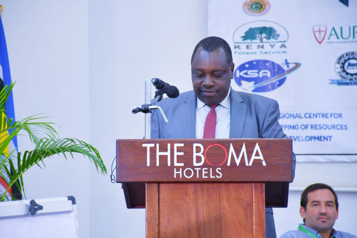
Our chief guest MBS Tom Naymorata, Secretary Administration officially opened and read the speech on behalf of the Principal Administrative Secretary (PAS) Executive office of the President during GISTC 2023 at The Boma Hotel


What I love doing in just a summary, GIS @wemappers @gischatbot @P_NdirituThuku ,@GISforAfrica @SuperMap__GIS #AfricaClimateSummit2023 @GeospatialDev_


From 10th to 12th October over 500 exhibitors await you at INTERGEO in Berlin. Get your ticket now for a chance to exchange ideas, discuss and try out new innovations and products. These and many more exhibitors await you! intergeo.de/en/tickets (Part1/2)


@SuperMap__GIS gisday 2022 flasbacks @NASAGISS

#interview |To realize the value of #geospatial #intelligence, the upstream and downstream of our entire industrial chain need to make efforts. @SuperMap__GIS is mainly in a midstream position, connecting upstream and downstream: Dr. Song Guanfu. lnkd.in/dyxbNy6Y

[EXTENDED! G-ESPO Competition 2023] Hi Geofolks! Get ready and seaten your belt, because International G-ESPO GIS Mapping competition has extend the registration date🔥🔥 🕰️: 20 August - 01 September 2023 📍: berbagi.link/gespogisicon ☎️: Yabes (+6285695097025) Join us now!


SuperMap iTablet のデータ処理機能は、10 種類のデータ分析手法、4 種類のデータ統合および投影変換をサポートしています。座標系をコピーまたはリセットすることもできます。以下のネットワーク分析のデモをご覧ください。
The data processing function of SuperMap iTablet supports 10 kinds of data analysis methods, 4 kinds of data integration and projection conversion. It can also copy or reset the coordinate system. Take a look at the demo of network analysis below.
Are you familiar with...Lowcode ? Take this opportunity to read this article by @SuperMap__GIS
Have you ever heard of LowCode? It is very popular in recent years. What if we combine LowCode and GIS? What new platform will be created if LowCode is applied to GIS applications development? Click here to check it out: bit.ly/3oFkjIr #LowCode #GIS #WorkFlow #IT

A traffic analysis using #SuperMap on the closest facilities of hospitals around Nairobi City. This data will help in case of an accident to quickly identify the nearest hospital. #geospatial companies to join us in promoting better emergency response strategies.#GIS #GISchat


This Wednesady at 5 pm E .A.T join us unleash the greatness of @SuperMap__GIS . #gischat Topic: SuperMap Training on Software deployment. Date: May 24, 2023 Location : Online via Zoom Meeting Link : us02web.zoom.us/j/87511258589?… Courtesy of @GeospatialDev_ CLUB @DeKUTkenya

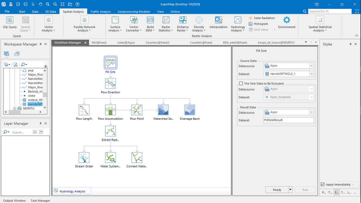
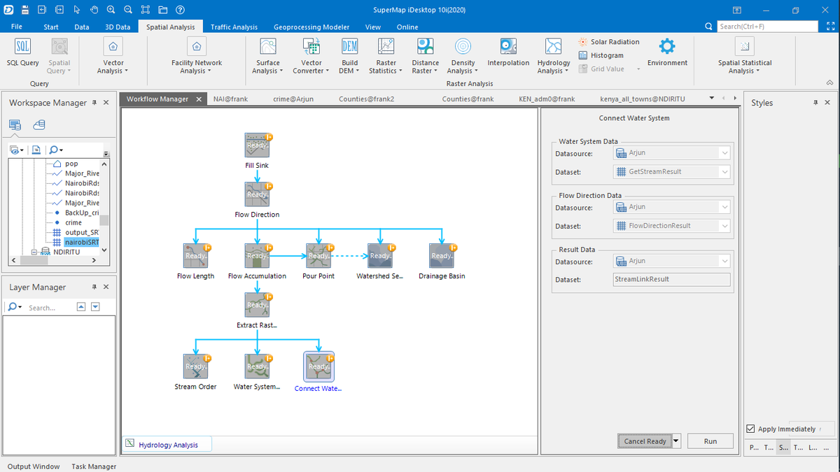
A hydrologic analysis of Nairobi's streams using #SuperMap and the results for stream order are fascinating! Understanding the flow of water in urban areas is crucial for effective water management. #hydrology #Nairobi #GIS to enhance better decisions on implemtation of drainage


📌Join us on this Summit this Wednesday 10th May 2023 and lets unleash the greatness of SuperMap courtesy of SuperMap Kenya Representative @MburuEileen🌏Theme :Introduction to SuperMap GIS Software FOR MORE INFO :+254768836667

13/01/2023..Today @gssa_tuk ,@youthmappers chapter @TU_Kenya kicked off our @SuperMap__GIS trainings.Our students got to install and interact with the SuperMap applications (idesktop, iclient,iserver and iportal).We meet again in the next session. #geospatial #GISchat #maps #GIS


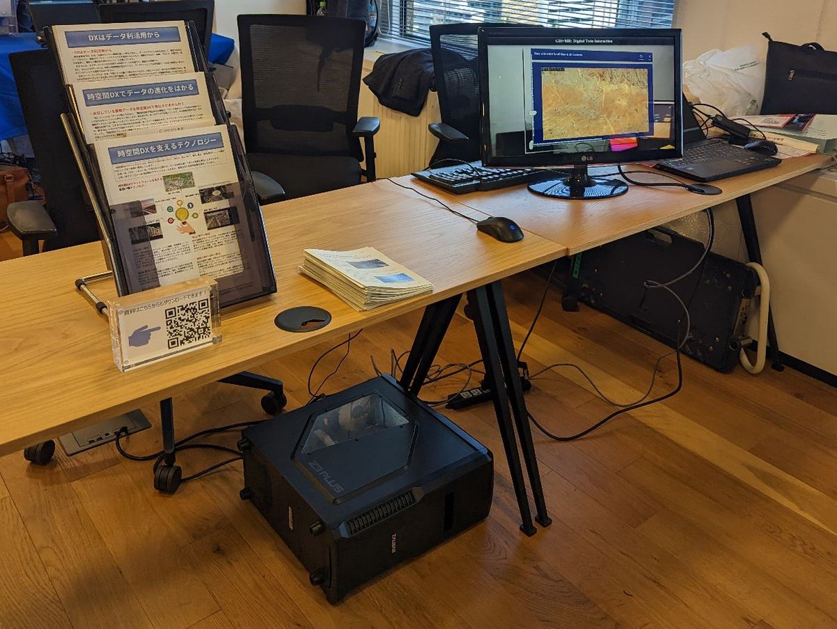
ジオ展2023に出展します プレゼンテーション時間は11:00から10分間になります。 DX時代にふさわしい時空間情報を活用した製品の紹介 詳細は下記サイトから確認いただけます。 geoten.org 展示ブース:8 参加者申込フォーム: geoten.peatix.com/view #GIS #ジオ展 #DX時代 #展示会

ゲームエンジンとの高度融合を実現したSuperMap Hi-Fi 3D for Unreal / Unity GISに美観をプラス #UnrealEngine #unity #GIS #美観
Trends for United States
You might like