Search results for #SDwx

A series of low pressure systems will continue to bring April showers to the region this weekend into early next week. #sdwx #wywx

NE Nebraska, Western Iowa, SE South Dakota Spotty/isolated flash flood potential exists with vigorous convection moving northward/northeastward through the region. #iawx #mowx #newx #sdwx wpc.ncep.noaa.gov/metwatch/metwa…

NE Nebraska, Western Iowa, SE South Dakota Spotty/isolated flash flood potential exists with vigorous convection moving northward/northeastward through the region. #iawx #mowx #newx #sdwx wpc.ncep.noaa.gov/metwatch/metwa…


ALERT: Severe Thunderstorm Warning for Lake and Miner County in SD until 3:45pm CDT. #sdwx
Severe Thunderstorm Warning for Lake and Miner County in SD until 3:45pm CDT. #sdwx


Hail Storm in #Siouxfalls #Southdakota #sdwx #weather #hailstorm

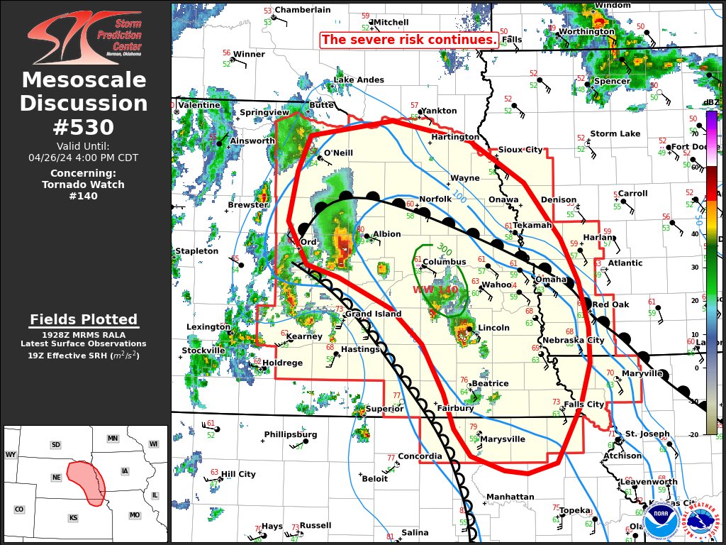

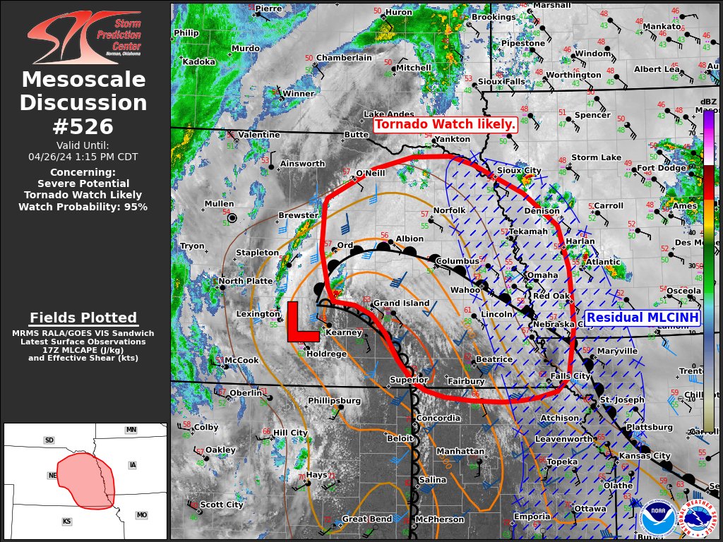
Parts of Central/Eastern Nebraska, NE Kansas into SW Iowa Scattered storm development appears likely on the dryline early this afternoon. Supercells with large to very large hail and tornadoes are possible. A Tornado Watch is likely needed. #iawx #mowx #newx #kswx #sdwx


Radar Update: 10:21 AM (04/26/2024) Heads up Dante and Avon! A strong thunderstorm has developed near Verdel, NE and should continue to push northwards at 50 mph. Frequent lightning and small hail will be possible with this storm. #SDwx

It's Arbor Day. Steady rain earlier this morning in Summit SD. Good for the farmers and for ending dust on these windy days. Hope it's warm enough for our little morel friends to pop up in the usual places. #sdwx

asdfe @sdwx
2 Followers 0 Following
#sdwx Social @sdwxSocial
157 Followers 50 Following User reported, user contributed. Send South Dakota Weather reports using #sdwx! Follow @sdwxSocial to keep up with current SD weather! Part of @SocialWeatherUS.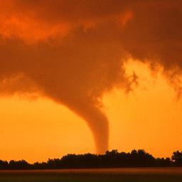


Daewon @XxXxSDWxXxX
6 Followers 1 Following
user_sdwx5577 @user_sdwx5577
189 Followers 2K Following![[2015.06.27~]달콤하게 때로는 흉폭하게(w.김철수) / 손동운(28) 초콜릿가게 사장/ 기광이형이 우주인 순정남 / 팬: 달콤 / 기광이 형옆 항시 대기](https://pbs.twimg.com/profile_images/669869992351956992/KwA5MTxz.jpg)
손동운(28)_X @Sweety_SDWX
34 Followers 10 Following [2015.06.27~]달콤하게 때로는 흉폭하게(w.김철수) / 손동운(28) 초콜릿가게 사장/ 기광이형이 우주인 순정남 / 팬: 달콤 / 기광이 형옆 항시 대기


shai @sdwx_
551 Followers 279 Following
فهد @2AKmjBghp8fSDwx
33 Followers 148 Following
Maria_022 @AX7sOuvSDWX7eQW
43 Followers 86 Following Hi!I'm directioner and i think,that Larry is REAL!!!


أحباب الروح @sdwxMKm3Weo0AyX
33 Followers 80 Following
پہہوپہہوو @SDwx6176ksNJGoQ
12 Followers 96 Following " ثُم أن يدّي لا تُلوى ، وقلبي لا يُهان ، وأنا لا أسقُط "💜
-_- @SDWX91
7 Followers 5 Following

❣Mnjeya❣ @SDWx7WyBhqJYXIa
9 Followers 30 Following
矢羽田しょーは.. @SDwxAfFPeV42931
0 Followers 1 Following
بنت الجنوب @7SDwxCy1lUEBp4d
8 Followers 60 Following ع حب الزمالك تجمعنا الخاص ممنوع اي تجاوزات بلوك

SDWx @SDWx11
12 Followers 96 Following

. @sdwx2201
2 Followers 2 Following
عزيز علو @KduSDwx370o8rMm
24 Followers 177 Following
SdwX @mister_sandy
19 Followers 246 Following
ماقدر انساك @ySdwxUVC4B0HytP
3 Followers 3 Following
Rae Pewitt @Raeoy6sdwx23u
4 Followers 0 Following Passionate travel enthusiast. Prone to fits of apathy. Certified introvert. Friendly entrepreneur. Writer
खुशमन म�.. @CUQqSuqCqG5Sdwx
12 Followers 68 Following
SDWX187 @sdwx187
3 Followers 13 Following
Samantha Weston @sdwx3
6 Followers 0 Following
Наталья @xY68sdwxUb4AvfO
4 Followers 23 Following
sdwx_gih @GIO_FER_SIQ
2 Followers 4 Following
Sebastián Salazar @sdwx2
25 Followers 0 Following

SheilaNick @y7819YYP5SDwxJ
10 Followers 1K Following
つ@英語勉強中 @x1wg5vY12SDwxW0
5 Followers 15 Following
أبو مشعل غن�.. @erMF6Sdwx6rgjeN
2 Followers 19 Following
向日葵 @o9PHHtSDWxSYC5O
0 Followers 24 Following
سالم123 @sdwx124
3 Followers 7 Following

gg @sdwx1028
79 Followers 816 Following
ابو المهند �.. @wif13oSDWxXLzN7
2 Followers 0 Following
蜂谷久美子 @uyBhegyrSdwxMUh
1 Followers 3 Following


511 @sdwx5ll
1 Followers 8 Following
pou!!( ゚∀.. @ysa1tSdwxKDUlXN
12 Followers 81 Following すとぷりすなーでございます(●︎´▽︎`●︎) 箱推しです…I˙꒳˙) 歌い手さん、ゲーム実況さんはほとんど好きです!下ネタを愛してまs(((

Ирина Шуст @NkR0l1sdwxFMAMH
1 Followers 5 Following
9455424151 @64IbSDwx6hqcwat
1 Followers 63 Following


عبدالفتاح ا.. @BudJlY0SdwxDnGA
0 Followers 0 Following

катя @sdwxK0aigv
3 Followers 32 Following
بشاير العجم.. @sdwxOeyiGzRFzVZ
6 Followers 183 Following
Swx Sdwx @SdwxSwx53213
0 Followers 1 Following

島田哲也 @SDwx12dqw0GjiYY
0 Followers 0 Following
chdnbgljgh @ort977sdwx
0 Followers 0 Following


佐野義尚 @sSDWx1fnCEi1sAf
0 Followers 6 Following

Евгений @ySsvU3TW4uSDWx9
0 Followers 0 Following
sdwx dwsqa @SdwxD63364
0 Followers 0 Following
Melinda Monguzzi @vvyxz2sdwx
0 Followers 1 Following

หน่วยซิ.. @sX84wY5gLpqSDWX
0 Followers 5 Following
Sila Meslin @sdwx_1
0 Followers 23 Following

昭史 @lvPgLZQMKqoSDwx
0 Followers 0 Following
猫黒 @4SdwxZYNUZjWXtG
1 Followers 8 Following
วรรณิศา @tFbXP2RVPThSdwx
0 Followers 38 Following

みP @SDWX6hfOOq81464
0 Followers 1 Following

Lennn Sdwx @Sw_Xianho
0 Followers 15 Following
Gabriel&Steven Callej.. @SDWxPsychoxX
0 Followers 2 Following
EricaKeynes @53Sdwx60V6J4yJq
0 Followers 3 Following If it doesn't fit, don't put it on. If you do, you will only disgust yourself and delay others.
אשר עבאדי @QVRfHzriSDWX9sC
3 Followers 0 Following


jghg @Pod5X2HxSdwxEju
0 Followers 0 Following
koumusen @0BLq1UHhBSrSDwx
4 Followers 8 Following
حکمت الله ر�.. @YLTHKDaLo4pSDWX
0 Followers 7 Following

菊島和哉 @UMcSDWX72K37216
0 Followers 2 Following
