Esri Public Safety @GISPublicSafety
Discover the power of ArcGIS to manage emergencies and the flow of public information. esri.com/industries/pub… Redlands, CA Joined July 2009-
Tweets5K
-
Followers11K
-
Following4K
-
Likes4K
From daily operations to large-scale event management, ArcGIS Mission provides a constant flow of information between command entities and field personnel. Discover what’s new in the ArcGIS Mission 11.2 release. Read more: esri.social/tBjc50RhrH9

Learn how the geographic approach can be used within your organization to acquire, evaluate, and share data across departments, agencies, and jurisdictions to improve situational awareness and enhance decision-making. Register now: esri.social/uBH250RoqlS #ES3 #EsriUC

Did you miss our webinar with @GenasysInc on the role of location intelligence in evacuation planning? Don’t worry, you can still watch the recording and learn how geographic insights can enhance public safety during emergencies. #Fire #Evacuation #PublicSafety #Webinar #GIS

In the wake of devastating wildfires, the need for effective evacuation planning has never been more urgent. Leveraging the latest technologies to revolutionize evacuation planning and execution is key. Read our blog for more information: esri.social/sgR250RhqSq

🚨Webinar Alert! – Ensure Safety & Efficiency of Fire Service Operations 👉Learn how to leverage #GIS for firefighter accountability with our partner 3AM Innovations & our special guest from Eloy Fire District. Reserve your spot today: esri.social/SyhG50RoqEL

From daily operations to large-scale event management, ArcGIS Mission provides a constant flow of information between command entities and field personnel. Discover what’s new in the ArcGIS Mission 11.2 release. Read more: esri.social/Z6Xa50RhpWT

Learn how the geographic approach can be used within your organization to acquire, evaluate, and share data across departments, agencies, and jurisdictions to improve situational awareness and enhance decision-making. Register now: esri.social/uBH250RoqlS #ES3 #EsriUC

In the wake of devastating wildfires, the need for effective evacuation planning has never been more urgent. Leveraging the latest technologies to revolutionize evacuation planning and execution is key. Read our blog for more information: esri.social/QnNg50RhqRS

🚨Webinar Alert! – Ensure Safety & Efficiency of Fire Service Operations 👉Learn how to leverage #GIS for firefighter accountability with our partner 3AM Innovations & our special guest from Eloy Fire District. Reserve your spot today: esri.social/ZFok50Rok6H

In the wake of devastating wildfires, the need for effective evacuation planning has never been more urgent. Leveraging the latest technologies to revolutionize evacuation planning and execution is key. Read our blog for more information: esri.social/K9bp50RhqOJ

🚨Register Now: esri.social/1coX50Rojb7 👉Discover how to leverage #GIS for firefighter accountability with our partner 3AM Innovations & our special guest from Eloy Fire District. Learn how to use GIS to enhance situational awareness, incident management, & post-incident review.

When Fort Lauderdale was hit by a deluge that caused substantial damage, mapping the damage helped city responders secure funds to restore the city quickly. Read More: esri.social/kB4k50Rhssh

When Fort Lauderdale was hit by a deluge that caused substantial damage, mapping the damage helped city responders secure funds to restore the city quickly. Read More: esri.social/kpzM50RhsqO

Discover how the City of Rochester Hills, Michigan, streamlined delivery of fire education and resources to the community with our survey management solution. Find out more: esri.social/MWht50RhoAN

Discover how the City of Rochester Hills, Michigan, streamlined delivery of fire education and resources to the community with our survey management solution. Find out more: esri.social/ATuP50RhoBe

When Fort Lauderdale was hit by a deluge that caused substantial damage, mapping the damage helped city responders secure funds to restore the city quickly. Read More: esri.social/kB4k50Rhssh

In the wake of devastating wildfires, the need for effective evacuation planning has never been more urgent. Leveraging the latest technologies to revolutionize evacuation planning and execution is key. Read our blog for more information: esri.social/vJs850RhqTQ

👉🚨This National Public Safety Telecommunicators Week, we honor the crucial work of the first, first responders. At Esri, we remain dedicated in supporting telecommunicators with advanced solutions to empower their impact! Learn more: esri.social/ThVG50RjjVZ

We can’t wait to see you this summer at @EsriUC! ☀️ Join us at the largest GIS event of the year. Network, see the latest ArcGIS technology, and much more. 🔹Register: esri.social/OSBc50RgFzI #EsriUC2024

Discover how the City of Rochester Hills, Michigan, streamlined delivery of fire education and resources to the community with our survey management solution. Find out more: esri.social/1C6T50RhnzY


🥔🗺️ ᴘᴏᴋ.. @pokateo_maps
25K Followers 3K Following 👋🏻 I'm Kate ᵉᵃᵗᵉʳ ᵒᶠ ᵖᵒᵗᵃᵗᵒᵉˢ ᵃⁿᵈ ᵐᵃᵏᵉʳ ᵒᶠ ᵐᵃᵖˢ 🌐 I make #geospatial & #GIS (more) fun by sharing #mappymeme s & #maptastic themes. Hosts #GISchat. ᵛᶦᵉʷˢᵐᶦⁿᵉ
josephkerski @josephkerski
14K Followers 2K Following Geography, geo-geekiness, STEM, ed tech, space, place, geographic information systems (GIS), GPS, outdoor education 365 days a year.
Esri @Esri
193K Followers 70K Following Esri builds #ArcGIS, the leading location intelligence and spatial analytics software for mapping, 3D GIS, imagery, and geospatial app development.
Esri Training @EsriTraining
33K Followers 1K Following Advancing geospatial capabilities of individuals, teams, and organizations is our mission and our passion.
Simon Kuestenmacher @simongerman600
268K Followers 230K Following German #geographer and #demographer in #Melbourne. I curate #maps and #data that explain how the #world works. Obviously all opinions are my own...
Derek Law @GIS_Bandit
6K Followers 1K Following Product Manager @Esri | Interests #GIS, #HealthGIS, #Maps, #DataViz Bluesky: https://t.co/wQd6s7i22E Comments are my own.
michael GOULD (@mgoul.. @0mgould
11K Followers 3K Following GIS professor and Global Education Manager at Esri (opinions my own). #travel #mountainbike #internationalDev #GIS #Spain #sarcasm
Esri GIS Education @GISEd
20K Followers 728 Following Esri GIS Education - news, curriculum, software, tools and more

P.J. Doherty @pjdohertygis
4K Followers 4K Following Supporting search and rescue teams with geospatial tools. All opinions are my own, not representing my employer. #SAR #publicsafetygis #GIS
ArcGIS Survey123 @ArcGISSurvey123
8K Followers 373 Following Smarter forms, smarter decisions! Included with ArcGIS.
Adam Carnow @SpatialAce
3K Followers 3K Following Public Works Industry Specialist @Esri. Opinions are mine. Bottom line: I help people make better decisions with the power of location. https://t.co/vHWEFg5b5v
Joe Lowry @PreparednessJoe
3K Followers 2K Following Emergency Manager for a large white domed building on a hill 🏛 Former FF 🧑🏼🚒 @JohnCarrollU grad ⚡️ #EMGTwitter 🙋🏼♂️ Youngstown-American. Views are mine.
Cascadia Fire Has No .. @barkflight
17K Followers 12K Following Staff reporter @watchdutyapp, covering wildfires in the American West. Incident tweets are unofficial and not emergency advice. All tweets my own.
Esri Partners @EsriPartners
6K Followers 2K Following For GIS and location intelligence customers and prospects for news, trends, and solutions from Esri’s Global Partner network.
Krista West, Ph.D. @RSFireNerd
4K Followers 4K Following Pyrogeographer. #RemoteSensing of Wildfire. 🛰🛩🔥 | Passionate about finding ways to help first responders 👩💻❤️🚒

NAPSG Foundation @napsgfoundation
2K Followers 895 Following #Nonprofit dedicated to building the #publicsafety community's #geospatial #technology capability & providing #GIS subject matter expertise.
National Interagency .. @NIFC_Fire
18K Followers 2K Following The National Interagency Fire Center, or NIFC, is located in Boise, Idaho and is the nation's support center for wildland firefighting.
Ashley Morris @MissAshes92
7K Followers 6K Following CEM | MDPEMP | NEMAA | MD Emergency Management | Prep Plans & Alerts OH MY! | IMT | SMEM | SVI | Meteorology | Geoscientist | @OKSTATE PhD Pupil 👩🏫 | ♥️🚒

Cristian Alvarado IG:.. @cristialvaprie
102 Followers 1K Following Ingeniero Geógrafo y Ambiental. Melómano. Fanatico del cine. Amante de la naturaleza.
Smart Cities Connect @smartcityc
17K Followers 18K Following We provide meaningful content and connect a thoughtful community of decision-makers to empower smart cities at all stages of growth. Powered by @techconnect360.
محمد بن أحم�.. @mohamedpt9
12 Followers 801 Following الحمد لله اللهم ارحمني وسددني واهدني استغفر الله
Guemil Icons @Guemil_Icons
473 Followers 1K Following Icons-based initiative to dialog on risk & emergency | Iniciativa basada en iconos para dialogar sobre riesgo y emergencia | Open Source | Premio ChileDiseño 21
GIS Analyst Expert & .. @Abidjahan6
549 Followers 1K Following GIS Analyst Expert: Remote Sensing & Data Visualization Specialist
olivia olaughia olovi.. @olivia_j_t
599 Followers 770 Following giants baseball & many other complaints • ucsb

Jennifer Gold @jfarrellgold
113 Followers 728 Following CTO | Cybersecurity Board Advisor | Speaker | #redteam #usmccyber #infragard #nsdar | All opinions expressed are my own.
SusanHubbard @mOVkiKfdb9vR14L
36 Followers 1K Following
K_Felix @k_felix20
691 Followers 905 Following Urban Planner🧭||GIS🌏|| #KNUST 💚 ||Ghana will be Great🇬🇭|| @ManUtd 🔴 || @realmadrid ⚪
Fahad Alahmadi @FahadAhmadi
20 Followers 153 Following


Rat Race in Manhattan.. @TatsuyaSekan
357 Followers 5K Following CHD SIT U of Alabama Civil Eng. Henan Exodus. MicrosoftBoo. Research interest: OR GIS CSS ABM RL
Dalia Elfiky @elfik51455
6 Followers 159 Following
Gabriel LEJEUNE @gabriel_lejeune
25 Followers 800 Following
Podcast Review Brasil @podcastreviewbr
5K Followers 408 Following Acervo de críticas de podcasts brasileiros
أحمد عبد ال�.. @a7m6dm0hamm6d
6 Followers 188 Following
Edward @EdwardHarryDay
7 Followers 148 Following
Kyle Burke @KBur05
25 Followers 180 Following
Tom Searing @FalconA26r
18 Followers 47 Following Remote Sensing SME, Drone Pilot, Aviation Enthusiast
Gerald @Gerald91032403
9 Followers 70 Following
vitama 117 @vitama117
1 Followers 27 Following Software developer, GIS specialist, ArcGIS professional
ChrisJRoss13 @ChrisJRoss13
22 Followers 255 Following Engineering and geomatics enthusiast with a passion for the great outdoors. Always looking for new ways to combine my love of technology and nature.
Guy Leven-Marcon @GuyLeven23667
32 Followers 145 Following
Royce @Royce330
12 Followers 1K Following
Patel D K @DrshtapUs
3 Followers 90 Following
karim emad @Karimemad2030
0 Followers 47 Following
Mohammad Aljaber @1984Jaber
9 Followers 131 Following
It's Nate @oweya_nathan
106 Followers 361 Following Just being Nate😎 Man U ♥️ GIS & Remote sensing expert, Developer and enthusiast.
nvrm.rj @RjNvrm
4 Followers 74 Following
Nahui Olin @atl_altepetl
20 Followers 312 Following Barrera Cruz Angel Daniel Entusiasta de Mapas|Idiomas|Cocina y 1001 Cosas más. Redes ig: @nahuinoestaaquí
Forres @Forreswing
6 Followers 105 Following
Ezgi @ezgisar
29 Followers 35 Following
Ahmed Helmy @ahmedhelmyumar
171 Followers 1K Following خبير وعاشق لنظم المعلومات الجيومكانية، ومحب لمشاركة المعرفة
OSINTxAndretti @osintandretti
6 Followers 78 Following
Shuvo S.R.S. @Shuvo_5R5
53 Followers 202 Following A deconstructed lone wolf, sentiently jotting down temporal and spatial changes. A storyteller!
Jordan Baumgardner @BlueTurtleDev
41 Followers 114 Following
Aikazumie @aikazumie
18 Followers 311 Following

Luke Aspinall @LukeAspinall6
246 Followers 3K Following
Sarmad @Sarmad01436591
13 Followers 129 Following
yutaro eidai @EidaiYutaro
24 Followers 104 Following
Chris Seidt @chrisseidt
587 Followers 2K Following Husband, dad, basketball official, IT leader. Opinions shared on this account are my own.
Chris Leto @chris_leto39995
13 Followers 19 Following
LeighannOsnoe @LeighannOs65760
40 Followers 2K Following
BaseballGURU @baseball79660
2 Followers 50 Following
Jack @Ajax97x
283 Followers 427 Following I have many hobbies. A master of none. Fishing, kayaking, beer, GIS, indie rock, hunting, hiking, politics, guns, video games... etc
🥔🗺️ ᴘᴏᴋ.. @pokateo_maps
25K Followers 3K Following 👋🏻 I'm Kate ᵉᵃᵗᵉʳ ᵒᶠ ᵖᵒᵗᵃᵗᵒᵉˢ ᵃⁿᵈ ᵐᵃᵏᵉʳ ᵒᶠ ᵐᵃᵖˢ 🌐 I make #geospatial & #GIS (more) fun by sharing #mappymeme s & #maptastic themes. Hosts #GISchat. ᵛᶦᵉʷˢᵐᶦⁿᵉ
josephkerski @josephkerski
14K Followers 2K Following Geography, geo-geekiness, STEM, ed tech, space, place, geographic information systems (GIS), GPS, outdoor education 365 days a year.
Esri @Esri
193K Followers 70K Following Esri builds #ArcGIS, the leading location intelligence and spatial analytics software for mapping, 3D GIS, imagery, and geospatial app development.
Esri Training @EsriTraining
33K Followers 1K Following Advancing geospatial capabilities of individuals, teams, and organizations is our mission and our passion.
Dr. Dawn Wright + @de.. @deepseadawn
23K Followers 958 Following Aquanaut + Chief Scientist of @Esri + @OregonState GIS/oceans professor, cyclist, 1st Black diver to #ChallengerDeep, builds w/LEGO, raised in Hawaii.
Simon Kuestenmacher @simongerman600
268K Followers 230K Following German #geographer and #demographer in #Melbourne. I curate #maps and #data that explain how the #world works. Obviously all opinions are my own...
Derek Law @GIS_Bandit
6K Followers 1K Following Product Manager @Esri | Interests #GIS, #HealthGIS, #Maps, #DataViz Bluesky: https://t.co/wQd6s7i22E Comments are my own.
michael GOULD (@mgoul.. @0mgould
11K Followers 3K Following GIS professor and Global Education Manager at Esri (opinions my own). #travel #mountainbike #internationalDev #GIS #Spain #sarcasm
Esri GIS Education @GISEd
20K Followers 728 Following Esri GIS Education - news, curriculum, software, tools and more

Sarah Bell @sarahbellmaps
11K Followers 453 Following Cartographer, Dataviz, Geospatial scientist, & cartography author always pursuing creative visualization @esri You'll find me either rock climbing or map-making
P.J. Doherty @pjdohertygis
4K Followers 4K Following Supporting search and rescue teams with geospatial tools. All opinions are my own, not representing my employer. #SAR #publicsafetygis #GIS
Spatial Trouble Maker.. @Todd_Effin_Barr
10K Followers 7K Following Queer/ENBY AF 🏳️🌈🏳️⚧️ I work in the Natural Disaster/Climate/ESG Space, figuring out where Geospatial helps solve the puzzle. Unapologetic Ke$ha Fan
ArcGIS Survey123 @ArcGISSurvey123
8K Followers 373 Following Smarter forms, smarter decisions! Included with ArcGIS.
Adam Carnow @SpatialAce
3K Followers 3K Following Public Works Industry Specialist @Esri. Opinions are mine. Bottom line: I help people make better decisions with the power of location. https://t.co/vHWEFg5b5v
Esri Partners @EsriPartners
6K Followers 2K Following For GIS and location intelligence customers and prospects for news, trends, and solutions from Esri’s Global Partner network.
Women In GIS @womeningis
5K Followers 198 Following Promoting, Supporting, Encouraging, Building, Leading - Women In GIS
Krista West, Ph.D. @RSFireNerd
4K Followers 4K Following Pyrogeographer. #RemoteSensing of Wildfire. 🛰🛩🔥 | Passionate about finding ways to help first responders 👩💻❤️🚒
NAPSG Foundation @napsgfoundation
2K Followers 895 Following #Nonprofit dedicated to building the #publicsafety community's #geospatial #technology capability & providing #GIS subject matter expertise.
MalibuPublicSafety @MalibuSafety
3K Followers 47 Following City of Malibu Public Safety Dept official account. Comments violating our Terms of Use will be deleted & preserved: https://t.co/GfvJWVTM4B…
Tedros Adhanom Ghebre.. @DrTedros
2.0M Followers 2K Following Director-General of the World Health Organization. Retweets are not endorsements
Philadelphia Fire @PhillyFireDept
40K Followers 1K Following Dedication + Service #24x7x365. Contact 911 for emergencies and @Philly311 for non-emergencies. Alerts: @PFDalerts. Sponsor of @PATaskForce1. #PFDstrongtogether

The American Geograph.. @AmericanGeo
12K Followers 4K Following The first national geographical organization in the United States. Nonprofit organization spreading geographical and geospatial awareness since 1851.
Holly Blanks @hollyblanks
570 Followers 88 Following Ms. Blanks interacts with public safety agencies around the globe, absorbing their best practices while introducing them to emerging technologies.
jackdangermond @jackdangermond
414 Followers 0 Following President and founder of Esri. To learn more about Esri, follow @Esri.
Stephen Lai @slaiguy
208 Followers 555 Following Father Husband Geographer & Data Guy | Helping empower people through data | Tweets are my own and don’t reflect my employer.
Kyle Gruber @NimbusHex
255 Followers 1K Following Software Engineer, Purdue/Steelers/Penguins/Tottenham fan, metalcore enthusiast, public safety technology evangelist, idiot. Views are my own.
HOPE Team @SBCSDHOPE
2K Followers 462 Following The San Bernardino County Sheriffs Department CSRD Homeless Outreach Proactive Enforcement, HOPE Team represents a more effective approach to homelessness.
Toronto Fire @tofire
15K Followers 7 Following @tofire - Toronto Fire Active Incidents - In Emergency call #911. Brought to you by @ijg
Salesforce Marketing .. @MarketingCloud
181K Followers 81K Following The future of business is CRM + AI + Data + Trust. Discover marketing built on the world’s #1 CRM. For help 👉 @asksalesforce
Dreamforce @Dreamforce
127K Followers 2K Following Explore CRM + AI + Data + Trust built for your industry at #SalesforceTour NYC: https://t.co/ayCchWrZDw
Salesforce @salesforce
588K Followers 138K Following 👋 We're Salesforce, the Customer Company. CRM + AI + Data + Trust. Need help? Tweet @AskSalesforce for support.

FirstNetTech @FirstNetTech
3K Followers 3K Following Tweeting about #FirstNet & game changing technology for #FirstResponders - Big fan of but not affiliated in any way with FirstNet.
PowerOutage.us @PowerOutage_us
16K Followers 491 Following https://t.co/FlQYb4Em4z is an on going project created to monitor and record #PowerOutages in the #UnitedStates. Follow for updates on major #PowerOutage events.
Michael Sprayberry @DirectorNCEM
1K Followers 168 Following
Patrick Lane @LanePatrick
15 Followers 60 Following
EntertainMaps @EntertainMaps
651 Followers 277 Following Where sports, television & pop culture meet geography.
Dennis Bickmeier @DennisBickmeier
5K Followers 3K Following Executive Director Henrico County Sports & Entertainment Authority; Former Richmond Prez; Sports Fan; #NASCAR, #Buckeyes # Steelers Fan #Golf #RVA. @OhioU Grad
Mark W. Light, CAE @mwlight
368 Followers 88 Following Association and Public Safety professional and CEO. Retweet does not equal an endorsement
Todd J. LeDuc @ToddJLeDuc
6K Followers 4K Following Ret. Fire Chief; Deputy CEO @Life Scan Wellness; IAFC Safety, Health & Survival Board; Editor Surviving the Fire Service; TC Member NFPA; Opinions my own.
Fire-Rescue Int'l @FireRescueIntl
3K Followers 232 Following There has never been a more essential time for the fire and EMS community to come together. Hurry, register now: https://t.co/sdss70zJc3 #FRI2021Orland Fire @OrlandFire
106 Followers 1 Following The Orland Fire Protection District is dedicated to preserving life and property while valuing full accountability to each other and the people we serve.
Eric Shreve @EshreveAZ
745 Followers 4K Following
Stephen Nearing 🇺�.. @nearins
587 Followers 575 Following 🌟 Data Storyteller 📊 | 🔥 Former Chief Level Fire Officer 🚒 | 🚀 Monkeys-as-Astronauts Enthusiast 🐒 | 🙄 Professional Doubter 🤔
Katherine Gutermuth @MKatieG249
212 Followers 938 Following District Court Commissioner Maryland-Graduate from the University of Maryland with a B.S. in legal studies. Wilmington University M.S student
Silvio Lanzas @Slanzas_1075
2K Followers 3K Following Husband,Dad,Proud🇺🇸. ❤️MyFamily, TheFD,Cowboys🏈Angels⚾️. LiveALifeOfService! GETUP, DRESSUP, SHOWUP, NEVERGIVEUP! Follows, tweets and retweets 🚫 endorsed

RTD @RideRTD
36K Followers 129 Following Denver | Boulder | Aurora metro area’s transit system, servicing 141 bus routes, 8 light rail lines and 4 commuter rail lines. Tweet us Mon-Fri, 6am-6pm MST.
Jordan Cullen @JCullenNow
2K Followers 524 Following Product marketing in tech 💻 | @USArmy GWOT Vet 🪖 | @UCRiverside & @USC alumnus ✏️ | Tweets about veterans, military, business, mental health, etc.

Chris Delaney @CDelaney585
54 Followers 342 Following
CobbCountyGIS @CobbCountyGIS
426 Followers 114 Following Connecting people, processes and things for a smart Cobb County using maps, apps and location intelligence data. Email: [email protected]


Linda Beale @lindabeale
461 Followers 32 Following Group Lead Product Engineer, Educator and snowboarder.
John Hawkins @JhawkFire
8K Followers 8K Following Wildland Fire Consultant - Fire Chief (ret) Formr CALFIRE/RivCo Fire Chief 12yrs - 55yrs FireServ LoveFF's & Serv'nPublic TransformationalServantLdr
Josh @josh_t84
48 Followers 152 Following Husband, Father, Medic/FF. Franklin County Department of Public Safety.

Fire Fighting in Cana.. @FireinCanada
6K Followers 843 Following Fire Fighting in Canada is the country's No. 1 fire-service publication.
SSF Fire Department @SSFFire
3K Followers 1K Following This is the official Twitter page for the South San Francisco Fire Department. This page is not monitored 24/7, for emergencies please call 9-1-1.
Danilo Palermo @Danilo_Palermo
78 Followers 204 Following
Jeff Hughes @jhughesNCR
411 Followers 495 Following District Manager at Esri Canada National Capital Region, Interested in GIS and Esri in the NCR and beyond!
Nikki Golding @goldingnik
295 Followers 204 Following Former Tweep, lover of music and seeker of fun |(she/her) #freebird 🌴🧘♀️
Mark Bornstein @4markb
2K Followers 412 Following Content Marketer, Public Speaker, Big Dreamer, Occasional sleeper.
Maryland Society of S.. @MDSurveyors
234 Followers 97 Following News and information from the Maryland Society of Surveyors.
Just_In_GIS @Just_in_GIS
31 Followers 26 Following Keeping up with and presenting trending topics in the GIS industry
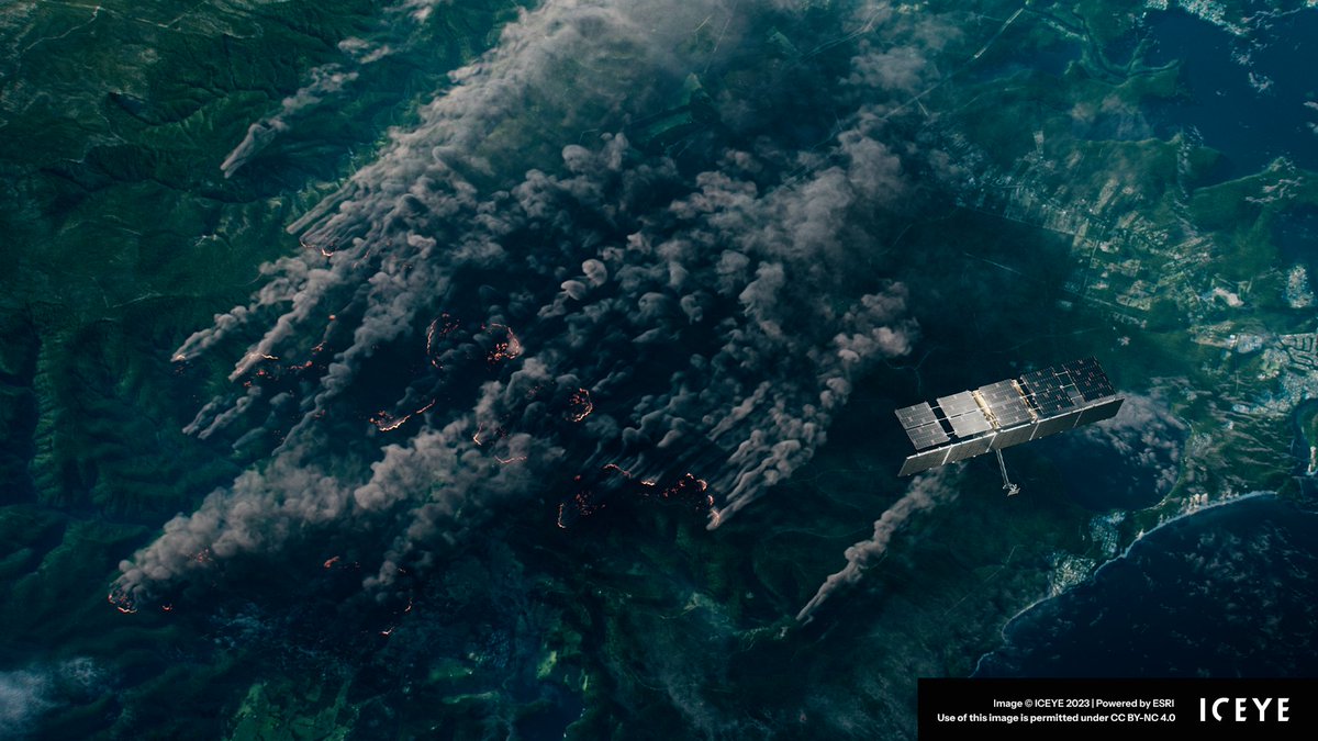
The Federal Government of Australia have partnered @iceye to access near real-time flood and bushfire hazard data for all states and territories. Using Esri tech, the Federal Government of Australia can deliver actionable insights during natural catastrophe events.


The countdown is on! Now is the best time to start planning your GIS Day event. Find resources for hosting at gisday.com

Read this case study to learn all about how @CvilleFireDept modernized their field data collection workflow using #ArcGISFieldMaps. @GISPublicSafety Link ➡️ esri.social/mOuB50Pthi2

Read this blog to learn how #ArcGISAllSource can be used to help combat fraudulent activity through location intelligence. @Esri_Defense @GISPublicSafety Link ➡️ esri.social/gtOI50PlYPG


Proud to sponsor the Fire Rescue EMS SIG at the #EsriUC2023! Thanks to @HFDCh5 and @GISPublicSafety for the invite! #BCS25


Looking forward to attending #FRI2023 with @GISPublicSafety from #Esri!
Introduction to the no-cost Fire Accreditation Analysis from @Esri and @GISPublicSafety that supports geospatial workflows for Community Risk Assessments (CRA) and Standard of Cover (SOC) development doc.arcgis.com/en/arcgis-solu…

Content from @Esri: Ryan Lanclos, Director of National Government & Public Safety Solutions at Esri on the future of disaster response “GIS is what we are talking about today, is the tool that allows us...to ask questions about various options...to make decisions in real time"
Content from @Esri: Ryan Lanclos, Director of National Government & Public Safety Solutions at Esri shares how data, geography and mapping factor into the protection of vulnerable people and homes in the path of a disaster event.
Content from @Esri: Director of National Government & Public Safety at Esri, Ryan Lanclos discusses how Esri and emergency managers are using geographic information systems to address ongoing climate challenges and the effects GIS has on humanitarian and public health efforts.
Are you an intelligence professional attending the UC? Tap the link to learn about ArcGIS AllSource & stop by our booth! AllSource enables intelligence analysts to process & visualize data to uncover actionable intelligence quickly! esri.social/JTg550OUr2m @GISPublicSafety
#Mobile is here! You can now configure mobile view dashboards with the newest release of #ArcGISDashboards in #ArcGISOnline! Get the scoop on all of the latest features in this blog: esri.social/C9I050OMsg1 @GISPublicSafety

RT @GISPublicSafety ArcGIS Solutions for Implementing Evidence-Based Responses to Crime Problems Webinar, June 13 ow.ly/y1Mx50OKOut

ArcGIS Mission's connection to #ArcGISEnterprise enables you to run daily security operations utilizing historical data, new intel from the field, and live data feeds, all combined in real time. Read more in ArcNews: esri.social/Gr3150OjTax #ArcGISMission @GISPublicSafety

ArcGIS Mission's connection to ArcGIS Enterprise enables you to run daily security operations utilizing historical data, new intel from the field, and live data feeds combined in real time. Learn more in the blog: esri.social/rCHE50OjSBq #ArcGISMission @GISPublicSafety

ArcGIS Mission's connection to #ArcGISEnterprise enables you to run daily security operations utilizing historical data, new intel from the field, and live data feeds, all combined in real time. Read more in ArcNews: esri.social/IJti50OjT3T #ArcGISMission @GISPublicSafety

Track activity with change detection in #ArcGISExcalibur. Streamline visual analysis through tools that make finding differences in imagery & pulling insights easy. Learn how to use the Detect Change tool: esri.social/xTZR50NIFhU @EsriFederalGovt @EsriSLGov @GISPublicSafety #GIS

ArcGIS Mission's connection to ArcGIS Enterprise enables you to run daily security operations utilizing historical data, new intel from the field, and live data feeds combined in real time. Learn more in the blog: esri.social/3s5g50OjSta #ArcGISMission @GISPublicSafety


Please take a moment to review what could be the biggest change in #NIMS #ICS in years!! @GISPublicSafety @Esri @AHIMTA esri.com/en-us/industri…
Trends for United States
You might like