NAPSG Foundation @napsgfoundation
#Nonprofit dedicated to building the #publicsafety community's #geospatial #technology capability & providing #GIS subject matter expertise. napsgfoundation.org USNG 18S UJ 1935 1445 Joined September 2010-
Tweets3K
-
Followers2K
-
Following895
-
Likes183
Another great topic from JHU After Dark. Registration is free but ends soon! #CrimeAnalysis ow.ly/VOR250Rr4zb
Don't miss out on the next webinar from URISA's Climate and Community Resilience Committee, which will include an exceptional guest speaker -- Associate Professor John Finn.

Don't miss out on the next webinar from URISA's Climate and Community Resilience Committee, which will include an exceptional guest speaker -- Associate Professor John Finn.

FEMA needs your input! Please consider providing feedback on the draft 𝙉𝙖𝙩𝙞𝙤𝙣𝙖𝙡 𝙍𝙚𝙨𝙞𝙡𝙞𝙚𝙣𝙘𝙚 𝙂𝙪𝙞𝙙𝙖𝙣𝙘𝙚. The feedback period closes 5/23/24. 𝗩𝗶𝗲𝘄 𝘁𝗵𝗲 𝗱𝗿𝗮𝗳𝘁, 𝗳𝗲𝗲𝗱𝗯𝗮𝗰𝗸 𝗳𝗼𝗿𝗺, & 𝘄𝗲𝗯𝗶𝗻𝗮𝗿 𝘀𝗰𝗵𝗲𝗱𝘂𝗹𝗲: fema.gov/emergency-mana…

Congrats to @PinellasGov and #InSPIRE alumni for continuing to push the needle forward and investing in resilience.

Congrats to @PinellasGov and #InSPIRE alumni for continuing to push the needle forward and investing in resilience.

Don't miss out on today's PrepTech Talk! Learn how NERIS will empower the fire and emergency services community with robust data analytics and geospatial tools. @usfire @dhsscitech @FSRI_org (ow.ly/qIRo50Rcrsc)

Did you know USFA will be launching a new interoperable fire information and innovative analytics platform known as NERIS? Register for this no-cost webinar to learn all the details! (ow.ly/xCAK50R4kpE)

Join experts from USFA, Fire Safety Research Institute, and DHS Science & Technology to learn how NERIS will empower the fire and emergency services community with robust data analytics and geospatial tools. #GIS (ow.ly/plKC50QX6zO)

Breaking NERIS News! 6 local fire departments have successfully onboarded onto the new National Emergency Response Information System (NERIS) & started reporting local emergency incident information through the new system. @FSRI_org @dhsscitech @fema usfa.fema.gov/about/media-re…
Don't miss out on today's PrepTech Talk! This no-cost webinar will cover cutting-edge ways GIS is revolutionizing law enforcement! From field ops to strategic planning, see how data is transforming the fight against crime in CA and MD. (ow.ly/Yh2t50QSfKB)

GIS is revolutionizing law enforcement! From field applications, to tactical and strategic dashboards, managing sensitive data, and empowering line-level personnel with geospatial tools, GIS is changing how law enforcement operates. ow.ly/K38350QQkhX

Interested in how AI might be best utilized in emergency management, especially with regard to geographic data? Check out URISA's next free webinar.
Interested in how AI might be best utilized in emergency management, especially with regard to geographic data? Check out URISA's next free webinar.

Discover how GIS is revolutionizing law enforcement operations! From tactical dashboards to field applications, geospatial tools are changing the game. Don't miss our next PrepTech Talk! #GIS #PublicSafety #LawEnforcement ow.ly/R0Fb50QKJcC

"Meet Brooke Hatcher, a senior geospatial analyst at New Light Technologies who creates stories to help clients understand which areas are going to be most vulnerable and who are at the most risk of disasters." See this Instagram photo by @theAAG instagram.com/p/C3rD8_7M-GO/…
#SARCOP was highlighted along with other amazing applications for disaster preparedness and response at #EsriFedUC2024.

Jared Doke (NAPSG) presenting on #SARCOP to help inform attendees on why location sharing is critical for public safety operations. #EsriFedUC2024

It was amazing to see our work featured, in coordination with the @IAFC, on the use of geospatial tools to help with firefighter recruitment, at #EsriFedUC2024.


Connecting research to practice at @napsgfoundation InSPIRE 2023 with Kate Kapalo, Chad Council, Wenwu Tang, and Sonny Kirkley. #InSPIREtheMap


Congratulations to Jeff Baranyi of @GISPublicSafety for being awarded by NAPSG Foundation for his work in #GIS #InSPIREtheMap


Learning about taxonomies, ontologies, and schema at @napsgfoundation InSPIRE 2023 with @pjdohertygis, Carmen Zapata, and Trent Tinker. #InSPIREtheMap


P.J. Doherty @pjdohertygis
4K Followers 4K Following Supporting search and rescue teams with geospatial tools. All opinions are my own, not representing my employer. #SAR #publicsafetygis #GIS
Washington State Dept.. @waDNR
150K Followers 7K Following Managing, sustaining, and protecting the health & productivity of Washington's lands and waters. 👤@Hilary_FranzCPL 🔥@WaDNR_Fire 🌲@waDNR_Forests
Cascadia Fire Has No .. @barkflight
17K Followers 12K Following Staff reporter @watchdutyapp, covering wildfires in the American West. Incident tweets are unofficial and not emergency advice. All tweets my own.
Krista West, Ph.D. @RSFireNerd
4K Followers 4K Following Pyrogeographer. #RemoteSensing of Wildfire. 🛰🛩🔥 | Passionate about finding ways to help first responders 👩💻❤️🚒
Ashley Morris @MissAshes92
7K Followers 6K Following CEM | MDPEMP | NEMAA | MD Emergency Management | Prep Plans & Alerts OH MY! | IMT | SMEM | SVI | Meteorology | Geoscientist | @OKSTATE PhD Pupil 👩🏫 | ♥️🚒
Derek Law @GIS_Bandit
6K Followers 1K Following Product Manager @Esri | Interests #GIS, #HealthGIS, #Maps, #DataViz Bluesky: https://t.co/wQd6s7i22E Comments are my own.
Joseph Elfelt https:/.. @MappingSupport
4K Followers 255 Following My new content is on Mastodon, not here Developer of https://t.co/PUG9Ce2Uon - Your property lines on Google aerial. See https://t.co/x7r8jsQOSH for my other projects.
Zach Stanford @zachstanford
2K Followers 4K Following Emergency Management & Homeland Security | Risk & Hazard Comms + Maps | Cares too much about emergency alerts | Opinions = mine | ENTP | WX5OEM | #EMGTwitter
CEDR Digital Corps @CEDRdigital
8K Followers 966 Following Digital Helpers During Disasters to clarify, amplify, & inform. Not 24x7▪501c3▪❤/RT🚫endorsement https://t.co/mvg3np6Rln https://t.co/rD7U3cM6J6
Jim Whittington🔥 @JimWhittington
3K Followers 1K Following Retired BLM/NPS/USFS - now @OSUCEOAS. Tweets on🔥, incident mgmt, & crisis comms. Birthday: 318.51 ppm. More time on Sky than Post or Mast.
Geographreak🗺 @maddiewithamap
789 Followers 975 Following Hazardscape geographer. PhD candidate. Transportation policy planning afficionado. Feminist. Chronic migraineur.
StuPal @stuartpalley
22K Followers 4K Following Photographer, writer, speaker maker | Into The Inferno https://t.co/bEMB9wPbpC|
Esri @Esri
193K Followers 70K Following Esri builds #ArcGIS, the leading location intelligence and spatial analytics software for mapping, 3D GIS, imagery, and geospatial app development.
Dave Statter @STATter911
42K Followers 11K Following Dispatches from the rabbit hole from a senile, crazy gadfly who--in his more lucid moments--provides fire and EMS news.
Lorri Peltz-Lewis @lapeltz
934 Followers 1K Following GISc, GISP, ASPRS GIS/LIS, Earth Sciences (Hydro, Fire Sci, Geol, Geog, Bio, Marine Sci), Modeler, BAER, USFS FAM CA, UAS/UAV, Data Warehousing, etc.
Jennifer Lazo @Jdlazo
2K Followers 1K Following SoCal Local Govt. Emergency Manager. Musical/Disney/#UglyDogs/total geek. My tweets are my own- they don't represent any organization. She/Her.
Gerry @Gerry_eff_P
55 Followers 1K Following
José G.M. @JCGarciaSC13
89 Followers 1K Following Arquitecto Revit. Sketchup, enscape, D5, lumion, autocad, arc gis Sporting Cristal 💙💙💙💙 Sigero 🦂
MJKiss @MJKiss283784
0 Followers 51 Following
Jennifer Ramirez🌳�.. @jenjen_pr
534 Followers 1K Following Project Manager | Photographer | Coffee Enthusiast | Dog Mom | Plant Lover
GeoCam.xyz @geocamxyz
131 Followers 172 Following Street level imagery and Mapping. Our Visual Mapping System tech enabled large scale 3D mapping.
hectorc2 @PolitiGato
290 Followers 1K Following GenX striving to share content that brings joy, encourages with hope—aiming to positively impact lives. "I 've lost a few more hairs." -Lee, Lifeson, Peart
Christopher Helm @thehelm86
7 Followers 60 Following
B @BenBenschenck
236 Followers 152 Following
GIS_Investor @DaBaoXue1
185 Followers 2K Following
Mel Bartis @melbeeta
606 Followers 2K Following Emergency Manager. Geographer. Reluctant Texan. Native Pirate fan. Adopted Astros fan. She/her/hers #emgtwitter
Tim O'Connell @TJO_EM
44 Followers 238 Following Emergency Management. Interest in Social Media and Technology. #APUS, #IAEM, #EM
Ryan Wilkinson @nayrnosnikliw
87 Followers 312 Following Eaton County Emergency Manager. Bath Twp Firefighter/EMT.
Muhammad Sohail Akbar @sohailgoheer
160 Followers 489 Following Assistant Director DHA Lahore (Head of GIS Section)
El Espacio es Públic.. @EspacioIbague
767 Followers 2K Following Denunciamos el mal uso del espacio público. Luchamos en contra la hegemonía del 🚙 para ciudades sostenibles que priorizan 🚶🏼🚴🏻♀️ y trans púb 🚎 moderno.
Joey Conatser @JoeyConatser
47 Followers 324 Following
Sardar Farhan Razzaq @FarhanRazzaq87
219 Followers 3K Following Life is great and I am very fortunate. #alhamdulillah. Tweets are mine. Retweets are not always endorsements
Dauphin County DPS @DauphinDPS
795 Followers 155 Following Providing citizens with assistance across the total realm of emergency management
Silvana Esther Cachi .. @CachiEsther
11 Followers 166 Following
IEGIS User Group 🗺.. @InlandEmpireGIS
166 Followers 581 Following A fun group of Geographic Information Science enjoyers; sharing, informing, collaborating and communicating all things GIS! 🥳
The Lowell Scanner @lowellscanner
2K Followers 700 Following Following LOWELL FIRE radio frequencies. | Updates for LPD, Mutual Aid, and surrounding large-scale incidents | ALL info is unconfirmed.|
Jennifer Yvonne 🌻 @Think4thefuture
186 Followers 1K Following Outdoors enthusiast & Emergency Planner. This is a glimpse into the things I care about. 🌲🌍🫂
Zaeem aftab siddiqui @ZaeemAftab
154 Followers 2K Following I am a MERN stack developer web full developer. my master's in space science. my skills are adobe xd, HTML, CSS, Javascript, react.js, SEO, WORDPRESS, and GIT.
Casey Chun, MPH (MS2) @CaseyChunMPH
108 Followers 394 Following he/they 🏳️🌈 | MS2 @dgsomucla | Alum: @FordhamNYC & @ColumbiaMSPH, Fmr: @columbia_ncdp & @nycHealthy | Views my own.
Jeff DeGraffenreid @jgdegraffenreid
1K Followers 1K Following Fire Chief: @OlatheFire Ed.D. @SLU_Official
TeamAware @TeamAware_EU
208 Followers 206 Following Team Awareness Enhanced with Artificial Intelligence and Augmented Reality - an exciting project looking at innovation in responder technology.
Niklas Jordan @niklas.. @niklas_jordan
1K Followers 1K Following ACCOUNT IS ARCHIVED! I'm an Earth Observation Evangelist, bridging the complexity to empower people and communities decoding climate risks and natural hazards.
3 Calls A Day @3callsaday
251 Followers 1K Following Just another child prodigy who didn't grow into their potential. Black Lives Matter, Climate Change is real, no one will vote for your interests except you.
Bruce O'Neel @BruceONeel2
150 Followers 2K Following
Strategy & Sense @StrategyNCents
496 Followers 893 Following information geekette in YKM. #GIS, Mariners, Predators, Quilting, PNW life. #seattleu
Shefali J Lakhina @ShefJL
595 Followers 2K Following Co-founder @WonderLabs1 Catalyzing technology & capital to address climate impacts in caring, equitable & just ways. Founder, FireUp: https://t.co/FWBbiNZCbe
Daniel R schulte @Danielschulte8
271 Followers 608 Following wildland fire Photo 1:9 / fire mapping and works at AGOURA BIBILE FELOWSIPE WORSHIPE LIGHTING TECH
Tony S @TonyS76425324
2 Followers 18 Following
Mark Kasinskas @mkasinskas
27 Followers 57 Following
frank becerra @pioneerten
34 Followers 110 Following
Will James @WillJames433136
94 Followers 300 Following
Cesium @CesiumJS
10K Followers 8K Following The Platform for 3D Geospatial. Tile, visualize, contextualize, and analyze your 3D data. #3DTiles #WebGL
PoodleDoodlePetGroomi.. @OHpoodleDoodle
159 Followers 1K Following Dog Groomer, Human Being 🚫 Political Party Affiliation. Save A Life. Easily Entertained/Global Citizen By Default/Fascinated by Conspiracies 🐕🐾❤️🐩
Red ayuda IIFF FIRE E.. @IIFFRedAyuda
466 Followers 4K Following Las redes también forman parte de la emergencia. si tu quieres ayudar en ella y no sabes como manda MD. busca #EFEMÉRIDE para histórico de IIFF 1984-2022
mh wahla 🛰🇵🇰 @mh_wahla360
99 Followers 1K Following Founder @ Spatialox LLC🌐 GIS Survey & AI🎴 Mapping the Solutions
Laura Hurley @Laura_Hurley_
419 Followers 637 Following Head of UK Greenhouse Gas Removal Strategy. Net Zero Strategy @energygovuk. Love book clubs, musicals and @parkrun. Views my own.
Eva💜Gidget Ⓥ �.. @ThisGirlIsTen7
257 Followers 1K Following Second generation union firefighter, retired. USAFR Aerial Port. Vegan. Introvert. I adopt senior dogs.

IFAFRI @IFAFRI1
644 Followers 487 Following IFAFRI is the International Forum to Advance First Responder Innovation. It helps the world’s first responders conduct their missions more effectively.
Kate Kapalo, Ph.D. (s.. @HazMatBarbiePhD
190 Followers 1K Following Science & Research Program Coordinator @ IAFF Whipple Warrior (pNET). Views are my own.
danielle @dsgddesign
23 Followers 192 Following The creative studio of Danielle Siano Design /Branding /Logos /Motion Graphics /UI - Doing the work that dreamers do - Booking projects—let’s talk!
Ryan Prosser @raprosser
332 Followers 1K Following CTO & Co-founder at @Floodmapp. Engineer | Adventurer
[)@ni€| @dcmoore19
40 Followers 123 Following
Declan Eucalypt @geobud_declan
36 Followers 250 Following
New Hampshire Civil A.. @CAPinNH
886 Followers 658 Following New Hampshire Wing of @CivilAirPatrol—supporting NH w/emergency response, aviation & ground services, youth development, & promotion of air, space & cyber power
Landon A. Churchill @chieflchurchill
50 Followers 43 Following Deputy Chief at Spring Fire Department
P.J. Doherty @pjdohertygis
4K Followers 4K Following Supporting search and rescue teams with geospatial tools. All opinions are my own, not representing my employer. #SAR #publicsafetygis #GIS
Washington State Dept.. @waDNR
150K Followers 7K Following Managing, sustaining, and protecting the health & productivity of Washington's lands and waters. 👤@Hilary_FranzCPL 🔥@WaDNR_Fire 🌲@waDNR_Forests
USGS @USGS
799K Followers 83 Following Science is only a tweet away. Tweets do not = endorsement: https://t.co/VoRuucTNuK
Esri Disaster Respons.. @EsriDRP
4K Followers 210 Following Esri's DRP assists with disasters worldwide. We support response and relief efforts with GIS technology and expertise when your capacity is exceeded.

California Governor's.. @Cal_OES
124K Followers 2K Following Cal OES serves as the state’s leadership hub during all major emergencies and disasters.
WA Emergency Manageme.. @waEMD
62K Followers 2K Following Official site of the Washington Emergency Management Division. Content Guidelines: https://t.co/4LT00zaI3Q Not on Twitter 24/7 #wawx #EMGTwitter
Deanne Criswell @FEMA_Deanne
83K Followers 249 Following 12th Administrator of the Federal Emergency Management Agency (@fema) since 4/26/2021.
Zach Stanford @zachstanford
2K Followers 4K Following Emergency Management & Homeland Security | Risk & Hazard Comms + Maps | Cares too much about emergency alerts | Opinions = mine | ENTP | WX5OEM | #EMGTwitter
CEDR Digital Corps @CEDRdigital
8K Followers 966 Following Digital Helpers During Disasters to clarify, amplify, & inform. Not 24x7▪501c3▪❤/RT🚫endorsement https://t.co/mvg3np6Rln https://t.co/rD7U3cM6J6
Virginia Department o.. @VDEM
45K Followers 1K Following VDEM coordinates Virginia's emergency preparedness, response, and recovery. (Account not monitored 24/7. Please call 9-1-1 to report emergencies).
ArcGIS Apps @ArcGISApps
16K Followers 291 Following On your desktop, mobile device, or browser, ArcGIS Apps are a collection of integrated, location-based apps that work wherever you do. Brought to you by @Esri.
U.S. Fire (USFA) @usfire
53K Followers 2K Following Leading by example and setting the standard for America’s fire and emergency services
Dave Statter @STATter911
42K Followers 11K Following Dispatches from the rabbit hole from a senile, crazy gadfly who--in his more lucid moments--provides fire and EMS news.
Lorri Peltz-Lewis @lapeltz
934 Followers 1K Following GISc, GISP, ASPRS GIS/LIS, Earth Sciences (Hydro, Fire Sci, Geol, Geog, Bio, Marine Sci), Modeler, BAER, USFS FAM CA, UAS/UAV, Data Warehousing, etc.
DC Fire and EMS @dcfireems
101K Followers 209 Following DC Fire and EMS is an all-hazards, emergency response & life-safety agency protecting the Nation's Capital. Tweets and images may be used courtesy @dcfireems.
The Howling Phaedrus @densaer
3K Followers 4K Following Dad. Geek. Ethical tech for humanitarian crises. N6ILG. Space. Wx. EMT. STEM. equity. dessert. opinions=mine only. 💉💉💉 Masto: @[email protected]
FEMA @fema
823K Followers 758 Following Helping people before, during and after disasters. ¿Habla español? Siga a @FEMAEspanol. Social media policies: https://t.co/88yAQIy74u
Keith Johnson @KeithJGw
436 Followers 712 Following Volunteer for this & that, & GISCorps #FireMappers https://t.co/DYzastenGj #PhotoMappers https://t.co/8v25uNswtX #CrisisCommunicationCatalog https://t.co/oufZgsXhjl #GISforGood Tpyos Free
Adam Fackler @adf10247
1 Followers 14 Following
Dataminr @Dataminr
17K Followers 6K Following Changing the world with real-time event and risk detection.
WildlandFirePrograms @IAFC_WFP
907 Followers 301 Following The official page for all of the IAFC's Wildland Fire Programs.
Utah Task Force 1 @UTTF1
2K Followers 119 Following One of 28 Federal Urban Search & Rescue Task Forces
Royal Geographical So.. @RGS_IBG
63K Followers 1K Following We are the UK's learned society and professional body for geography, supporting geography and geographers across the world.
The American Geograph.. @AmericanGeo
12K Followers 4K Following The first national geographical organization in the United States. Nonprofit organization spreading geographical and geospatial awareness since 1851.
Este Geraghty @EsteGeraghty
2K Followers 2K Following Chief Medical Officer and Health Solutions Director at Esri (Opinions expressed are my own)
Emilie Pratt @KF5BKM
44 Followers 89 Following GIS Analyst. Volunteer with @GISCorps. HAM Radio operator KF5BKM. Graduate of @BYU & @AAPHopkins.
John Beck @GISCop
466 Followers 1K Following Esri Director of Law Enforcement Solutions. Policing, Crime, Technology, and other stuff. Views are my own. 🌎👮🏻♀️
Mariposa Co. GIS 🌎 @MariposaCo_GIS
393 Followers 130 Following Official account for Mariposa County GIS. Visit the Mariposa County PIM to view current emergency events in the county. MAP LINK: https://t.co/VAe7MCpvdp
Erin Arkison @earkison08
159 Followers 174 Following Texas A&M Graduate | Dog Mom |@Alphasar Volunteer | @GISCorps Volunteer | @Txtf1 | Quilter
CRASAR @crasar
654 Followers 573 Following CRASAR serves as crisis response (28 disasters) and research organization which strives to lead and document new technology in robotics and unmanned systems
Ohio Emergency Manage.. @Ohio_EMA
17K Followers 360 Following The Ohio EMA strives to coordinate activities to mitigate, prepare for, respond to, and recover from disasters
The HALO Trust @TheHALOTrust
16K Followers 2K Following We are the world's largest humanitarian landmine clearance charity. We create safe & secure communities in 30 countries & territories.
Copernicus EMS @CopernicusEMS
68K Followers 2K Following Copernicus Emergency Management Service provides mapping products based on satellite imagery as well as #ForestFires #Flood and #Drought early warning products.
David Novak @DavidNovakOGO
41K Followers 624 Following New book How Leaders Learn available for preorder! Host of @HowLeadersLead podcast and How Leaders Lead daily inspiration iPhone app. Former CEO of @YumBrands.
ArcGIS Hub @ArcGISHub
8K Followers 138 Following #Esri's #ArcGISHub provides a two-way engagement platform to connect #government and citizens. Transform how you engage and collaborate with your #community.
ArcGIS Survey123 @ArcGISSurvey123
8K Followers 373 Following Smarter forms, smarter decisions! Included with ArcGIS.
ArcGIS Pro @ArcGISPro
27K Followers 104 Following The world's leading GIS software. Start a free trial: https://t.co/o47SA00Ouk ArcGIS Pro Shorts: https://t.co/7KdE6N8NuB Tech Support: https://t.co/kwb2yUrBXP
ArcGIS Online @ArcGISOnline
22K Followers 297 Following Create and share interactive web maps and apps with ArcGIS Online, Esri's cloud-based mapping software.
Office of Homeland Se.. @ReadyHarris
69K Followers 364 Following Your official source for emergency/preparedness information in Harris County. Be #Ready4Anything! Sign up for ReadyHarris Alerts TODAY!
National Geographic M.. @NatGeoMuseum
37K Followers 655 Following The National Geographic Museum is temporarily closed due to renovations. Head to the link below to see our current traveling exhibitions around the world.
National Geographic M.. @NatGeoMag
795K Followers 727 Following Welcome to National Geographic Magazine, where on-the-ground reporting combined with award-winning photography informs our community about our planet.
National Geographic @NatGeo
29.2M Followers 192 Following Taking our understanding and awareness of the world further for more than 135 years
DOTGIS @DOTGIS_corp
1K Followers 1K Following Soluciones visuales para problemas reales — Creamos soluciones #GIS para mejorar la toma de decisiones de tu organización
ArcNews @ArcNewsMagazine
4K Followers 1K Following ArcNews is the magazine for anyone interested in GIS, mapping, and Esri software. Tweets by ArcNews editors Citabria Stevens or Brian Cooke of @Esri.
NIST Public Safety Re.. @NISTPublicSafeT
9K Followers 452 Following

Proyecto DRAINAGE @drainageproject
228 Followers 1K Following Cuenta oficial del proyecto DRAINAGE para la gestión integral del riesgo de inundación. UCLM-CEDEX-IGME.
EOfactory @EO_factory
508 Followers 4K Following Connect, share, and process Earth Observation data with ease. Bringing AI to you. #EOfactory #EarthObservationAnalyticsPlatfrom #SatelliteImageryAnalysis
FirstNet Authority @FirstNetGov
16K Followers 3K Following FirstNet Authority – Official page of the First Responder Network Authority, America's nationwide public safety broadband network. Follows/RT not endorsements.
Byte Magic Exchange @ByteMagicX
678 Followers 1K Following Trade smarter, trade faster with #ByteMX! Our decentralized spot and perpetuals exchange offer lightning-speed transactions and up to 50x leverage. Join us!
Geohazard Risk Mappin.. @GeohazardMaps
1K Followers 184 Following Providing simplified, high-precision flood hazard maps across Africa.
pulseaccelerator @pulseaccelerat1
93 Followers 369 Following Sending a PULSE to innovation in Public Safety! Hosted by @NIST PSCR. Powered by @TPS_Denver and @BoulderSBDC. https://t.co/AE7gzIXM2F
USC Spatial Sciences @USC_SSI
2K Followers 1K Following We are the USC Dornsife Spatial Sciences Institute. Official Twitter page.
NASA @NASA
80.2M Followers 174 Following There's space for everybody. ✨ Verification: https://t.co/8nok3NP4PW
NASAARSET 🛰🌎 @NASAARSET
15K Followers 333 Following NASA's Applied Remote Sensing Training (ARSET) program empowers the global community through remote sensing training. Verification: https://t.co/wDGYeUYaMM
DRONERESPONDERS @droneresponders
2K Followers 85 Following We are the world's fastest-growing nonprofit program supporting drones for public safety and emergency response. Official program of @AIRTngo #dronesforgood
Airborne Internationa.. @AIRTngo
1K Followers 177 Following We are the world's leading non-profit organization supporting #dronesforgood Official home of @droneresponders and #droneresponders events. Volunteers welcome!
LtCharlieF @LtCharlieF
41 Followers 135 Following SME Public safety technology consultant, especially for the greater good. Retired Lt. Paramedic 31 + years sr. management / local government. ITSL Pub Safety BB
geofeeds @geofeeds
327 Followers 54 Following Twitter aggregation of various geospatial feeds (such as blogs). Powered by @awscloud lambda and @IFTTT. Curated by @billdollins.
jhugis @jhugis
49 Followers 32 Following Official twitter account for Johns Hopkins Geographic Information Systems (GIS) program, Advanced Academic Programs
ArcGIS StoryMaps @ArcGISStoryMaps
31K Followers 964 Following ArcGIS StoryMaps helps you tell remarkable stories with custom maps that inform and inspire. Join our growing storytelling community.
FDIC International @FDICevent
30K Followers 2K Following Quality world-class education, classrooms, workshops, hands-on training, networking, & 800+ exhibitors, all in one place. April 15-20, 2024. #FDIC2024
Esri GIS Education @GISEd
20K Followers 728 Following Esri GIS Education - news, curriculum, software, tools and more
Esri Community @EsriCommunity_
6K Followers 1K Following A global community of Esri users where you can find solutions, share ideas, and collaborate to solve problems with GIS.Kicking off @napsgfoundation InSPIRE at the University of North Carolina Charlotte #InSPIREtheMap #GIS

Four-ish years ago I asked if I could help in a meeting. I had no idea where it would lead. Humbled and grateful to assist during some of the worst times in peoples lives with @GISCorps, @napsgfoundation, & @CEDRdigital. #PhotoMappers #DisasterResponse
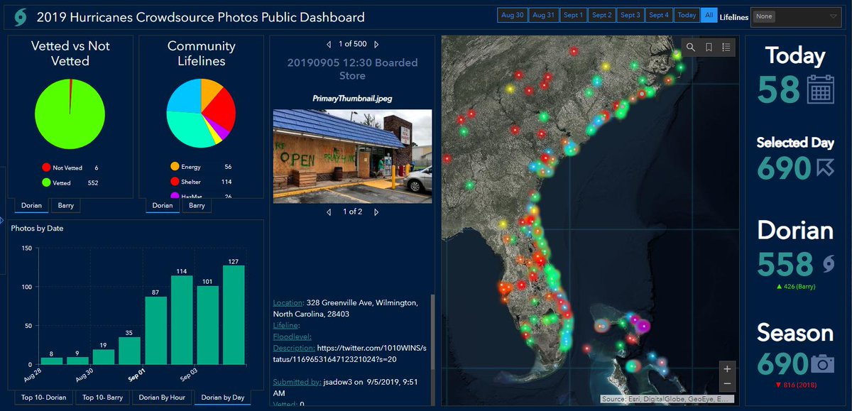
GISCorps volunteers are mapping crowdsourced photos of Hurricane #Dorian: arcg.is/0Hj1XD. Filter the photos by FEMA Community Lifeline or date on our operations dashboard: arcg.is/0zLTeW0 #disastermanagement #GIS @napsgfoundation @CEDRdigital


New to #GIS? This (free) Esri learning plan is designed for you. Learn GIS fundamentals & start making #maps today → esri.social/b0jp50Ptgl8

Here's our top-rated @ArcGISOnline course to help you get started with web #maps and #apps. ☁️🗺️ View details & class dates: esri.social/vmYY50PsmJv


Happy to help announce @Dataminr 's new crisis response program for nonprofit groups! Very fitting as later today I'm giving a talk at the @napsgfoundation INSPIRE conference on how Dataminr's AI is used for crisis response. #aiforgood #dataminr
Dataminr has expanded its social good efforts with a new Crisis Response program created to support nonprofits on the front lines of emergency response operations. Learn more: hubs.li/Q01qKrBz0
I had a blast at #InSPIRE 2022!!!! Thank you to @napsgfoundation for putting on a great conference!!! #InSPIREtheMap

A big thank you to the @napsgfoundation staff and board for a successful #stillwater #inSPIREthemap event for 2022. #osu

It was a privilege for me to represent all of @CEDRdigital's dedicated volunteers and accept this award on their behalf at #InspireTheMap! Congratulations and thanks to our partners (and friends) at @GISCorps and @napsgfoundation !
GISCorps and @CEDRdigital received the @napsgfoundation 2022 Award for Excellence in Public Safety GIS in recognition of the PhotoMapper team's work geolocating photos during national disasters. Thank you to all of our PhotoMapper volunteers for your commitment to #GISforGood!

Thank You to the @napsgfoundation, @GISCorps, @CEDRdigital, & others, & those that helped make it possible for me to attend InSPIRE 2022! I learned so much, met amazing people, collaborated on an exercise, and more! It was wonderful and amazing! #InSPIREtheMap #GISforGood
Learning about the difference between cognitive maps and differences between our typical data driven GIS maps #InspireTheMap


Having GIS FOMO? Registration is still open for #gisPro2022! Visit the URISA site to register today: buff.ly/2Y0m7ye. We can't wait to see you there! #geospatial #gis #youngprofessionals


Kevin Kay from @napsgfoundation discussing GIS standards @IAFC #FireDataAnalysis

Great discussion by Kevin Kay of @napsgfoundation on the importance of standardized symbology and user interface.

When you realize that we are one month away! 💃 esri.social/EyGO50JqFwC #EsriUC
July 12-14, UT-TF1 hosted a Tech Search Specialist class with 36 members attending from 14 task force teams across the nation


I had the opportunity to speak at the 2022 ESRI User Conference today about how we can better tackle the climate crisis by building community resilience. Geospatial tools are key to identifying risk and helping us plan for future disasters. Thank you for having me! #EsriUC


Collaboration and coordination during blue skies is the theme from @napsgfoundation @TVFR @TigardOR at the Disaster/Emergency Management SIG. #EsriUC

Sparky the fire dog is ready for family night @ #EsriUC! Stop by the #PublicSafety neighborhood (Exhibit hall B1) to meet him!

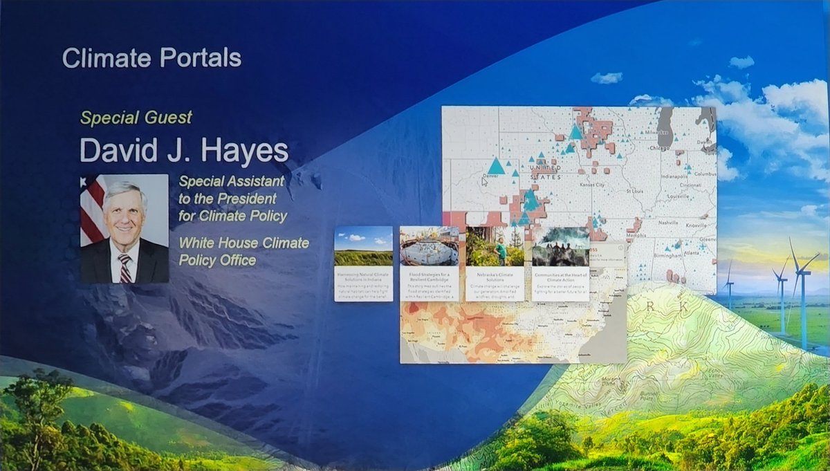
Great to hear from David Hayes, Special Assistant to the President for #Climate Policy. He believes in the value of #GIS to make improvements and prioritize #equity . #esriUC #HealthGIS

Trends for United States
You might like