Esri Disaster Response Program @EsriDRP
Esri's DRP assists with disasters worldwide. We support response and relief efforts with GIS technology and expertise when your capacity is exceeded. esri.com/disaster Redlands, CA Joined June 2013-
Tweets1K
-
Followers4K
-
Following210
-
Likes786
When Fort Lauderdale was hit by a deluge that caused substantial damage, mapping the damage helped city responders secure funds to restore the city quickly. Read More: esri.social/cuZ850RhswM

When Fort Lauderdale was hit by a deluge that caused substantial damage, mapping the damage helped city responders secure funds to restore the city quickly. Read More: esri.social/cuZ850RhswM

When Fort Lauderdale was hit by a deluge that caused substantial damage, mapping the damage helped city responders secure funds to restore the city quickly. Read More: esri.social/cuZ850RhswM

Discover how the City of Rochester Hills, Michigan, streamlined delivery of fire education and resources to the community with our survey management solution. Find out more: esri.social/178n50RhoE0

In the wake of devastating wildfires, the need for effective evacuation planning has never been more urgent. Leveraging the latest technologies to revolutionize evacuation planning and execution is key. Read our blog for more information: esri.social/xgtE50RhqV8

To offer users greater flexibility and improve performance, the latest release of Daily Activity Dashboard now includes separate dashboards for crime and calls for service. Find out more: esri.social/u8r150QQBUL

Brazil's National Wildfire Information System (Sisfogo) makes it simple for firefighters to collect wildfire information and incident details, which are displayed on a dashboard for decision-makers. Read our blog for more: esri.social/LZ5550QQzFR

Learn how urban conflagrations require new levels of information sharing and collaboration among emergency managers, firefighters, and wildland firefighters. Find out more: esri.social/ynvr50QQAIm

To offer users greater flexibility and improve performance, the latest release of Daily Activity Dashboard now includes separate dashboards for crime and calls for service. Find out more: esri.social/1MPO50QQBTN

To offer users greater flexibility and improve performance, the latest release of Daily Activity Dashboard now includes separate dashboards for crime and calls for service. Find out more: esri.social/p9CL50QQEL7

Brazil's National Wildfire Information System (Sisfogo) makes it simple for firefighters to collect wildfire information and incident details, which are displayed on a dashboard for decision-makers. Read our blog for more: esri.social/hAt250QQzwv

Brazil's National Wildfire Information System (Sisfogo) makes it simple for firefighters to collect wildfire information and incident details, which are displayed on a dashboard for decision-makers. Read our blog for more: esri.social/YyKe50QQExF

Learn how urban conflagrations require new levels of information sharing and collaboration among emergency managers, firefighters, and wildland firefighters. Find out more: esri.social/fKXE50QQAnB

During a disaster event, rapid response is critical. For Vermont residents who experienced flooding in July 2023, disaster response meant receiving relief sooner instead of later—thanks to GIS and drones. Read our blog for more: esri.social/AgZ550QQxk2

During a disaster event, rapid response is critical. For Vermont residents who experienced flooding in July 2023, disaster response meant receiving relief sooner instead of later—thanks to GIS and drones. Read our blog for more: esri.social/mzQW50QQvRO

During a disaster event, rapid response is critical. For Vermont residents who experienced flooding in July 2023, disaster response meant receiving relief sooner instead of later—thanks to GIS and drones. Read our blog for more: esri.social/AgZ550QQxk2

Learn how urban conflagrations require new levels of information sharing and collaboration among emergency managers, firefighters, and wildland firefighters. Find out more: esri.social/7gam50QQAye

Fieldwork in every industry has one thing in common: Location 📍 No matter where you work, Fieldwork Handbook is your friend in the field. This guide walks you through preparation, equipment considerations, and streamlining your data. Learn more: esri.social/fleG50QY64i


Dr. Dawn Wright + @de.. @deepseadawn
23K Followers 958 Following Aquanaut + Chief Scientist of @Esri + @OregonState GIS/oceans professor, cyclist, 1st Black diver to #ChallengerDeep, builds w/LEGO, raised in Hawaii.
🥔🗺️ ᴘᴏᴋ.. @pokateo_maps
25K Followers 3K Following 👋🏻 I'm Kate ᵉᵃᵗᵉʳ ᵒᶠ ᵖᵒᵗᵃᵗᵒᵉˢ ᵃⁿᵈ ᵐᵃᵏᵉʳ ᵒᶠ ᵐᵃᵖˢ 🌐 I make #geospatial & #GIS (more) fun by sharing #mappymeme s & #maptastic themes. Hosts #GISchat. ᵛᶦᵉʷˢᵐᶦⁿᵉ
Esri @Esri
193K Followers 70K Following Esri builds #ArcGIS, the leading location intelligence and spatial analytics software for mapping, 3D GIS, imagery, and geospatial app development.
josephkerski @josephkerski
14K Followers 2K Following Geography, geo-geekiness, STEM, ed tech, space, place, geographic information systems (GIS), GPS, outdoor education 365 days a year.
Derek Law @GIS_Bandit
6K Followers 1K Following Product Manager @Esri | Interests #GIS, #HealthGIS, #Maps, #DataViz Bluesky: https://t.co/wQd6s7i22E Comments are my own.
Qiusheng Wu @giswqs
38K Followers 5K Following Associate Professor @UTKGeography | @Amazon Visiting Academic | Senior Reseach Fellow @UNUINWEH | #EarthEngine GDE | Talk about #opensource #geospatial #dataviz
Esri Training @EsriTraining
33K Followers 1K Following Advancing geospatial capabilities of individuals, teams, and organizations is our mission and our passion.
P.J. Doherty @pjdohertygis
4K Followers 4K Following Supporting search and rescue teams with geospatial tools. All opinions are my own, not representing my employer. #SAR #publicsafetygis #GIS
ArcGIS StoryMaps @ArcGISStoryMaps
31K Followers 964 Following ArcGIS StoryMaps helps you tell remarkable stories with custom maps that inform and inspire. Join our growing storytelling community.

ArcGIS Survey123 @ArcGISSurvey123
8K Followers 373 Following Smarter forms, smarter decisions! Included with ArcGIS.
Wanmei L 🌎🛰️ @MapsbyW
3K Followers 303 Following Science Data Visualizer at NASA 🌎 🛰️ 🗺️ | UCLA Alumni 🎓 | Visual Storyteller 📚 | Cartographer 🧭
Esri Public Safety @GISPublicSafety
11K Followers 4K Following Discover the power of ArcGIS to manage emergencies and the flow of public information.
NAPSG Foundation @napsgfoundation
2K Followers 895 Following #Nonprofit dedicated to building the #publicsafety community's #geospatial #technology capability & providing #GIS subject matter expertise.
URISA's GISCorps @GISCorps
4K Followers 2K Following Operating under the auspices of URISA, GISCorps coordinates short-term, volunteer-based GIS services to communities in need worldwide.
Krista West, Ph.D. @RSFireNerd
4K Followers 4K Following Pyrogeographer. #RemoteSensing of Wildfire. 🛰🛩🔥 | Passionate about finding ways to help first responders 👩💻❤️🚒
Adam Carnow @SpatialAce
3K Followers 3K Following Public Works Industry Specialist @Esri. Opinions are mine. Bottom line: I help people make better decisions with the power of location. https://t.co/vHWEFg5b5v


Zach Stanford @zachstanford
2K Followers 4K Following Emergency Management & Homeland Security | Risk & Hazard Comms + Maps | Cares too much about emergency alerts | Opinions = mine | ENTP | WX5OEM | #EMGTwitter
Thunder @J1u422fhU6v14
51 Followers 1K Following I am a lively and cheerful girl who would like to meet a good friend.
Agnes Abang @abangagnes1
17 Followers 286 Following
Fahad Alahmadi @FahadAhmadi
20 Followers 153 Following
Cengiz Yıldırım @cengizgeomorph
1K Followers 727 Following Prof. Dr. - İTÜ Avrasya Yer Bilimleri Enst.

Rat Race in Manhattan.. @TatsuyaSekan
357 Followers 5K Following CHD SIT U of Alabama Civil Eng. Henan Exodus. MicrosoftBoo. Research interest: OR GIS CSS ABM RL
Haoussa Hamza @hamza_haoussa
22 Followers 324 Following
Gabriel LEJEUNE @gabriel_lejeune
25 Followers 800 Following
Patel D K @DrshtapUs
3 Followers 90 Following

ROK Technologies @roktech
341 Followers 486 Following 75+ years experience architecting, deploying, managing cloud, hybrid & on-premise GIS solutions: ArcGIS Cloud Services, GIS Managed Services, Virtual Desktops.
Dauphin County DPS @DauphinDPS
795 Followers 155 Following Providing citizens with assistance across the total realm of emergency management
Ahmed Helmy @ahmedhelmyumar
171 Followers 1K Following خبير وعاشق لنظم المعلومات الجيومكانية، ومحب لمشاركة المعرفة
Abdollahzadeh @miraje2012
39 Followers 141 Following پژوهشگر دکتری شهرسازی phd candidate urban regional planning
Genasys Inc @GenasysInc
1K Followers 2K Following The global provider of Protective Communications Solutions.
Martin Periu @Martinperiu6
883 Followers 4K Following Maga, Animal lover, Always looking for good recommendations, Entrepreneur, Life Coach.
Tom @kiwits
34 Followers 131 Following Background in environmental management and the application of geospatial mapping and analysis technologies in the oil and gas sector.
Fulcrum @fulcrumapp
3K Followers 2K Following Fulcrum is an industrial-strength, geospatially focused field data collection and process management platform. Please visit us at https://t.co/Xps0JPrqvG.
Angel @Angelihass
8 Followers 154 Following
Music Saves Lives @MusicSavesLives
23K Followers 5K Following Saving Lives Never Sounded So Good™. https://t.co/vjxa2fkdfz https://t.co/3ZMzvJdDnk
Nuha aldaoud @N_Aldaoud
4 Followers 54 Following
Matt Kearney, CEM @MKearneyEM
90 Followers 189 Following Director of Operations & Special Projects for @AlertBoston | MBA from @BUQuestrom
mariângela martins @mari_poser
28 Followers 121 Following

yuyu @NwwYuanyuam
193 Followers 547 Following water resources engineer in canada,Hec-ras,gis ,cad user
Oscar 🇷🇼 @oscar1716
588 Followers 2K Following I did BSc. Chemistry and Dipl. in Waste and Drinking Water Treatment. Curator & Herpetologist @RwandaMuseums. I❤️Environment, Culture, Science and Technology

black diamond @EmperorHajo
2K Followers 2K Following Fashion enthusiast |Rebel🚦 |Town planner |Normal = boring |Not regular | 😍 canine | #GGMU
PAUL ADEBISI @PAULOADEBISI
78 Followers 507 Following Student || computer technician || Gis || wordpress || member @youthmapperfuta

M U K I @bwanamuki
562 Followers 362 Following Accidental Geographer 🌍 Geospatial enthusiast | Sports | Politics


Benedict @benedikkt_
332 Followers 1K Following Surveyor | Geospatial Data Engineer | Renegade^-1 I know Nothing
Asiwaju of the source @bodalatv2
230 Followers 318 Following Students Surveyor | Senator @UnilorinSc | PROGRESSIVE since foetus | Rotaractor
Tobi.Tech (TT) @Tobi_vibez
316 Followers 692 Following Software engineering @ALX || UI Expert with Figma || Web Developer with HTML,CSS,JAVASCRIPT
Adebowale @ajagbeabeeb
1K Followers 2K Following DAAD scholar 🇩🇪/Climate analyst @advokcng/ (MSc Geography of environmental risk and human security) @UNUEHS & @UNIBONN🇩🇪/ GIS & RS /EIA /GREAT IFE


Clinton Nwokocha🐍 @OdogwuGuyman
3K Followers 5K Following Under the influence of Data|SQL|Excel|Power BI|Python|GIS/QGIS enthusiast| Lead Ambassador I4G
JUFEDURA @jufedura
113 Followers 1K Following
Daniel Donkor @ddonkor209
6 Followers 126 Following
Arunachalam MAK @ArunachalamMAK
11 Followers 295 Following
Samet Karış @s_kar3118
0 Followers 769 Following
Paolo Tozzi @Owl1963
44 Followers 312 Following
Franz Schreiber @geokaiser_
717 Followers 1K Following #Geógrafo #Geograph #Geographer #Géographe #Geograaf #Geographum
telugubidda outside t.. @boredom1335
13 Followers 93 Following Have a look into https://t.co/RjdStyU5tl
nicou @nicolasfierrov
15 Followers 333 Following
Stephen Ansari @sansari22
183 Followers 253 Following
Esri @Esri
193K Followers 70K Following Esri builds #ArcGIS, the leading location intelligence and spatial analytics software for mapping, 3D GIS, imagery, and geospatial app development.
Derek Law @GIS_Bandit
6K Followers 1K Following Product Manager @Esri | Interests #GIS, #HealthGIS, #Maps, #DataViz Bluesky: https://t.co/wQd6s7i22E Comments are my own.
michael GOULD (@mgoul.. @0mgould
11K Followers 3K Following GIS professor and Global Education Manager at Esri (opinions my own). #travel #mountainbike #internationalDev #GIS #Spain #sarcasm
Esri Training @EsriTraining
33K Followers 1K Following Advancing geospatial capabilities of individuals, teams, and organizations is our mission and our passion.
P.J. Doherty @pjdohertygis
4K Followers 4K Following Supporting search and rescue teams with geospatial tools. All opinions are my own, not representing my employer. #SAR #publicsafetygis #GIS
ArcGIS StoryMaps @ArcGISStoryMaps
31K Followers 964 Following ArcGIS StoryMaps helps you tell remarkable stories with custom maps that inform and inspire. Join our growing storytelling community.
Esri Public Safety @GISPublicSafety
11K Followers 4K Following Discover the power of ArcGIS to manage emergencies and the flow of public information.
URISA's GISCorps @GISCorps
4K Followers 2K Following Operating under the auspices of URISA, GISCorps coordinates short-term, volunteer-based GIS services to communities in need worldwide.
Krista West, Ph.D. @RSFireNerd
4K Followers 4K Following Pyrogeographer. #RemoteSensing of Wildfire. 🛰🛩🔥 | Passionate about finding ways to help first responders 👩💻❤️🚒
Adam Carnow @SpatialAce
3K Followers 3K Following Public Works Industry Specialist @Esri. Opinions are mine. Bottom line: I help people make better decisions with the power of location. https://t.co/vHWEFg5b5v
Humanitarian OpenStre.. @hotosm
29K Followers 3K Following 🗺️ Global Humanitarian OpenStreetMap Team. #OSM for humanitarian response and community-led development.
Damian @spangrud
2K Followers 2K Following Family+ Maps + Food + Kites = me Director @ Esri and spatial geek (he/him)
Esri Blog @EsriBlog
10K Followers 4K Following Better Vision. Better World. The Esri Blog uncovers the many ways that GIS improves our world.
California Governor's.. @Cal_OES
124K Followers 2K Following Cal OES serves as the state’s leadership hub during all major emergencies and disasters.
NASA Landsat @NASA_Landsat
80K Followers 470 Following The NASA/USGS Landsat series of Earth-observing satellites has monitored our planet for over 50 years. Verification: https://t.co/4p9BhINXeQ
Esri Startup Program @EsriStartups
13K Followers 9K Following Growing #Startups. Official #Esri Startup Program Account. Check out our site for program details. Follow the buzz @EsriStartups
carmelle terborgh @geotellus
838 Followers 801 Following Mom to 2 boys | Geographer | Lead Account Manager, Global Organizations at Esri | Essex Junction Lions Club | views are my own
Agendra Kumar @agendra
205 Followers 57 Following Managing Director - Esri India, Past President - Association of Geospatial Industries. Nature and heritage photographer.

OregonOEM @OregonOEM
24K Followers 1K Following The official page of the Oregon Department of Emergency Management.
Santa Barbara County @countyofsb
24K Followers 456 Following Official Santa Barbara County government Twitter site. En español: @csbenespanol
CaliforniaDisasters @CalDisasters
6K Followers 1K Following On https://t.co/SmHH56qgbx WX/Geo/Fire/Disaster/History Buff/CERT/Rockhound.
German Whitley @Mgermancvo
246 Followers 1K Following https://t.co/7mwLgl9TOq, Wildfire GIS, Hydrologist, Nerd, CERT member, #FireMappers, #PhotoMappers

Jordan Cullen @JCullenNow
2K Followers 524 Following Product marketing in tech 💻 | @USArmy GWOT Vet 🪖 | @UCRiverside & @USC alumnus ✏️ | Tweets about veterans, military, business, mental health, etc.
Nordic Geospatial �.. @nordicgeo
4K Followers 5K Following Danish Refugee Council 🇩🇰 DEEP - Humanitarian AI / OpenData / GIS / ICT's & @WHO Advisor - RT does not = an endorsement.
Nikki Golding @goldingnik
295 Followers 204 Following Former Tweep, lover of music and seeker of fun |(she/her) #freebird 🌴🧘♀️
Dr. Jeff Stern @SternJD
2K Followers 713 Following 10th Superintendent @FEMA_EMI | adjunct professor @Georgetown | former @VDEM | follows/likes/retweets ≠ endorsement | Follow @FEMAspox for official info
GEO Jobe @GEOjobeGIS
4K Followers 1K Following GEOspatial company, Esri partner providing GIS solutions & UAV tech. Developer of Admin Tools, Clean My Org, Mapfolio, GEOpowered Cloud for #ArcGISOnline
Oyemakinde @seun_oye
679 Followers 2K Following GIS & Remote Sensing Analyst / A2 C of C Certified Remote Pilot.
Adam Ziegler @heyman4923
55 Followers 298 Following Esri Solution Engineer by day, home brewer by nights and weekends. Tweets are my own.
Edward G. Klein Jr. @ParaHeloBio1
201 Followers 1K Following Retired US Army Warrant Officer. Strategic Planning in a Joint Combined Special Operational Environment. Operational Research Systems Analyst / GIS Infosys
Kate @katesoup63
744 Followers 4K Following (she/her) geographer • cartophile • TCK🇺🇸🇮🇳 • history nerd 🤓 • end the stigma 🧠💊 • period drama fangirl • beer nerd wannabe 🍺 #GetVaccinated
Esri Business Team @EsriBizTeam
3K Followers 1K Following We offer strategic software solutions for business, insurance, retail, financial services, real estate, manufacturing, and media customers. #EsriBizCommunity
Blue Raster @blueraster
3K Followers 2K Following We've been building award winning, interactive web mapping applications since 2002. We specialize in @Esri #ArcGIS & Mobile Apps. 🌎 #LocationIntelligence #GIS
Jenna Lee 😷 🇺�.. @origamikitti
47K Followers 52K Following engineering & law school grad .. #catsoftwitter😻 #adoptdontshop🐶 #carfree🛴 .. #ubi - championed by MLK Jr & #yanggang 🧢 .. #blacklivesmatter 🌈ally ♿a11y
Este Geraghty @EsteGeraghty
2K Followers 2K Following Chief Medical Officer and Health Solutions Director at Esri (Opinions expressed are my own)
Global Forest Watch @globalforests
28K Followers 3K Following #GFW10. Global Forest Watch provides the best available data and user-driven tools for monitoring forests. It's free and easy-to-use. Led by @WorldResources.
Gabriele Nicolò @GabbroGIS
161 Followers 470 Following GIS 2D&3D, GeoSpatial Analysis, Remote Sensing, Geomatics, Python, Environment, Natural Hazards. Employed @ an environ. protection agency. Opinions are mine.
🇵🇹Common Raven�.. @Bewickwren
12K Followers 9K Following Wx spotter; community emergency; wildfire; nature observer; dog rescue... Languages: português | español | français | русский
Jenn Stewart @jenndbic
274 Followers 495 Following RV Life, kayaking, snowbirds that love our winter home in Yuma, love nature, traveling and exploring, worked BC Parks, proud Mom and grandma, love ❤️ my hubby
JJ the Santa Barbaria.. @cookiesinheaven
5K Followers 5K Following Swiller of lattes, hugger of trees, #cookie inhaler of Finnish descent At the M place - @[email protected] FAIR WARNING: I tweet a bunch
Alana Baker @abakerGIS
304 Followers 185 Following GeoGEEK and Map enthusiast. GIS Consultant for the National Capital Region @EsriCanada #GISAmbassador. *opinions are my own
Ryan R. Bart @ryanrbart
483 Followers 705 Following Disturbance ecohydrologist at UC Merced. I'm no longer actively using Twitter. You can find me now at Bluesky. https://t.co/BPDQiORRg3.
Robert C. Sheldon @RobertCSheldon
122 Followers 218 Following Dad, photographer, Photoshop Pro, bass guitarist, keyboardist
Jeremy Wright @inertcatnip
906 Followers 595 Following Product Engineer, Esri -- opinions are my own, not my employer's.
Crystal-lee🦉 @tea4tillermen
651 Followers 436 Following Makeup Artist, Film Editor, Graphic Designer, Award Winning Lesbian and Pathological Upstager. Happily Gay Married. Dolly Parton loves my skin.
Susan Minnemeyer @susanminnemeyer
522 Followers 1K Following Interested in all things conservation, restoration, forests, climate and natural climate solutions

Edie Punt @epunt
3K Followers 109 Following cartography product engineer and writer at esri. runner, retired coxswain, fibre artist.🪡 🗺, she/her.
David A. Clarke, Jr. @SheriffClarke
859K Followers 260 Following Retired Sheriff of Milwaukee County, President of Rise Up Wisconsin INC, Board of Directors at the Crime Research Center, Author of the book “Cop Under Fire”

James Woods @RealJamesWoods
3.9M Followers 5K Following
Larry Elder @larryelder
1.6M Followers 468 Following We’ve got a country to save! Subscribe to my Freedom Chat channel. New book: “As Goes California—My Mission to Rescue the Golden State and Save the Nation”
Mark R. Levin @marklevinshow
4.0M Followers 5 Following THIS IS THE OFFICIAL MARK LEVIN SHOW X PAGE. DOWNLOAD MY PODCAST FOR FREE https://t.co/LbO9BeMtMZ Join me at https://t.co/ARrBQZKtMb
Hugh Hewitt @hughhewitt
206K Followers 2K Following Syndicated Radio Host 6-9 AM EST on Salem Media and network affiliates nationwide. Washington Post contributing columnist. Browns/Tribe/Cavs/Buckeyes
What is GIS? @GISdotcom
24K Followers 16K Following GIS lets us visualize, question, analyze, interpret, & understand data to reveal relationships, patterns, & trends.
Ben Shapiro @benshapiro
6.7M Followers 378 Following Daily Wire co-founder, host of @benshapiroshow, #1 NYT bestselling author, America’s #1 ex-rapper
Dennis Prager @DennisPrager
349K Followers 328 Following Dennis Prager Radio Show. Founder of @PragerU. NYT best-selling author. Columnist. Orchestra conductor. Author of The Rational Bible. Co-star of #NoSafeSpaces.
Monde Geospatial @MondeGeospatial
11K Followers 3K Following Geospatial videos, news, articles and events relating to #GIS, #cartography, #RemoteSensing, #GPS, #Surveying, #Geomatics and #geospatial technologies
GIS Cloud @GISCloud
18K Followers 3K Following Operating on the fastest map engine available, we offer cloud-based GIS solutions for data collection, sharing, collaboration and publishing: [email protected]
PragerU @prageru
989K Followers 972 Following PragerU creates educational content promoting American values. Download our app and watch more at https://t.co/3QSteHUg7S. Think better. Live better.
Adventure Scientists @AdvScientists
11K Followers 2K Following We amplify the impact of environmental and human health researchers by training outdoor adventurers to collect high quality data from around the world!Get the latest information on #HurricaneHilary. Explore live interactive maps and find resources from @EsriDRP to support your response efforts. esri.social/gF7k50PACgp

When disaster strikes, volunteer aviators take to the sky to collect imagery for recovery efforts. Meet Capt. Scott Kaplan, a volunteer with @CivilAirPatrol, an organization that’s helping millions. esri.social/hJSh50Ofc7H #DisasterResponse @WPCreativeGroup

Discover how #GIS technology was combined with #AI to leverage disaster response after the events of Hurricane Ian, allowing emergency responders to connect with those in need of help. ow.ly/HzHQ50PmVEL

✨CASE STUDY✨Discover how Placer County CA created an award-winning #GIS dashboard to improve emergency communications: arcg.is/14TOvq1 @PlacerCA @EsriDRP @EsriSLGov #ArcGIS #emergencycomms #localgovernment #ReadyPlacer


Bravo 👏 @UNopenGIS @UNOSAT @EsriDRP @RyanLanclos @CottrayOlivier @geotellus as @PDC_Global will be there 👏 🌎 🛰️ 🇨🇭 PS here’s a teaser 🛰️🛰️ 🌊 & bravo 👏 Dr @Shanna_McClain @NASAEarth @disasteraware pdc.org/nasa-pdc-flood… youtube.com/watch?v=fpllbc… @UNITAR @Esri 🗺️ 🇨🇭
Don’t forget to register for the GIS for a Sustainable World Conference! Network with colleagues, technical experts, solution providers, and other peers to explore best practices and share innovative ideas. Register: esri.social/BwWB50N4cK6 #GIS4SW #SustainableWorld #GIS4SDGs


Join AfP's L&E team on Wed, 12/1 at 10:15am ET as they contribute to a discussion on advancing the use of GIS in peacebuilding, as part of a workshop on emerging technologies in peacebuilding & prevention organized by @nyuCIC! #data4peace Register: dataforpeace.conference.tc/catalog/tech-i…


Excited to continue the work of organizing our #GIS #EM community. Today, we've released a new #Hub site to help our partners stay informed with initiatives and planning for the future. See it here: prepfit-geo.hub.arcgis.com @EsriDRP @EsriSLGov @ArcGISHub @GISPublicSafety
In the aftermath of the 9/11 attacks, #mapping tools wielded by a dedicated team of #GIS professionals were a crucial part of the #disaster response & recovery process in New York City ow.ly/mESO50G9fBJ #Esri #ArcGIS #IAEM #govtech #statelocalIT #emergencymanagement #map

This Oil Spill Hub site from @EsriDRP is actively monitoring the oil spill in California. Find ready-to-use apps that immediately aid better understanding and decision-making around the response. …spill-disasterresponse.hub.arcgis.com #ArcGISHub #SoCalOilSpill #disasterresponse


#Crowdsourced #damageassessment reports helped the Oklahoma Department of Emergency Management (OEM) speed up recovery after the 2019 floods. Read how: bit.ly/308r7li


Retweet - Esri: RT @EsriDRP: .@EsriDRP is actively monitoring the oil spill in California. To request immediate #GIS assistance, visit esri.com/disaster. Additional resources can be found at the Oil Spill Hub: …spill-disasterresponse.hub.arcgis.com #SoCalOilSpill #disasterresponse

Today is an exciting day! We announce the launch of our Data Hub, an online repository for GRID3 #data. Visit: data.grid3.org (1/5)

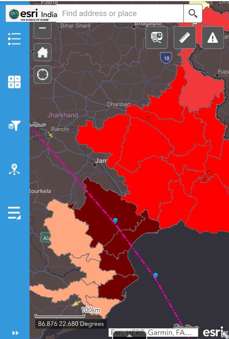
Within 2 days the map has been viewed by over 200,000 people. @EsriDRP team is always there to support the users & community in any emergency with resources, maps, and data to be better prepared to tackle such situations. #YaasCyclone @ndmaindia @NDRFHQ @IMDWeather @IndiaDST

Get an integrated view on the movement and impact of Cyclone Yaas on Esri India GIS map. Built with #ArcGIS. RT to spread the word Track Yaas Cyclone - bit.ly/3vqgEMY #CycloneYaas #Esri #GISMap #Cyclone #OdishaFightsYaas

ICYMI: We've added additional spots to the virtual event we're co-hosting with our friends at Geoawesomeness! Join us for this interactive opportunity to hear from leading #EmergencyManagement & #GIS experts. Register here ➡️ my.demio.com/ref/f00LQ31mlT… #EMGTwitter #SMEM

Join Esri subject matter experts with special guests, @pjdohertygis and @napsgfoundation's Jarod Doke for the 2nd installment of the #IMT webinar series! See how GIS solutions can support the operations section during IMT incident response. Register: go.esri.com/IMT-web2-tw

Last chance to join us for a webinar for #IMT personnel! See how GIS solutions can help maintain a common operating picture, evaluate and share information, track resources, and identify safety hazards. Learn more and register for the webinar series: ow.ly/JZ4150DLasX

Thank you for highlighting the work of GISCorps volunteers, @EsriPress! We are proud to have been able to contribute to pandemic response in partnership with @EsriDRP.


Always inspired by #geospatial innovations of @CottrayOlivier & life-saving work of @EsriDRP @jeffbaranyi @RyanLanclos @Esri_Nonprofit @geotellus @GISPublicSafety 🗺 esri.com/videos/watch?v… esri.com/en-us/disaster… From @WFP to @iMMAP_org to @theGICHD, Olivier is a #legend 🌎


After a 5.5 earthquake hits Croatia, #ArcGIS and @EsriDRP aid the city of Zagreb with technology to assist damage assessments and recovery. ow.ly/PtLh50BbjCj #EsriDRP #disasterresponse #disasterassistance #GDi #zagreb

New conflagration for fire activity from #MosierCreekFire. Check out location information on our #LeadershipBriefing #app here: experience.arcgis.com/experience/9bb… @GISPublicSafety @EsriDRP @EsriSLGov @OregonOEM

Trends for United States
You might like