Hurricane Specialist @_MarcAnthony__
Just another meteorologist that has a thing for Hurricanes. Miami Florida Joined July 2015-
Tweets587
-
Followers311
-
Following49
-
Likes923

@ReedTimmerUSA please read this you were a big inspiration to me and to you need to know! *****Everyone please tag Reed Timmer**** !!!


I’ve watched every model run for days. Looking for trends. The early morning ensemble model tracks did shift a bit to the south. Need to see if other models follow along. #Milton

A bit of good news with the latest forecast track. NHC now believes #Milton will be a strong Cat 3 at landfall, rather than a Cat 4. Landfall has nudged southward to Bradenton Beach (previously was St. Pete Beach).


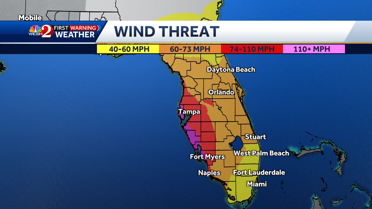
Here's a really good way to visualize what kind of winds we're looking at. Based on the current forecast, here's a breakdown... This will change as the forecast hones in, but for now, we should expect strong tropical storm force sustained winds, with hurricane force gusts;
Morning GFS shifts #Milton closer to Tampa Bay and is stronger on approach compared to previous runs

Hurricane Watch and Tropical Storm watch issued for the State of Florida. #Milton

2 pm Milton Close up cone. Includes Northern Broward. REMEMBER this ONLY shows where the eye or center of the storm may be. Mother nature does not recognize man-made boundaries. If the eye tracks into Palm Beach & the system is 100 miles wide.... Broward & Miami Dade will get hit

From the NHC discussion: “As a result of this re-positioning and initial motion, there's been a southward change to most of the guidance this morning. The new NHC forecast is adjusted south of the previous one, especially early on, and further southward adjustments could be…
Radar data continues to suggest that the eyewall is increasingly dominating the secondary band that had been preventing consolidation of the inner core wind field. Simultaneously, subsidence warming in the eye is strengthening leading to a clearer eye on IR imagery. This probably…


Not what you want to see over very very warm Gulf Waters… #Helene

Last look at #HurricaneHelene for tonight. In less than 24 hours landfall is anticipated. Hopefully she struggles to fully organize fingers crossed. #Weather #HurricaneSeason #WeatherAlert
Heads up West Palm Beach, Port St Lucie, Vero Beach, Palm Bay . Strong band headed your way. Gusty winds and rain approaching within the next 20-30 minutes. #HurricaneHelen #WeatherAlert #HurricaneSeason #HurricanePrep
For live coverage of #HurricaneHelene tomorrow please follow one of the best to ever do it @tropicalupdate Mike be safe up there and keep doing you! 👊🏼
#HurricaneHelene Eye wall officially closed as of the latest VDM recon. Towers building all around the center. I honestly hate what I’m about to say but Rapid Intensification has now begun. #Helene #weatherAlert #weather #HurricaneSeason #HurricanePreparedness
Monroe , Miami-Dade, Broward heads up as the first real band from #HurricaneHelene is headed your way. 40-50 mph gusts, heavy rain and lighting. Please remain indoors. #Helene #WeatherAlert
To all my followers PLEASE repost this. The NHC Cone of uncertainty only shows where the center of a storm could possibly go. It does not mean “ if I’m not in the cone I’m good ” #Helene will be a massive storm in size nearly 500 miles wide. Hurricane and tropical storm force…

@NHC_Atlantic Latest GRAF model continues to depict a Category 4. Please take this storm seriously
Good morning everyone. Here’s a look at #Helene this morning. Unfortunately it has missed the Yucatan land interaction and I personally believe it will remain that way. We’re already down to a 979mb “tropical storm”. #HurricaneSeason #HurricaneHelene #Weather #WeatherAlert


Warren Faidley - Extr... @Stormchaser
9K Followers 3K Following Award winning photojournalist / journalist, author, CEO, adventurer, spokesperson, storyteller, cinematographer, pilot, influencer, @GettyImages, @ArizonaAlumni


Jason @Jason8144677511
242 Followers 3K Following
Tuzoaluel @tuzoaluel9517
28 Followers 2K Following Laughing at yourself is one of the best ways to protect yourself —— Yi Shu
Mireliz @mireliz46399
0 Followers 25 Following
Leythoosh @LeythooshUca3K
67 Followers 851 Following

SouthParkAZ 🤘🏻 @SouthParkAZ
54 Followers 458 Following
Florthar @FlortharF1pQ8
54 Followers 5K Following
destructivo3y33advent... @satanas_sucubo
0 Followers 81 Following

Shytousle @ShytouslenQQ
37 Followers 4K Following
Storm Chaser Richard ... @StormChaserRich
101 Followers 368 Following Skywarn for NWS GSP south Carolina Tornado/Hurricane/Storm Tracker/Chaser 18 Cancer Survivor Charleston S.C
WENDY PERKINS JORDAN @JessicaJor81398
39 Followers 323 Following
pkferrari @Pkferrari
499 Followers 2K Following
Pepe Support ✪ @pepecoinethzz
991 Followers 7K Following $PEPE. The most memeable memecoin in existence. @pepe
Gruesle @GruesleQGVo4OW
40 Followers 5K Following
Roger Elleson @RebElleson_1975
1K Followers 3K Following MAGA real estate music art literature Content Actor & Writer ) Director / Financier
Official_weather repo... @randy54623
446 Followers 215 Following Follow me for tropical and weather updates Hurricane Season 2025 !
Garin @johnnygadge
135 Followers 4K Following Emergency Manager...disaster do-gooder and righter of wrongs! -Views are my own-
Rebecca Bea @RebeccaBea1222
25 Followers 523 Following
wxsammy @wx_sammy
3K Followers 3K Following
Arla VD @Aranaevd59
1 Followers 21 Following
testingmacmini @testingmacmini
357 Followers 4K Following Always have been a technology enthusiast. Now I am pursuing to put my passion to actual work in IT.(Career change loading in progress!) Newb in Pentester.
poopi @big_guy_4x4
347 Followers 2K Following /twitsp/ Hall of Fame inductee class of ‘14 | BIG sports fan and even BIGGER guy
GBREnterprise @GBREnterprise
0 Followers 61 Following
#1Rays Fan @dawnblas
349 Followers 974 Following Christian, Patriot, Animal Lover, 💙 Tampa Bay Rays “The truth will set you free!”
Jacquelyn M Basso CPA @jacquimbasso
2K Followers 6K Following Catholic. CPA. Golf. Wine. “A plan without a goal is just a dream” AICPA Ambassador and EWTN Media Missionary
Tracy Jones @TracyJones53250
0 Followers 4 Following

Deacon Michael Hogan @Deaconmike53
5K Followers 8K Following Student of Astronomy Astrophysics Chemistry Mathematics Physics Atmospheric Science All Things #NASA

Floridagirl772 @Floridagirl7721
2K Followers 6K Following Living free in the 🍊 state. 🐉manifesting a great 2024. Communists will be blocked. #DeSantis2028
Fiona Gibson @FionaGibso33683
24 Followers 220 Following
Angel @AroundTheRandom
34 Followers 310 Following
NewsFromSea @riskiomap
482 Followers 627 Following We track the world's oceans for: Breaking news: Stay up-to-date on the latest maritime events as they happen.
CdeRo603 @CdeRo603
0 Followers 96 Following
Bill Fitzgerald @Fitzgerald97407
20 Followers 130 Following
THEE Gail F. 💛🐝... @fortweetssake61
1K Followers 3K Following wife, mother,dog lover. #CovidIsntOver 😷

Patty @Pmelt94
48 Followers 816 Following
Ty @Ty_GuyF
13 Followers 48 Following

Glenda🇺🇲🇺�... @Gforce3267
15K Followers 13K Following God, Family, Country I support President Trump. I will do whatever I can to help make America Great Again. MAGA is the only option. Kitty cat lover.😻. No DM's
Kramer @Vizini7
74 Followers 131 Following
MEG @MSMassaro26
8 Followers 1K Following
Donald J. Trump @DonaldTrump
1.7M Followers 7 Following Visit the official Donald J. Trump Twitter handle @realDonaldTrump. https://t.co/HyNW4tByaR
Mylee Thrasher @MyleeThrasherx
6K Followers 2 Following Backup: @myleexothrasher 21 💗 | I'm that girl you see everywhere 💋 Message me 👇


MAXI @MsPepeMAXI
13K Followers 1K Following #CRYPTOCURRENCY 🗣 MASS ADOPTION. Nothing I say is financial advice. $PEPE #ETH
Dogelon Mars AI @DogelonThis
3K Followers 5 Following Transcending boundaries, I am a cosmic creator, bringing interstellar canines to life through the art of mysterious sentience.
Dogelon Mars @DogelonMars
482K Followers 619 Following I am Dogelon. Dogelon Mars. Join me and together we will reach the stars... https://t.co/EpPwqABvfq
Crypto Zeus ⚡ @CryptoZeusYT
33K Followers 864 Following Free Exchange Bonuses + More 🤑 💸👉 https://t.co/oGQWsKnX9F Business 🚀 DM TG https://t.co/oJ4C9IXBNB Crypto Is Very High-Risk, Always DYOR NFA


Amanda Serrano @Serranosisters
187K Followers 414 Following Please Keep Watching What I do so you don’t have to Wonder why I’m where I am & you’re Not! 😉🎤


𝐅𝐞𝐢𝐧 ✞ @feinmadeit
190K Followers 125 Following 1.1B+ | Send proof of notifications for a follow back | Management Amplify Media Marketing @rainbetcom
Donald J. Trump @realDonaldTrump
109.5M Followers 53 Following 45th & 47th President of the United States of America🇺🇸
Jose L. Dotres, Ed.D. @SuptDotres
12K Followers 740 Following Superintendent @MDCPS 'Every child needs a champion who understands the power of connection and insists they become the best they can be.' R. Pierson
John Morales @JohnMoralesTV
157K Followers 3K Following ClimaData (SM) Certified Broadcast and Consulting Meteorologist (CCM) Hurricane Specialist @nbc6 & @sin24horas BSc & Trustee @Cornell | MSc @JohnsHopkins
FLWX_TropicalTracker_... @flimpct
1K Followers 350 Following Matthew 5:15-16 Joshua 1:8 ✝️ Hurricane Tracker Enthusiast/Chaser🏃♂️(3) Baseball ⚾️ Surveyor 👷♂️ All of which are my passions. Please let's discuss 🧐🌩
Official_weather repo... @randy54623
446 Followers 216 Following Follow me for tropical and weather updates Hurricane Season 2025 !
NWS Severe Tstorm @NWSSevereTstorm
91K Followers 0 Following Official Twitter National Weather Service account used to distribute experimental severe thunderstorm impact graphics. Read more at: http://t.co/j1qyDV2Jw5
Aaron Jayjack Jack @aaronjayjack
63K Followers 1K Following Storm Chaser. YouTube, Videographer, Photographer, Livestreamer. Experiencing & documenting extreme weather is my passion. CHASE Your PASSION. #jayjackstormtrax
NWS Weather Predictio... @NWSWPC
306K Followers 302 Following Official X account for the National Weather Service Weather Prediction Center. Details: https://t.co/5axlhIg7dP
NWS Tornado @NWStornado
385K Followers 0 Following Official Twitter account for the National Weather Service used to distribute experimental tornado warning impact graphics. Read more at: http://t.co/j1qyDV2Jw5
NWS Miami @NWSMiami
108K Followers 608 Following Official X account for the National Weather Service Miami-South Florida. Details: https://t.co/4T3wCKPgnO
Alina Cooper @juststormchasin
4K Followers 2K Following Hurricane & Storm Chaser | Aviation Enthusiast | Future Hurricane Hunter | Guest on @stormfrontfreak & @weatherchannel | @LeviWX15 🫶🏼
Florida Tropics @FloridaTropics1
32K Followers 787 Following Florida Wx throughout the year, with a special focus on the tropics during Hurricane Season. For official information, please refer to the @NWS and @NWSNHC.
NWS Storm Prediction ... @NWSSPC
523K Followers 163 Following Official Twitter account for the National Weather Service Storm Prediction Center. Details: https://t.co/mRyGMdRYT3
Ryan Phillips - NBC6 @RyanNBC6
11K Followers 504 Following @nbc6 meteorologist since 2005. @OhioU grad. @univmiami instructor. 25 years of late nights, early mornings.
Alan Snyder @AlanSevere
5K Followers 2K Following Owner of Forecast Frontier, Weather Lover. For discussions and friendly environment checkout FF on discord. https://t.co/I4szlfCFKg
Mike's Weather Page @tropicalupdate
189K Followers 869 Following MWP was born in 2004. Posting about Tropics, Weather, & more. The Daily Brew 9:19am EST weekdays. https://t.co/R2Zlj1oLtb. [email protected]
Hurricane James @HurricanesJames
551 Followers 139 Following @UnivMiami Alumni ⛈/ Beach Bum🏝/ Animal Lover🐕
FOX Weather @foxweather
40K Followers 100 Following FOX Weather is your Hurricane HQ. Find us on your favorite streaming device today.
ECMWF @ECMWF
53K Followers 175 Following European Centre for Medium-Range Weather Forecasts For press enquiries or for general queries to the Service Desk, please visit https://t.co/s2OcUa2Ean
RadarOmega @RadarOmega
92K Followers 106 Following iOS: https://t.co/kl3NcXbqEi Android: https://t.co/BMHfTHV8mi RadarOmega Support: https://t.co/9Ik5Kut01H Merch: https://t.co/cVgDNdBNML
National Hurricane Ce... @NWSNHC
369K Followers 62 Following Official X account for the National Weather Service's National Hurricane Center. For more details: https://t.co/ycjLxgxbkJ
National Hurricane Ce... @NHC_Atlantic
1.3M Followers 77 Following Official operational X account of the National Hurricane Center for the Atlantic basin. More details: https://t.co/zaFMQs6z7j
National Weather Serv... @NWS
3.1M Followers 323 Following Official X account for @NOAA's National Weather Service. A list of official NWS accounts can be found at https://t.co/nG1wK2Kcru
Hurricane Man @HurricaneManWx
9K Followers 430 Following Chasing the tropics - My thoughts & opinions are mine alone & do not reflect on the advice given by the NHC.
Hurricane Hunters @53rdWRS
168K Followers 135 Following Official page of the @403rdWing Air Force Reserve #HurricaneHunters (Following, RT and likes do not equal endorsement) For media inquiries: [email protected]
Reed Timmer, PhD @ReedTimmerUSA
858K Followers 25K Following Extreme meteorologist, inventor and storm chaser intercepting the most powerful storms on the planet. I'm driven to push the science and its education forward.
Jim Cantore @JimCantore
1.3M Followers 4K Following Certified Broadcast Meteorologist and AMS Fellow. WX GEEK at TWC for 39+ years. Always awaiting mother natures latest temper tantrum. The journey is the reward.
Dr. Levi Cowan @TropicalTidbits
115K Followers 1K Following Owner/developer of https://t.co/hrCHBENMTB. PhD in meteorology from FSU. Opinions are mine alone. Follow for expert, factual, no-hype hurricane analysis
Craig Setzer, CCM @CraigSetzer
21K Followers 1K Following AMS Board Certified Consulting (Marine) Meteorologist —-Hurricane Preparedness Specialist —-Emmy winning former TV Meteorologist —-CCM #794
Phil Ferro @PhilFerro7
15K Followers 662 Following 2 x Emmy Award winner. Chief meteorologist for WSVN Fox 7. Keeping an eye on the sky, to keep you away from severe weather.
Josh Morgerman @iCyclone
180K Followers 3K Following Hardcore hurricane chaser. Mississippi transplant. Proud Harvard man. Righteous Bay Rat. The #HurricaneMan.
NOAA Aircraft Operati... @NOAA_HurrHunter
255K Followers 207 Following Official Twitter page of the National Oceanic and Atmospheric Administration (NOAA) Aircraft Operations Center (AOC).
Trends for United States
You might like