Search results for #KYWX

As promised, it was feast or famine last night with the rain. Some areas received a solid 2+". Others....merely two tenths of an inch. Our next rain system will move through on Friday. @WSMV @WSMVweather #FirstAlert @WSMV #tnwx #kywx

Here is how much rain you could get, in your backyard rain gauge, over the next 5 days. #KYWX #KYWeatherLab #Paducah #Owensboro #Henderson #BowlingGreen #Hopkinsville #Lexington #Louisville #Hazard


4/30/24 Midday Update: Clouds are on the decrease across the area. Temperatures are in the upper 60’s to low 70’s. A beautiful afternoon and evening ahead with plenty of sunshine and temperatures in the mid to upper 70’s. #tristatewx #inwx #ilwx #kywx

KENTUCKY RADAR UPDATE | A weak weather maker is sparking showers, mainly across eastern Kentucky, on this Tuesday. High pressure takes over, which means sunny and warm weather for Wednesday and Thursday. Our next system arrives late week, into the weekend. #KYWX #KYWeatherLab…

After a quiet couple of weeks Severe weather wise here in the tr-state, business looks to pick back up next week. As of now, Tuesday and Wednesday (5/7-5/8) look to be Severe weather days. Stay weather aware as we head into the weekend and next week. #tristatewx #inwx #kywx #ilwx


We are starting to see some clearing in central Kentucky & temperatures are responding to that. Rain chances continue south & east of Lexington, while areas north and west of Lexington will be drying out this afternoon. #kywx

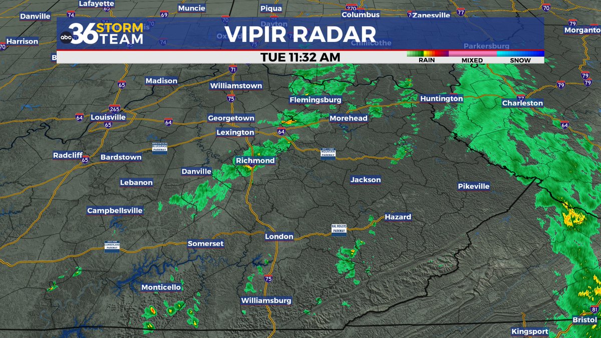

Tuesday outlook. Mostly cloudy. A stray shower or thunderstorm is possible. High 76°F. Winds NW at 5 to 10 mph. #Kywx #Lexingtonky #Kentucky


Rainfall totals were ABOVE normal for April. Most areas picked up between 4 and 6” of rain for the month. The Evansville Regional Airport finished with 6.27”. This was 1.38” above normal. #tristatewx #inwx #kywx


At @PlanoPanthers (Plano Elementary) in S Warren County talking @kymesonet with the kids. Lots of youngsters very interested in weather here! #outreach #kywx

On this day in 2005, eastern Kentucky was experiencing flash flooding as well as river flooding issues across a wide portion of the area to round out the month of April. #kywx


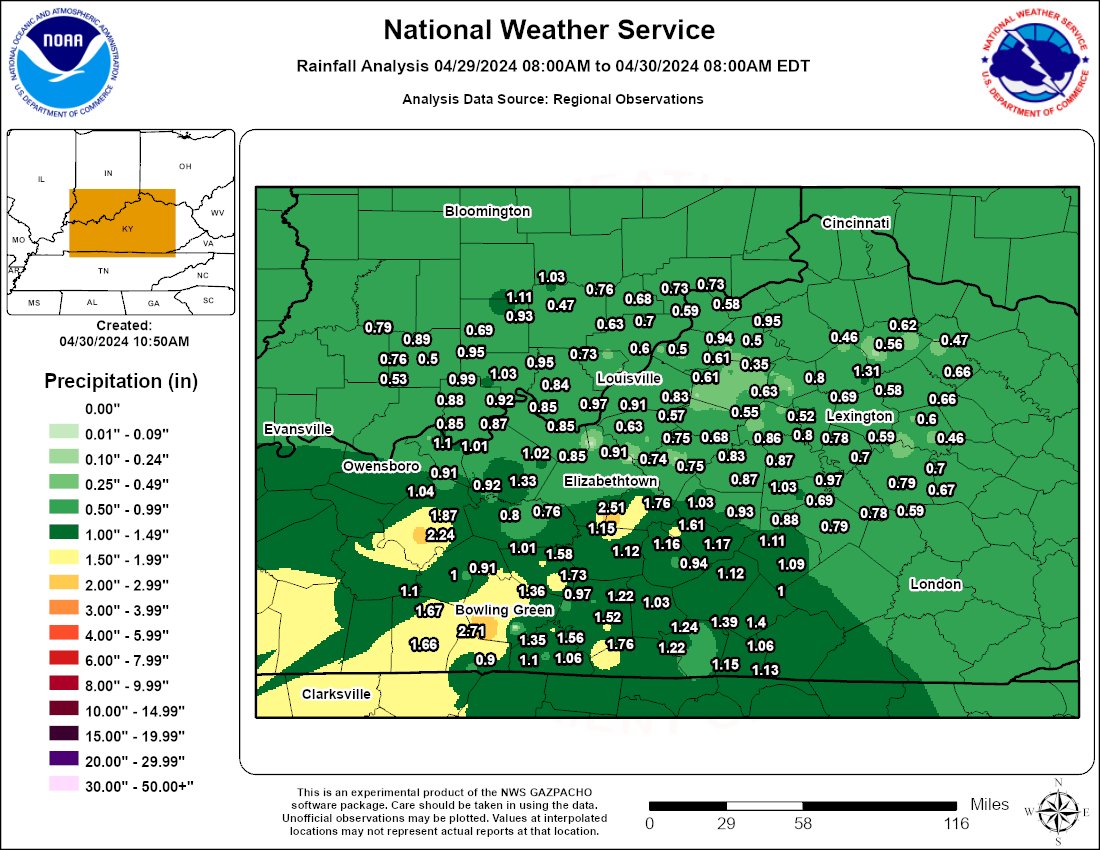
24 hour rainfall totals via the KY Mesonet. This has been a good, widespread, soaking rain. #18StormTracker #kywx

Some much needed rainfall across the tri-state over the last 24-hours. Rainfall amounts ranged from .40 to almost 1”. The heaviest rainfall was to the South and East of Evansville. #tristatewx #inwx #kywx @TMesonet

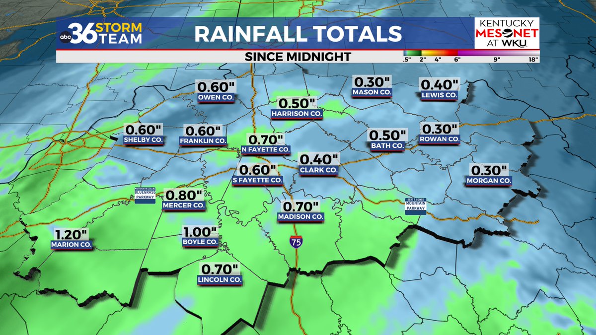
A healthy amount of rainfall has fallen since midnight across the region, with some Kentucky Mesonet sites in central Kentucky over 1" worth. #kywx


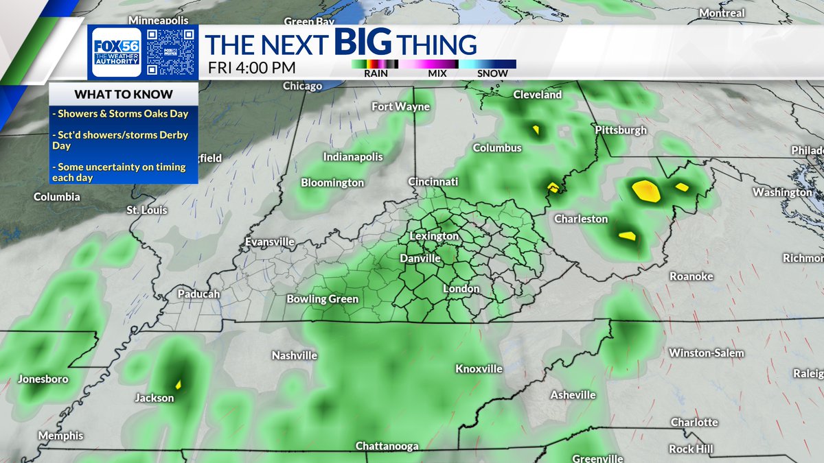
1st look at your #KYOaks & #KYDerby forecast, Friday looks the most active of the two. Showers & storms likely. Saturday looks a little better but occasional showers may linger. #18StormTracker #kywx

The widespread rain moves out this morning, but a few showers linger into the afternoon across eastern and southern KY. Highs in the low to mid 70s. #kywx


kywx @kywx
58 Followers 2 Following
#kywx Social @kywxSocial
158 Followers 50 Following User reported, user contributed. Send Kentucky Weather reports using #kywx! Follow @kywxSocial to keep up with current KY weather! Part of @SocialWeatherUS.
Kentucky Weather @CentralKYwx_
77 Followers 8 Following Breaking Weather Information for Centeral Kentucky!
Ky @Kywx13
30 Followers 24 Following

Marc Weinberg @MarcWeinbergWX
36K Followers 223 Following I am the Chief Meteorologist at WDRB in Louisville, KY. I love weather and I am blessed to share my passion on TV. My tweets are my own opinions. #kywx #inwx
WBKO First Alert Weat.. @WBKOWeather
28K Followers 150 Following Local. First. Now. The First Alert Weather team from @WBKOtv tweets the latest alerts, conditions & forecasts for #SCKY! #wbkowx #kywx #bgky
Clint Smalley @ClintKYwx
187 Followers 415 Following Kentucky Born and Raised. Ohio University Meteorology Grad.


kywx @BernardoErcoli
394 Followers 2K Following I was born, I ate, I grow up, etc (End of Thinking Capacity).
Kuidaore太郎 @sDX27by8qv3KYWx
344 Followers 920 Following 元プリンスホテル料理長。 新宿飲食店経営 飲食好き過ぎて収入の1/3は食費 全国にある美味しいグルメ、食事、ランチ、ディナー🍽をお届けします❗️ 全国の美味しいグルメをあなたに😋


mdzxe @KYwx4dx5d
8 Followers 6 Following
Brandon Spinner WCPO @wxSpinner89
9K Followers 2K Following 4x Emmy Nominated, Award Winning Meteorologist in Cincinnati, OH #OHwx #KYwx @ValpoU Grad. Fan of Jeff Gordon #Team24, #Cubs, #Blackhawks, #Dolphins, & #Bears
もんぶらん @bsxonPsy4KYwxSl
24 Followers 37 Following
لـ روح أبـي�.. @MZEauLw3KywxXzB
39 Followers 115 Following

Nathaniel The new Wea.. @NathanielKYWX
36 Followers 103 Following

Register 4 @wwo_kywxS
7 Followers 1 Following
al @WzqPHUvjKywx9bf
0 Followers 0 Following
るな🦕ネイル�.. @kywx_n
88 Followers 127 Following 渋谷駅8分🌿ネイルモデル様募集中🫧研修生の為通常価格より半額以下でご案内致します🫶デザイン2,000円、シンプル1,000円、フットは+500円🌷興味のある方はDM下さい。お直し、返金はできません。研修生のため仕上がりご了承ください💦遅刻、キャンセルはご遠慮ください。※女性専用サロンです💅🏻

আকাশ @UMZJOwKYWx4gTfx
16 Followers 0 Following
فؤادي بن عب�.. @zN3f2QWVfaKywx8
27 Followers 81 Following
Simonin killian @kywx2z__r
2 Followers 13 Following
Rin @e_kywx
65 Followers 213 Following 成人済//地方住み//新参審神者*刀ミュ中心🤍立花裕大🤍笹森裕貴❀江❀🌊 基本壁打ち*FC⇒刀ミュ、立花裕大、笹森裕貴 🗝▶︎ @z9v_71

محمد امين ح�.. @bMeuU7zFSkbKywx
6 Followers 3 Following
KY Weather Opinion �.. @KYWxOpinion
2 Followers 7 Following We provide weather coverage and opinions for the Bluegrass State.

⭐ @Ewsw4vj9UamKYWX
7 Followers 11 Following

KYWx @ruffnec72701140
7 Followers 18 Following

J.R. Lewis Hodge @KYWxMn9901
20 Followers 0 Following If you believe in something go after it with all you've got if you fail get up dust yourself off and try again, never give up even until your last breath!!!!
soar @kywx2000
32 Followers 1K Following
مطارق العبد.. @nT46RHRdKYwx1EQ
1 Followers 5 Following

Maiai @lwLvzzqJmKYWxIJ
26 Followers 0 Following
ひなひな @KVxGRE4mKywx20D
6 Followers 16 Following
工藤照美 @W5mOU97bMQsKYWX
0 Followers 9 Following
北見一孝 @tF4IqHPJHjnKYwx
6 Followers 7 Following
ملك @WGo68KYWx8CXsOC
1 Followers 1 Following
Mel @MugsyMel
601 Followers 610 Following Appreciation 4 weatherpeople & nature photos. #TWDfamily. Ex-Singer. Cloud & WKYT wx watcher. #KyWx Mom x2. Crazy cat lady. PokemonGo daily player. I ❤️Jesus.
Екатерина @qFWgn8KYWX1plsK
1 Followers 11 Following
アカウント変え.. @kywx15
83 Followers 152 Following

محمد طلعت م�.. @BIpSUy7KywxDom3
7 Followers 25 Following


Heronsbill's cat @nSsc9KYWx3PT74y
3 Followers 16 Following
อทิตยา �.. @8wv82KywxSx94dM
2 Followers 13 Following


Kywx _ @Kywx10
1 Followers 1 Following
دانيال الكن.. @XyufLryKYWxGdP9
0 Followers 1 Following

HASSAN YASSER @KYwxTJgdvJy7df0
0 Followers 24 Following


せいかくオバフ.. @nTG13KYWxZ74207
1 Followers 38 Following
ElvaJudd @VWSbXi0KYwx2Dpm
0 Followers 0 Following

محمد سليمان @KYWx9oNbwLk6vfZ
5 Followers 260 Following أبويوسف أخصائي علاج بالحجامة وعلاج بسم النحل والاعشاب
وافي السلمي @lPckfw73PvbKywx
0 Followers 24 Following


カール @bO6ulALOyvKYWX4
0 Followers 0 Following
吴宪 @kywx88888
0 Followers 0 Following

大山歩之渡 @hElqxKYWx119850
0 Followers 13 Following
TinaHolmes @p4642kywxVX0Q
0 Followers 0 Following

跑调的音乐人 @1xAq8yW5y5KYwxK
0 Followers 0 Following
大谷奈穂子 @kywx4AswnmkAmMg
0 Followers 0 Following
СанькаЙота @kywxXsLrTf5en2F
0 Followers 0 Following
DoloresHaydn @au0KywxZfyb1b6
0 Followers 0 Following
لاشي @KywxHNWjjOziika
1 Followers 40 Following لا أنتمي لثقافة المهمشة أحب التصاميم لهندستي العالميه
ต้น @ri9LypiKYWxT89j
1 Followers 6 Following

Kywx @eeduardomoriano
0 Followers 1 Following
吴宪 @kywx888888
0 Followers 1 Following
はらはら @8fKywxPZZeJjDLy
0 Followers 4 Following
ゆうき @cbktRhKywxP4T3G
0 Followers 4 Following
知優 坂下 @cr3AiaZdvKYwxEB
0 Followers 0 Following
Clayton Bylsma @Clayton0kywx
1 Followers 0 Following
พระจันท.. @jl0KYWX9RbfSAYv
0 Followers 0 Following
عصمت الله ا�.. @ldzKYwxOsaFW4Hs
0 Followers 17 Following
Wajid afridi @KywxT
3 Followers 38 Following
恩田佳代子 @KYwx02N8wv67534
0 Followers 5 Following
吴宪 @kywx8888
0 Followers 3 Following