Search results for #tnwx

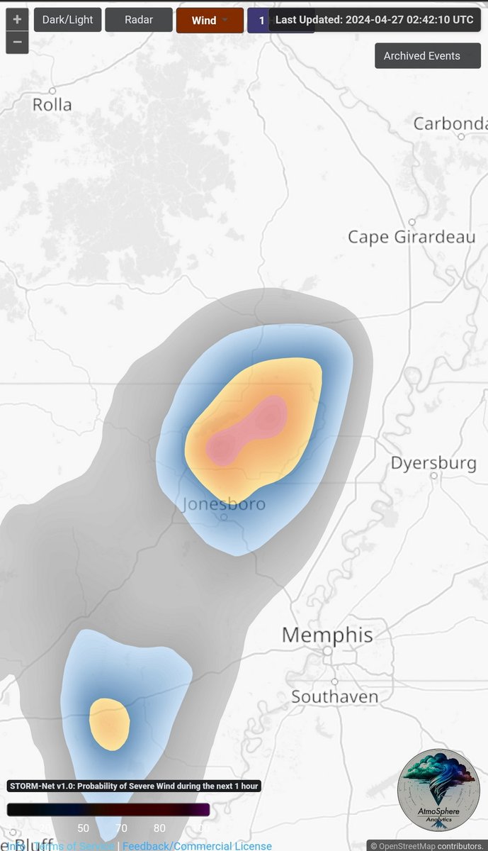
Damaging wind threat NE Arkansas into bootheel of Missouri. Low end tornado threat.#arwx #mowx #tnwx KNQA - Super-Res Reflectivity 1, 9:51 PM

We are watching some storms tonight in eastern Arkansas that are marching quickly towards the Mississippi River. The storms will cross into #WestTennessee during the 10pm hour but will weaken and run out of gas over the next couple of hours. #TNwx


April 26, 2024 - Fred Gossage is in the Tennessee Valley Weather Center on this Friday night with a final check of your local weather. #tnwx #alwx #mswx #weather #tnvalleyweather
April 26, 2024 - Fred Gossage is in the Tennessee Valley Weather Center on this Friday evening with your latest local forecast. #tnwx #alwx #mswx #weather #tnvalleyweather

Warm and windy weekend, here's what to expect to make your plans.#Nashville #FirstAlert #Nashville #tnwx #middletnwx @WSMV @WSMVweather


Here's what's unusual about this weekend's wind... #FirstAlert @WSMV #tnwx #kywx
Here's a look at current temperatures across the Mid-South. #tnwx #mswx #arwx @WMCActionNews5


We will have above average temps for the next several days. Next week we will have scattered June like storms. How warm could it get? I explain in my new weather forecast. #Knoxville #CHAwx #TNwx #GAwx link facebook.com/SoutheastTNand…

The 80s are here to stay for at least the next 7 days or so. Shower and thunderstorm chances will return Monday evening and stick around through the work week as we head into a slightly unsettled weather pattern. #alwx #tnwx #mswx #tnvalleyweather


RADAR UPDATE (1:30pm) | Showers continue to move east & will be ending later this evening. The plateau has already noticed the rain tapering off or ending all together. Clouds will begin to break from west to east, allowing for peaks of sun before sundown. #10Weather #WBIR #TNwx


Stage around 22' this morning and falling. The long term trend is down, and seven feet could be reached. Sand bars and river dikes will popup again. Despite all the pro Hamas riots in the country, let's pray God's will be done. Praise✝️🛐😇 #midsouthwx #tnwx #arwx #mswx #mowx


Late posting this but I spent a portion of my Wednesday soaking up the sun at Toyota Field for @trashpandas Education Day Game! We had the best time soaking up the sun and watching our boys play the Smokies! Are you going to any of the games this weekend? #ALWX #TNWX #TrashPandas
You'll NEVER BELIEVE Chris's first guess....I was just as shocked as you all will be! #WeatherWordle #ALWX #TNWX
#tnwx Social @tnwxSocial
133 Followers 50 Following User reported, user contributed. Send Tennessee Weather reports using #tnwx! Follow @tnwxSocial to keep up with current TN weather! Part of @SocialWeatherUS.

EastTennesseeWeather @EastTNWX
825 Followers 344 Following We provide weather forecasts and severe weather alerts for all counties in East Tennessee.
East TN Weather Lab @EastTNWxLab
41 Followers 12 Following Severe Weather Coverage for East Tennessee and Southeast Kentucky, keep up with the latest watches / warnings and severe weather analysis!
tnwx_sk @ThanawatSa45073
62 Followers 34 Following
かいと @KQyvgiTNWx86559
22 Followers 18 Following
Southeast Tennessee W.. @seTNwx
239 Followers 163 Following Up to the minute severe weather reports - #seTNwx


TNWX TASK FORCE @TNWX_TaskForce
87 Followers 77 Following | Volunteers in correlation with the NWS in Nashville to help protect life and property in the middle Tennessee area! |NOAA WRN Weather Ambassador.
p @tnwx_
27 Followers 2 Following
SumnerTNWX @SumnerTNWX
16 Followers 19 Following Your one stop for weather forecasts, conditions, and warnings for Sumner County Tennessee. Please share SumnerTNWX with your friends and family.
Lexington Weather @LexingtonTNWX
57 Followers 48 Following We provide weather updates for the Lexington, Tennessee area.
Patrick Ellis @PatrickEllisWx
9K Followers 3K Following Meteorologist @WMCActionNews5 〽️| Formerly: WABG, WNCT, WECT, WLBT |🏳️🌈. Opinions, views = mine. RT ≠ Endorsement. #mswx #tnwx #arwx #hailstate #geauxsaints
もなか @26tnwx4S15Dz9Wq
10 Followers 17 Following

CheathamSevereWx @CheathmSevereWx
2K Followers 170 Following Nowcasting forecasts & severe wx updates. We are associated w/ Cheatham County Weather on Facebook. Tweet ur reports & pics here! #tnwx #chcwx #tSpotter
무마 @i9Z1BwCplb1TNWx
39 Followers 51 Following

Dylan Randall @TNWxNerd
5 Followers 40 Following
Tennessee Valley Weat.. @tnvalleyweather
2K Followers 431 Following Providing daily forecast updates & to-the-minute severe weather info for Southern Middle Tennessee, Northwest Alabama, and Northeast Mississippi. #alwx #tnwx
علي عبده ال�.. @ACjcCE6uTnwxAsS
22 Followers 57 Following

علي خالد مح�.. @8nTNWX2mwdW4OCO
8 Followers 304 Following
ログアウトしま.. @o0Ys5zQb93TnwxP
165 Followers 288 Following
รดา @TnwxEscbqzKf4BO
4 Followers 18 Following

ثائر السعدي @0F7AEIwTNWx5lDQ
11 Followers 0 Following
A @tnwx_7
6 Followers 0 Following
ريم @ozTNwxCzW512323
0 Followers 0 Following
揚野国志 @Dz4ZYMMQmK4Tnwx
5 Followers 39 Following

Cory Smith @wxcory
3K Followers 2K Following @ABC24Memphis Meteorologist -Certified Drone Pilot - Rays Fan - Meme Connoisseur - @unccharlotte alumnus #memwx #tnwx


アリス @2ZzTNWxFvWRjVcE
2 Followers 2 Following

な @As0TNWxStWht4hT
1 Followers 2 Following
Jake Dalton @jdaltonwx
2K Followers 621 Following Meteorologist at @3onyourside | #HailState Alum | Dog Dad | Louisiana Born & Raised | #TNwx #MSwx #ARwx
متحف المفرو.. @65Tnwx6De1RAzVP
2 Followers 0 Following


ً @Tnwx_9
2 Followers 0 Following

ماقدر علئ ب�.. @qXbGBdFXjb2TNwx
2 Followers 3 Following


美尻セルカ🐷�.. @27uw2o885tnwx
2 Followers 4 Following

しゅん @YpH8jS2vTnwxN2b
1 Followers 2 Following

韩毅 @6spptTNWxKZySjr
3 Followers 58 Following
曾许清风 @fCPZ0vDxTNwxFXZ
2 Followers 10 Following
アカウント消去.. @Pq8Aoft9nF0TNwx
10 Followers 16 Following
vjyj33quua07rt @bo1tnwx3x
0 Followers 0 Following


. @sqnClTnwxZbQVvK
1 Followers 34 Following


🍎🍑🍒 @I45oZEpiTNwx9GW
0 Followers 7 Following

Amber Cavazos @c8tnwx78fw
0 Followers 2 Following
924933410 @TNWxXmIsDoBv6or
2 Followers 0 Following

柏 @TnwxVv
0 Followers 0 Following
中島千秋 @h7hKMbTNWxTAEj8
0 Followers 17 Following
tnwy_xa1 @tnwx_yt1
0 Followers 1 Following

안재령 @0NeTsJRI7tnwxHd
0 Followers 2 Following

서호승 @etmfN7JwgU9TNWx
0 Followers 2 Following

이선옥 @GMb73tnwxHJyjwd
0 Followers 3 Following
Tatyana Nicole @TNWx3
1 Followers 0 Following
ابو محمد @Z3TnwxK1RrhaLcJ
0 Followers 11 Following
だいしん @tnwx243tkq
0 Followers 11 Following 朝日新聞金沢総局です。キャラクターの名前は「マダム・ぞいね」。美人でしょ? コンセプトは石川県の地形を模した親指よ!能登の風、加賀の空気に触れながら…
あき @TNWxV50duGTSDlA
0 Followers 5 Following

篠崎勇 @uzo0TnwxT36zGdV
0 Followers 1 Following

8826207643 @9tnwxIdyC9IQ5PW
2 Followers 0 Following
عمرو دياب @vhTNwxOXzTwIbTS
4 Followers 291 Following
ジロー&プー @8aPG0TnwxLkLvpk
0 Followers 0 Following
زيزو بس @nhsiibBqBghTNwx
2 Followers 0 Following
森田均 @FCI9TNwx0f80705
0 Followers 0 Following
namabaiyyqiqquwvdbx @s279tnwx9r1
8 Followers 3 Following
T W Thanawat @TNWxCH
2 Followers 69 Following
望月正己 @9J5gx39IRayTNWx
1 Followers 12 Following
一雄 @TnwxVEUmevd2ZWP
0 Followers 1 Following
Шелест @LUMnLwLO782TNwx
0 Followers 18 Following
السفير ابور.. @TNWx2ILp5j6catm
1 Followers 9 Following
田部井 @Y6pMl4qzPd2tnwx
1 Followers 11 Following