Search results for #ctxwx

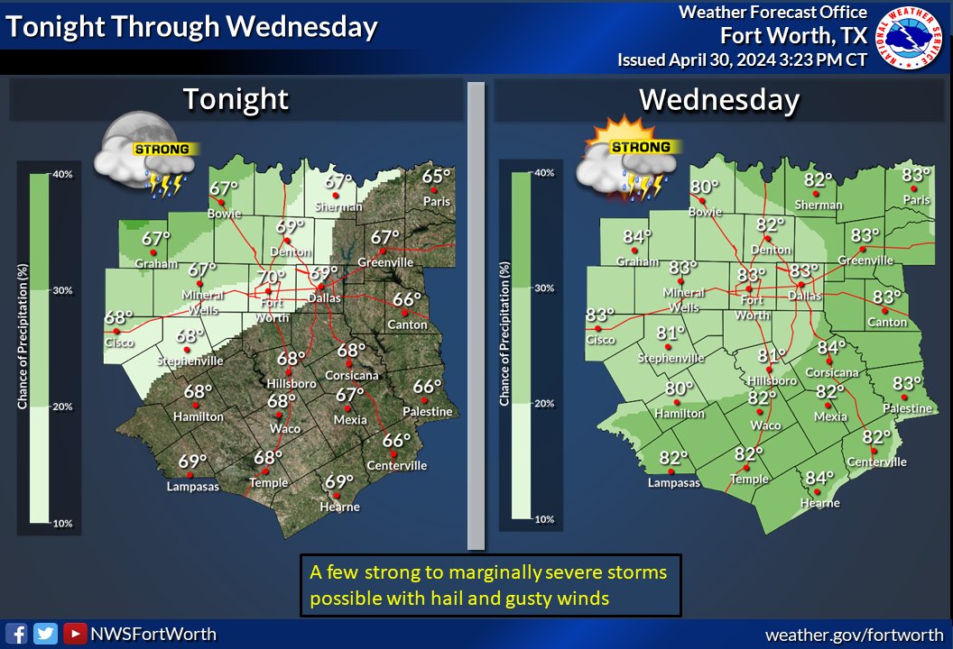
Storm chances return later today into tonight. The threat for severe weather and flooding has increased, especially tonight. Here's the latest timing of the storms. ⚠️Make sure to have multiple ways to receive alerts before you go to bed tonight. #dfwwx #ctxwx


D3 MRGL risk in C,S,NW US esp #Nashville,#Memphis,#BatonRouge,#Dallas,#FortWorth,#Austin,#SanAntonio,#TheWoodlands,#Wichita,#Topeka #Wxtwitter #SevereWX #FlashFlood #TXwx #DFW #DFWwx #HOUwx #CTXwx #OKwx #LAwx #MSwx #ALwx #ARwx #TNwx #KYwx #ILwx #KSwx #COwx #NEwx #ORwx #CAwx #WAwx

D3 MRGL risk in C,S,NW US esp #Nashville,#Memphis,#BatonRouge,#Dallas,#FortWorth,#Austin,#SanAntonio,#TheWoodlands,#Wichita,#Topeka #Wxtwitter #SevereWX #FlashFlood #TXwx #DFW #DFWwx #HOUwx #CTXwx #OKwx #LAwx #MSwx #ALwx #ARwx #TNwx #KYwx #ILwx #KSwx #COwx #NEwx #ORwx #CAwx #WAwx https://t.co/S8JnRGAZ1f


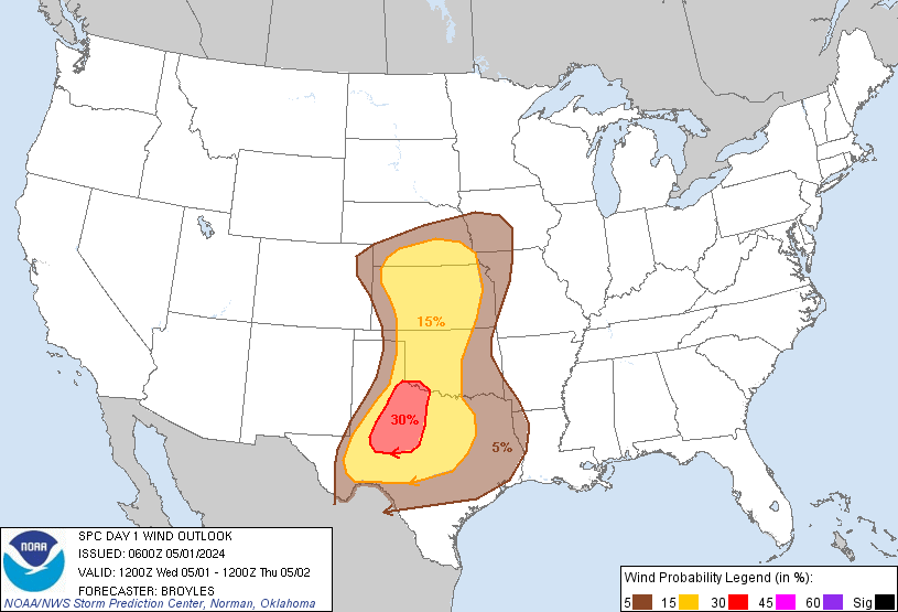
D1 MDT risk in E, C #Texas esp #Austin,#collegestation,#bryantx,#ROundrock,#SanMarcos,#CedarPark,#Waco,#TempleTX,#Killeen,#Corsicana,#Waxahachie,#TheWoodlands,#HuntsvilleTX,#GeorgetownTX,#Lufkin,#Conroe #Wxtwitter #SevereWX #FlashFlood #TXwx #CTXwx #DFWwx #BCSwx #DFW #HOUwx

D1 MDT risk in E, C #Texas esp #Austin,#collegestation,#bryantx,#ROundrock,#SanMarcos,#CedarPark,#Waco,#TempleTX,#Killeen,#Corsicana,#Waxahachie,#TheWoodlands,#HuntsvilleTX,#GeorgetownTX,#Lufkin,#Conroe #Wxtwitter #SevereWX #FlashFlood #TXwx #CTXwx #DFWwx #BCSwx #DFW #HOUwx https://t.co/PzefI6oKMw


D4 MRGL risk in NW,S US esp #BatonRouge,#Shreveport,#Houston,#Dallas,#FortWorth,#Huntsville,#Birmingham,#Nashville,#Lexington,#Portland #Wxtwitter #FlashFlood #LAwx #MSwx #TXwx #ARwx #ALwx #HOUwx #DFW #DFWwx #CTXwx #CAwx #ORwx #WAwx #GAwx #NCwx #TNwx #KYwx #INwx #WVwx #OHwx

D4 MRGL risk in NW,S US esp #BatonRouge,#Shreveport,#Houston,#Dallas,#FortWorth,#Huntsville,#Birmingham,#Nashville,#Lexington,#Portland #Wxtwitter #FlashFlood #LAwx #MSwx #TXwx #ARwx #ALwx #HOUwx #DFW #DFWwx #CTXwx #CAwx #ORwx #WAwx #GAwx #NCwx #TNwx #KYwx #INwx #WVwx #OHwx https://t.co/xAUPcYXjG9


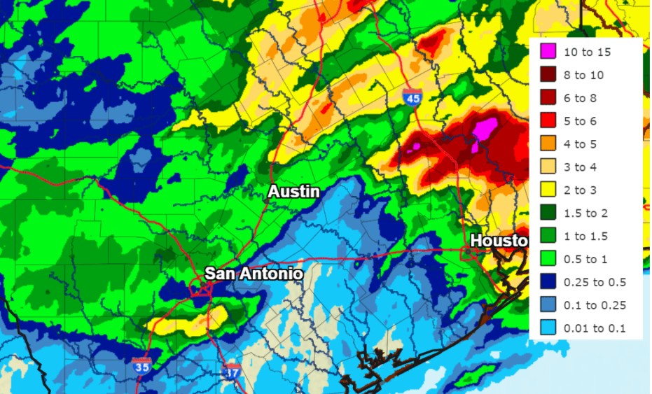
Another chance for rain and storms on Wednesday and continuing through the weekend. Read the full weather update from @BobRoseTX here: lcra.org/weather #TXWX #CTXWX #ATXWX
We noticed a discrepancy with wind speed on tornado #3 in the first graphic of the original post, so here is the corrected version. Tornado #3 on 4/26 should have a est. wind speed of 75 mph. #dfwwx #ctxwx #txwx


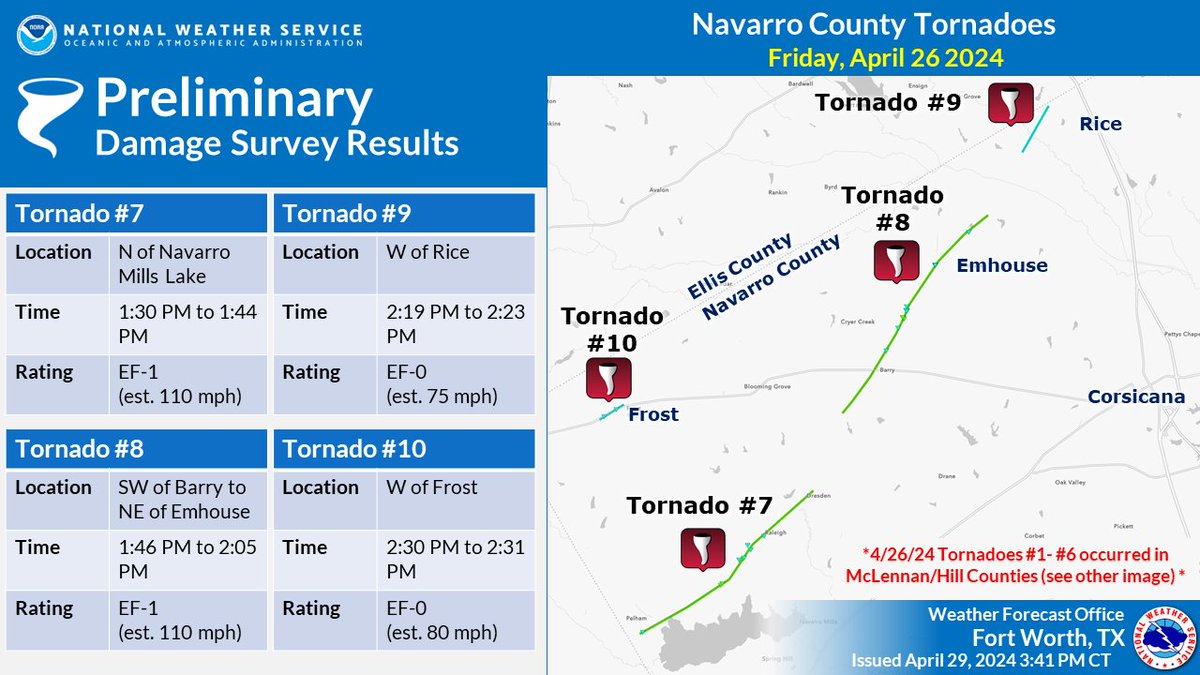
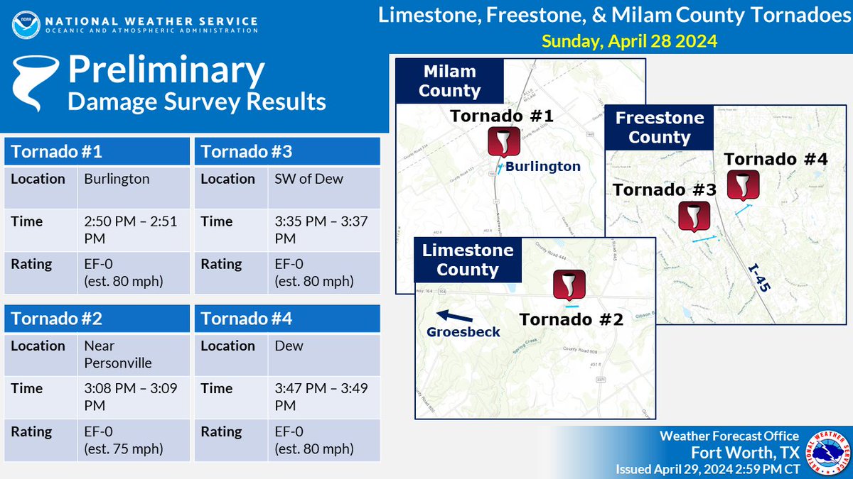
1:45 PM: The survey team has found the following: * 1 EF-0 SW of Dew (Freestone Co.) * 1 EF-0 in/near Dew (Freestone Co.) * 1 EF-0 near Personville/E of Groesbeck (Limestone Co.) We are still assessing damage near the Burlington area in Milam County. #ctxwx #txwx


。 @ctxwx
0 Followers 0 Following
SKYWARN Radio Desk @wx5fwd
4K Followers 57 Following The #SKYWARN® Storm Spotter Radio Desk Team for @NWSFortWorth. https://t.co/R5S1yIzAnR #FWDSpotter #TXWX #CTXWX #NTXWX #DFWWX
YNN Austin-area WX @ynntx_ctxwx
2 Followers 0 Following
伊藤美穂 @b7ctxwx1aVXAaLS
1 Followers 6 Following
김태경 @09mkCTXWxPBFJ90
0 Followers 1 Following